Künzell
| Künzell | ||
|---|---|---|
| ||
 Künzell | ||
Location of Künzell within Fulda district 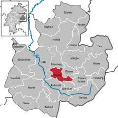
 | ||
| Coordinates: 50°33′N 9°43′E / 50.550°N 9.717°ECoordinates: 50°33′N 9°43′E / 50.550°N 9.717°E | ||
| Country | Germany | |
| State | Hesse | |
| Admin. region | Kassel | |
| District | Fulda | |
| Government | ||
| • Mayor | Timo Zentgraf (non party) | |
| Area | ||
| • Total | 30.29 km2 (11.70 sq mi) | |
| Population (2015-12-31)[1] | ||
| • Total | 16,322 | |
| • Density | 540/km2 (1,400/sq mi) | |
| Time zone | CET/CEST (UTC+1/+2) | |
| Postal codes | 36093 | |
| Dialling codes | 0661 | |
| Vehicle registration | FD | |
| Website | www.kuenzell.de | |

Künzell is a municipality in the district of Fulda, in Hesse, Germany. It is situated 3 km east of Fulda. It is twinned with the English village of Rustington.
The subdivisions are: Künzell/Bachrain, Pilgerzell, Engelhelms, Dirlos (with Loheland), Dietershausen, Keulos, Wissels and Dassen.
History
Early Middle Ages
In 743 a monk named Chindolf settled there in a cella. The place was named Chindecella or Kindecella.
Towns and municipalities in Fulda district | ||
|---|---|---|
References
- ↑ "Bevölkerung der hessischen Gemeinden". Hessisches Statistisches Landesamt (in German). August 2016.
This article is issued from Wikipedia - version of the 4/9/2016. The text is available under the Creative Commons Attribution/Share Alike but additional terms may apply for the media files.