K-171 (Kansas highway)
| ||||
|---|---|---|---|---|
| Route information | ||||
| Maintained by KDOT | ||||
| Length: | 4.890 mi[1] (7.870 km) | |||
| Existed: | 2003 – present | |||
| Major junctions | ||||
| West end: |
| |||
| East end: |
| |||
| Location | ||||
| Counties: | Cherokee, Crawford | |||
| Highway system | ||||
| ||||

K-171 is a state highway in the southeastern part of the U.S. state of Kansas. The 4.890-mile (7.870 km) highway mostly lies on the Crawford County/Cherokee County line except for the easternmost 0.4 miles (0.64 km) of the highway when it is entirely in Cherokee County. Its eastern terminus is at the Missouri state line near Opolis; its western terminus is at the intersection of U.S. Route 69/160 and U.S. Route 400 south of Pittsburg. K-171's current route was established in 2003, and the routing has not changed since.
Route description
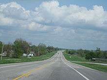
K-171 begins at a four-way stop south of Pittsburg.[2] The west arm of this intersection serves as US-400, the north arm carries US-69 and 160, the south arm is US-69, 160, and 400, and the east arm forms the beginning of K-171.[2] From this intersection, the highway heads due east to Opolis.[2] The highway begins to curve to the south just before crossing the state line and becoming Route 171 in Missouri.[2] The entire route travels through mostly rural fields.[2] The total length of the route is 4.890 miles (7.870 km). K-171 is not a part of the United States National Highway System.[3] The first 4.000 miles (6.437 km) of the route is paved with composite pavement and has annual average daily traffic values of 2600, while the remaining 0.890 miles (1.432 km) is paved with full design bituminous pavement and has annual average daily traffic values of 3271.[1]
History
The eastern K-171 was first designated in 2003.[4][5] Prior to K-171's formation, the road was a part of K-57.[4] The highway's route has stayed the same since it was commissioned.[2] For several years there was a western K-171 from the town of Bushton to K-4 highway.[4][5] This western K-171 was decommissioned in 2010.[6][7]
Junction list
| County | Location | mi[1] | km | Destinations | Notes |
|---|---|---|---|---|---|
| Cherokee–Crawford county line | | 0.000 | 0.000 | Western terminus; mainline continues west as US-400 | |
| Cherokee | Opolis | 4.890 | 7.870 | Eastern terminus; Missouri state line | |
| 1.000 mi = 1.609 km; 1.000 km = 0.621 mi | |||||
References
- 1 2 3 Kansas Department of Transportation. "2013 Condition Survey Report". Retrieved 2014-02-25.
- 1 2 3 4 5 6 Google (2014-02-25). "Google Map with K-171 highlighted" (Map). Google Maps. Google. Retrieved 2014-02-25.
- ↑ National Highway System (PDF) (Map). Kansas Department of Transportation. 2013. Retrieved 2014-02-25.
- 1 2 3 Official State Transportation Map (PDF) (PDF) (2003-2004 ed.). Kansas Department of Transportation.
- 1 2 Official State Transportation Map (PDF) (PDF) (2005-2006 ed.). Kansas Department of Transportation.
- ↑ Official State Transportation Map (PDF) (PDF) (2009-2010 ed.). Kansas Department of Transportation.
- ↑ Official State Transportation Map (PDF) (PDF) (2011-2012 ed.). Kansas Department of Transportation.