Cherokee, Kansas
| Cherokee, Kansas | |
|---|---|
| City | |
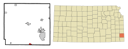 Location within Crawford County and Kansas | |
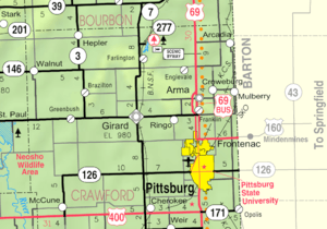 KDOT map of Crawford County (legend) | |
| Coordinates: 37°20′38″N 94°49′22″W / 37.34389°N 94.82278°WCoordinates: 37°20′38″N 94°49′22″W / 37.34389°N 94.82278°W | |
| Country | United States |
| State | Kansas |
| County | Crawford |
| Government | |
| • Type | Mayor–Council |
| Area[1] | |
| • Total | 0.71 sq mi (1.84 km2) |
| • Land | 0.71 sq mi (1.84 km2) |
| • Water | 0 sq mi (0 km2) |
| Elevation | 945 ft (288 m) |
| Population (2010)[2] | |
| • Total | 714 |
| • Estimate (2012[3]) | 718 |
| • Density | 1,000/sq mi (390/km2) |
| Time zone | Central (CST) (UTC-6) |
| • Summer (DST) | CDT (UTC-5) |
| ZIP code | 66724 |
| Area code(s) | 620 |
| FIPS code | 20-12825 [4] |
| GNIS feature ID | 0469610 [5] |
Cherokee is a city in Crawford County, Kansas, United States. As of the 2010 census, the city population was 714.[6]
History
Cherokee had its start in the year 1870 by the building of the railroad through that territory.[7] It was named from Cherokee County, where it was erroneously thought to be located.[8][9]
The first post office in Cherokee was established in August, 1870.[10]
Geography
According to the United States Census Bureau, the city has a total area of 0.71 square miles (1.84 km2), all of it land.[1]
Demographics
| Historical population | |||
|---|---|---|---|
| Census | Pop. | %± | |
| 1880 | 556 | — | |
| 1890 | 1,087 | 95.5% | |
| 1900 | 1,326 | 22.0% | |
| 1910 | 1,452 | 9.5% | |
| 1920 | 1,091 | −24.9% | |
| 1930 | 1,158 | 6.1% | |
| 1940 | 1,101 | −4.9% | |
| 1950 | 849 | −22.9% | |
| 1960 | 797 | −6.1% | |
| 1970 | 790 | −0.9% | |
| 1980 | 775 | −1.9% | |
| 1990 | 651 | −16.0% | |
| 2000 | 722 | 10.9% | |
| 2010 | 714 | −1.1% | |
| Est. 2015 | 713 | [11] | −0.1% |
| U.S. Decennial Census | |||
2010 census
As of the census[2] of 2010, there were 714 people, 289 households, and 187 families residing in the city. The population density was 1,005.6 inhabitants per square mile (388.3/km2). There were 324 housing units at an average density of 456.3 per square mile (176.2/km2). The racial makeup of the city was 95.9% White, 0.1% African American, 0.8% Native American, 0.3% from other races, and 2.8% from two or more races. Hispanic or Latino of any race were 1.5% of the population.
There were 289 households of which 33.2% had children under the age of 18 living with them, 46.7% were married couples living together, 11.8% had a female householder with no husband present, 6.2% had a male householder with no wife present, and 35.3% were non-families. 27.3% of all households were made up of individuals and 10.8% had someone living alone who was 65 years of age or older. The average household size was 2.47 and the average family size was 2.97.
The median age in the city was 39.7 years. 27% of residents were under the age of 18; 8.3% were between the ages of 18 and 24; 24.2% were from 25 to 44; 26.8% were from 45 to 64; and 13.9% were 65 years of age or older. The gender makeup of the city was 51.5% male and 48.5% female.
2000 census
As of the census[4] of 2000, there were 722 people, 301 households, and 192 families residing in the city. The population density was 1,052.2 people per square mile (404.0/km²). There were 336 housing units at an average density of 489.7 per square mile (188.0/km²). The racial makeup of the city was 95.43% White, 0.28% African American, 0.97% Native American, 0.14% Asian, and 3.19% from two or more races. Hispanic or Latino of any race were 0.42% of the population.
There were 301 households out of which 29.6% had children under the age of 18 living with them, 50.5% were married couples living together, 8.0% had a female householder with no husband present, and 36.2% were non-families. 32.2% of all households were made up of individuals and 16.6% had someone living alone who was 65 years of age or older. The average household size was 2.40 and the average family size was 3.03.
In the city the population was spread out with 26.7% under the age of 18, 6.8% from 18 to 24, 24.9% from 25 to 44, 25.1% from 45 to 64, and 16.5% who were 65 years of age or older. The median age was 38 years. For every 100 females there were 96.7 males. For every 100 females age 18 and over, there were 94.5 males.
The median income for a household in the city was $29,083, and the median income for a family was $36,389. Males had a median income of $26,739 versus $18,810 for females. The per capita income for the city was $14,693. About 7.8% of families and 14.5% of the population were below the poverty line, including 24.4% of those under age 18 and 14.4% of those age 65 or over.
Government
The Cherokee government consists of a mayor and five council members. The council meets the 2nd Thursday of each month at 6:30PM.[12]
Notable people
- Page Cavanaugh, jazz and pop musician, was born in Cherokee.
- W. Darrell Overdyke, American historian, was born in Cherokee and was a long-time professor at Centenary College of Louisiana.
- Samuel S. Triplett, Spanish–American War Medal of Honor recipient.[13]
References
- 1 2 "US Gazetteer files 2010". United States Census Bureau. Archived from the original on 2012-01-24. Retrieved 2012-07-06.
- 1 2 "American FactFinder". United States Census Bureau. Retrieved 2012-07-06.
- ↑ "Population Estimates". United States Census Bureau. Archived from the original on 2013-06-17. Retrieved 2013-05-29.
- 1 2 "American FactFinder". United States Census Bureau. Archived from the original on 2013-09-11. Retrieved 2008-01-31.
- ↑ "US Board on Geographic Names". United States Geological Survey. 2007-10-25. Retrieved 2008-01-31.
- ↑ "2010 City Population and Housing Occupancy Status". U.S. Census Bureau. Archived from the original on July 21, 2011. Retrieved May 10, 2011.
- ↑ Blackmar, Frank Wilson (1912). Kansas: A Cyclopedia of State History, Embracing Events, Institutions, Industries, Counties, Cities, Towns, Prominent Persons, Etc. Standard Publishing Company. pp. 317–318.
- ↑ Kansas State Historical Society (1916). Biennial Report of the Board of Directors of the Kansas State Historical Society. Kansas State Printing Plant. p. 171.
- ↑ "Profile for Cherokee, Kansas". ePodunk. Retrieved 8 June 2014.
- ↑ "Kansas Post Offices, 1828-1961 (archived)". Kansas Historical Society. Archived from the original on October 9, 2013. Retrieved 6 June 2014.
- ↑ "Annual Estimates of the Resident Population for Incorporated Places: April 1, 2010 to July 1, 2015". Retrieved July 2, 2016.
- ↑ Cherokee - Directory of Public Officials Archived May 5, 2011, at the Wayback Machine.
- ↑ "War with Spain Medal of Honor recipients". Medal of Honor citations. United States Army Center of Military History. September 1, 2004. Retrieved June 5, 2014.
External links
| Wikimedia Commons has media related to Cherokee, Kansas. |
- City
- Schools
- USD 247, local school district
- Maps
- Cherokee City Map, KDOT
Municipalities and communities of Crawford County, Kansas, United States | ||
|---|---|---|
| Cities | 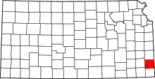 | |
| Townships | ||
| CDPs | ||
| Unincorporated communities | ||
| Footnotes | ‡This populated place also has portions in an adjacent county or counties | |