K-42 (Kansas highway)
| ||||
|---|---|---|---|---|
 | ||||
| Route information | ||||
| Maintained by KDOT | ||||
| Length: | 75 mi (121 km) | |||
| Major junctions | ||||
| West end: |
| |||
| East end: |
| |||
| Location | ||||
| Counties: | Pratt, Kingman, Sumner, Sedgwick | |||
| Highway system | ||||
| ||||

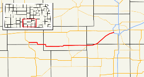
K-42 is a 75-mile (120.799 km) state highway in the U.S. state of Kansas. The highway serves as a connection to Wichita for communities between the US-160 and US-54 corridors.
Route description
It begins at US-281 in Sawyer and travels southeast to Isabel where it rides the Barber/Pratt county line until it enters Kingman County, where it passes through Nashville, Zenda, and Spivey. North of Rago it intersects K-14 then continues on to pass through Norwich.
After entering Sedgwick County, it passes through Viola where K-49's northern terminus is. It continues northeast into south Wichita and terminates at Exit 5 on I-235.
History
K-42 once terminated at US-54 and US-400. The route was truncated to I-235 around 2003, when it was removed from the official Kansas map.
Major intersections
| County | Location | mi | km | Destinations | Notes |
|---|---|---|---|---|---|
| Pratt | Sawyer | 0.0 | 0.0 | Western terminus; road continues as Broadway Street | |
| Kingman | Rago | 32.759 | 52.721 | ||
| Sumner | | 48.911 | 78.715 | Eastern terminus of K-2 | |
| Sedgwick | Viola | 57.494 | 92.528 | Northern terminus of K-49 | |
| Wichita | 75.061 | 120.799 | Eastern terminus; I-235 exit 5; road continues NE as Southwest Boulevard | ||
| 1.000 mi = 1.609 km; 1.000 km = 0.621 mi | |||||