K-49 (Kansas highway)
| ||||
|---|---|---|---|---|
 | ||||
| Route information | ||||
| Maintained by KDOT | ||||
| Length: | 29.9 mi (48.1 km) | |||
| Major junctions | ||||
| South end: |
| |||
| North end: |
| |||
| Location | ||||
| Counties: | Sedgwick, Sumner | |||
| Highway system | ||||
| ||||

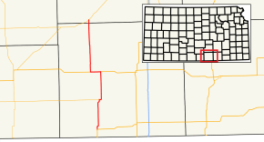
K-49 is a 29.9-mile-long (48.1 km) state highway in the U.S. state of Kansas. It is a north–south highway that connects communities southwest of Wichita to U.S. Highway 81 (US-81). The majority of the route exists in Sumner County, with only a mile existing in Sedgwick County.
Route description
K-49 begins in downtown Caldwell at an intersection with US-81 and West Central Avenue, traveling north as Main Street. Leaving the city, the highway shifts east slightly with an S-shaped curve, and passes through flat farmland. It crosses the Chikaskia River west of Corbin, and shifts northeast to avoid a second crossing with the river before intersecting the eastern terminus of K-44 in a slightly wooded area, where it shifts east once again with a gentle S-shaped curve. K-49 then continues north through flat fields, where it intersects the Chisholm Trail. It continues north and has a grade crossing with a BNSF Railway line a mile south of US-160, where it shares a three-mile (4.8 km) concurrency with the U.S. Highway. After traveling west with US-160, the highway resumes its northerly course toward Conway Springs through more flat fields, and passing through the town. K-49 meets the Kansas and Oklahoma Railroad with an at-grade crossing on the northern city limit. The highway continues north, crossing Slate Creek, before arriving at the northern Sumner county border. Upon crossing into Sedgwick County, it immediately arrives at Viola, where it meets its northern terminus at K-42.[1]
History
K-49 has followed the same route since its creation around 1932.[2]
Major junctions
| County | Location | mi[3] | km | Destinations | Notes |
|---|---|---|---|---|---|
| Sumner | Caldwell | 0.0 | 0.0 | Southern terminus | |
| | 8.9 | 14.3 | |||
| | 17.3 | 27.8 | Southern end of US-160 concurrency | ||
| | 20.3 | 32.7 | Northern end of US-160 concurrency | ||
| Sedgwick | Viola | 29.88 | 48.09 | Northern Terminus | |
1.000 mi = 1.609 km; 1.000 km = 0.621 mi
| |||||
See also
 Kansas portal
 U.S. Roads portal
References
- ↑ Kansas Department of Transportation (2015). There's No Place Like Kansas: Official State Transportation Map (PDF) (Map). Scale not given. Topeka: Kansas Department of Transportation. Retrieved August 3, 2015.
- ↑ State Highway Commission of Kansas (1932). Kansas State Highway System: Showing Route Numbers and Construction Progress (PDF) (Map). Scale not given. Topeka: State Highway Commission of Kansas. Retrieved August 3, 2015.
- ↑ Kansas Department of Transportation (2014). "2014 Condition Survey Report". Topeka: Kansas Department of Transportation. Retrieved August 3, 2015.