K-51 (Kansas highway)
| ||||
|---|---|---|---|---|
 | ||||
| Route information | ||||
| Maintained by KDOT | ||||
| Major junctions | ||||
| West end: | County Road M at Colorado State Line between Baca County, CO and Morton County | |||
|
| ||||
| East end: |
| |||
| Location | ||||
| Counties: | Morton, Stevens, Seward | |||
| Highway system | ||||
| ||||
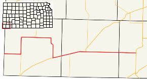
K-51 is a west-east state highway in the southwestern part of the U.S. state of Kansas. It travels through portions of Morton, Stevens, and Seward counties.
Route description
K-51 begins at the Colorado state line, acting as a continuation of County Road M. The highway travels due east through fields. K-51 then turns north onto K-27, forming a 10 mile (16 km) long concurrency. K-27 leaves at Richfield. K-51 runs eastward for a few miles before heading south towards Rolla. In Rolla, US-56 is met, and K-51 turns east onto US-56, crossing into Stevens County. Both routes then pick up northbound K-25, with all three routes heading into Hugoton. In the city itself, US-56 and K-25 turn north, leaving K-51 to head east on its own. The route goes eastward, entering Seward County. K-51 comes to an end north of Liberal at US-83.
History
Until 1983, the portion of K-51 between Hugoton and US-83 was shared with a previous alignment of US-270.[1]
Junction List
| County | Location | mi | km | Destinations | Notes |
|---|---|---|---|---|---|
| Morton | | 0.0 | 0.0 | County Road M west | Continuation beyond Colorado state line |
| | 7.8 | 12.6 | Western end of K-27 concurrency | ||
| Richfield | 22.3 | 35.9 | Eastern end of K-27 concurrency | ||
| Rolla | 39.7 | 63.9 | Western end of US-56 concurrency | ||
| Stevens | | 47.9 | 77.1 | Western end of K-25 concurrency | |
| Hugoton | 55.5 | 89.3 | Eastern end of US-56/K-25 concurrency | ||
| Seward | | 79.005 | 127.146 | ||
1.000 mi = 1.609 km; 1.000 km = 0.621 mi
| |||||
