U.S. Route 270
| |
|---|---|
 | |
| Route information | |
| Auxiliary route of US 70 | |
| Length: | 643 mi (1,035 km) |
| Existed: | 1930[1] – present |
| Major junctions | |
| West end: |
|
| East end: |
|
| Location | |
| States: | Kansas, Oklahoma, Arkansas |
| Highway system | |

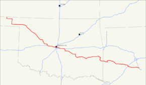
U.S. Route 270 (US 270) is a spur of U.S. Route 70. It runs for 643 miles (1,035 km) from Liberal, Kansas at U.S. Route 54 to White Hall, Arkansas at Interstate 530 and U.S. Route 65. It passes through the states of Arkansas, Oklahoma, and Kansas. It goes through the cities of Oklahoma City, Oklahoma, Hot Springs, Arkansas, and McAlester, Oklahoma.
Route description
Kansas
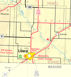
US 270 begins in the southeast part of Liberal, Kansas, at an intersection with US 83 (running north–south through the intersection) and US 54. US 270 follows the south leg of this intersection, following US 83 south. US 270 only spends 3 miles (4.8 km) in Kansas before crossing into Oklahoma. Seward County is the only county that US-270 serves.
Oklahoma
US 270 enters Oklahoma in Beaver County, the eastern third of the Oklahoma Panhandle. From here it continues east along US 64, then south towards Beaver, the county seat, along SH-23. South of Beaver, the road joins with US 412 (OK) and SH-3, the latter of which US 270 will overlap with through most of northwest Oklahoma. After leaving the Panhandle and picking up US 183 near Fort Supply, the highways turn southwest towards Woodward. US 412 splits away in Woodward. US 270, concurrent with US 183 and SH-3, proceed southeast toward Seiling. West of Seiling, US 183 splits off to the south, but in Seiling, it is replaced by US 281. The routes continue southwest to Watonga, where US 270/281 turn south along SH-8, while SH-3 continues due east to concur with SH-33. In Geary, US 270 splits off on an independent alignment, looping through Calumet before joining with Interstate 40.
US 270 remains concurrent with I-40 from Exit 115 through Exit 181, a distance of 66 miles (106 km). US 270, attached to I-40, runs through the core of the Oklahoma City Metro area, passing through the western suburbs of El Reno and Yukon into Oklahoma City proper. The partnership runs just south of Downtown and the Bricktown entertainment district on the Crosstown Expressway. Major interchanges with I-44 and I-35 (the latter involving a concurrency with the interstate and its accompanying US Highway, US 62) are found in the city. I-40/US 270 also serve two eastern suburbs of Oklahoma City, Del City and Midwest City and form the northern boundary between Midwest City's civilian areas and Tinker Air Force Base. US-270 finally exits from I-40 on the west side of Shawnee.
US 270 serves most of the towns anchoring the area east of Oklahoma City, including Shawnee, Tecumseh, Seminole, Wewoka, and Holdenville. It continues southeast to the city of McAlester, a major southeastern Oklahoma city. It also serves many of the small towns east of McAlester, such as Krebs, Alderson, Bache, Haileyville, and Hartshorne.
After passing through Hartshorne, the roads curves to the northeast before turning onto a due east course taking it through Wilburton, Red Oak, and Wister. In Wister, it turns south, running across Wister Lake's dam, and proceeding southeast to Heavener. There, it meets US 59, which it will follow for the rest of its time in Oklahoma. The town highways head south from Heavener, passing through the Wister Wildlife Management Area before entering the Ouachita National Forest. The route serves as the northern terminus of US 259 near Page. The road then squeezes into a valley between Black Fork Mountain and Rich Mountain. In this valley, it crosses the state line into Arkansas.
Arkansas

US 270 enters Arkansas with US 59, and runs east to Acorn, where it meets US 71. The route then travels 15 miles north on US 71 to Y City where it splits off and continues east. The route then meets AR 88 in Pencil Bluff and AR 27 in Mt. Ida before heading to Hot Springs. Entering the city, US 270 meets US 70 southwest of town and runs concurrent with it through downtown Hot Springs. After leaving Hot Springs, US 270 enters Malvern briefly with I-30 and runs downtown with US 67. US 270 meets AR 229 in Poyen and AR 190/AR 291 in Prattsville before crossing paths with US 167 in Sheridan. The route trails east towards Pine Bluff to AR 365S/US 65/I-530 near White Hall, where the route terminates.
History
In Arkansas, US-270 was formerly Highway 6.
Future
In Arkansas, it has been proposed that part of AR-51 will become part of US-270. On I-30's current concurrency with US-270, going east, drivers can take exit 99 and make a right on US-270 East. If drivers make a left when they take exit 99, they must make a left to get on I-30 West/US-270 West because there is currently no outlet past that. That road has been proposed to be extended to AR-51. This will form the future northern terminus of AR-51. This means that drivers can make a left to get on AR-51 South and will have to make a right to get on US-270 West. Then, US-270 will meet the current US-270. Drivers can make a left to get on the future US-270 Business East and must make a right to get on US-270 West, just like AR-51 did. From east to west, the future US-270 will go through the cities of Rockport, Butterfield, and Magnet Cove.
Major intersections
| State | County | Location | mi | km | Exit | Destinations | Notes | |
|---|---|---|---|---|---|---|---|---|
| Kansas | Seward | Liberal | west end of US-83 overlap | |||||
| Oklahoma | Beaver | | east end of US-83 overlap; west end of US-64 overlap | |||||
| | east end of US-64 overlap; west end of SH-23 overlap | |||||||
| Elmwood | east end of SH-23 overlap; west end of US-412 / SH-3 overlap | |||||||
| Harper | Log Cabin Corner | |||||||
| May | ||||||||
| Ellis |
No major junctions | |||||||
| Woodward | | west end of US-183 overlap | ||||||
| Woodward | ||||||||
| east end of US-412 overlap; west end of SH-34 overlap | ||||||||
| | east end of SH-34 overlap | |||||||
| | ||||||||
| Woodward–Major county line | | east end of US-183 overlap | ||||||
| Dewey | Seiling | west end of US-60 / US-281 overlap | ||||||
| east end of US-60 overlap; west end of SH-51 overlap | ||||||||
| | east end of SH-51 overlap | |||||||
| Blaine | | west end of SH-33 overlap | ||||||
| Watonga | east end of SH-3 / SH-33 overlap; west end of SH-8 overlap | |||||||
| Geary | east end of US-281 / SH-8 overlap | |||||||
| Canadian | | west end of I-40 overlap; US-270 west follows exit 115 | ||||||
| see I-40 | ||||||||
| Pottawatomie | Clarks Heights | east end of I-40 / SH-3 overlap; west end of US-177 / SH-3W overlap; US-270 east follows exit 181 | ||||||
| Shawnee | interchange | |||||||
| interchange | ||||||||
| Tecumseh | Tecumseh (Broadway) | interchange | ||||||
| interchange; east end of US-177 / SH-3W overlap; west end of SH-9 overlap | ||||||||
| | west end of SH-9A overlap | |||||||
| Earlsboro | east end of SH-9A overlap | |||||||
| Seminole | Seminole | east end of SH-9 overlap; west end of SH-3E overlap | ||||||
| east end of SH-3E overlap | ||||||||
| | ||||||||
| | interchange | |||||||
| Wewoka | ||||||||
| Hughes | Holdenville | |||||||
| | ||||||||
| Horntown | west end of US-75 overlap | |||||||
| | interchange; east end of US-75 overlap; west end of SH-1 overlap | |||||||
| | ||||||||
| Pittsburg | | Indian Nation Turnpike exit 70 | ||||||
| McAlester | west end of SH-31 overlap | |||||||
| interchange | ||||||||
| Krebs | interchange; east end of SH-31 overlap | |||||||
| Haileyville | west end of SH-63 overlap | |||||||
| | east end of SH-1 / SH-63 overlap | |||||||
| Latimer | Wilburton | west end of SH-2 overlap | ||||||
| east end of SH-2 overlap | ||||||||
| Red Oak | west end of SH-82 overlap | |||||||
| | east end of SH-82 overlap | |||||||
| Le Flore | Fanshawe | west end of US-271 overlap | ||||||
| Wister | east end of US-271 overlap | |||||||
| Heavener | west end of US-59 overlap | |||||||
| | ||||||||
| Arkansas | Polk | Rich Mountain | ||||||
| Acorn | east end of US 59 overlap; west end of US 71 overlap | |||||||
| Scott | "Y" City | east end of US 71 overlap | ||||||
| proposed | ||||||||
| Montgomery | Pencil Bluff | west end of AR 88 overlap | ||||||
| east end of AR 88 overlap | ||||||||
| | ||||||||
| | west end of AR 27 overlap | |||||||
| Mount Ida | east end of AR 27 overlap | |||||||
| | ||||||||
| | ||||||||
| Joplin | ||||||||
| Garland | | |||||||
| | ||||||||
| Piney | ||||||||
| Hot Springs | 1 | interchange; west end of freeway | ||||||
| 2 | west end of US 70 overlap | |||||||
| 3 | Mc Leod Street | |||||||
| 4 | ||||||||
| 5 | signed as exits 5A (south) and 5B (north) | |||||||
| 7 | ||||||||
| interchange; east end of freeway; east end of US 70 overlap; US 270 east follows exit 9 | ||||||||
| | ||||||||
| Hot Spring | Magnet Cove | |||||||
| Rockport | ||||||||
| Malvern | west end of I-30 overlap; US 270 west follows exit 98B | |||||||
| Rockport | east end of I-30 overlap; US 270 east follows exit 99 | |||||||
| | ||||||||
| Grant | Poyen | |||||||
| Prattsville | west end of AR 291 overlap | |||||||
| east end of AR 291 overlap | ||||||||
| Sheridan | ||||||||
| Jefferson | | |||||||
| White Hall | I-530 exit 34 | |||||||
| 1.000 mi = 1.609 km; 1.000 km = 0.621 mi | ||||||||
Bannered routes
Hot Springs business loop
| |
|---|---|
| Location: | Hot Springs, Ark. |
| Length: | 9.4 mi (15.1 km) |
U.S. Highway 270B is a 9.4-mile-long (15.1 km) business route in Garland County, Arkansas. It runs through downtown Hot Springs, Arkansas.
Other loops and spurs
- Seminole, Oklahoma; Short highway connecting U.S. 270 to OK-9. This highway is disputed as a state or U.S. highway, as both signs are posted.
- Magnet Cove, Arkansas (decommissioned)
- Malvern, Arkansas
References
- ↑ Droz, Robert V. U.S. Highways : From US 1 to (US 830). URL accessed 19 March 2006.
External links
| Browse numbered routes | ||||
|---|---|---|---|---|
| ← | KS | K-271 | ||
| ← | OK | SH-270 | ||
| ← | AR | US 271 | ||