Kaʻaʻawa, Hawaii
| Kaaawa, Hawaii | |
|---|---|
| Census-designated place | |
|
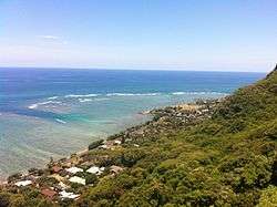
View from Crouching Lion near Kahana Valley | |
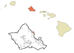
 Location in Honolulu County and the state of Hawaiʻi | |
| Coordinates: 21°33′25″N 157°51′19″W / 21.55694°N 157.85528°WCoordinates: 21°33′25″N 157°51′19″W / 21.55694°N 157.85528°W | |
| Country | United States |
| State | Hawaiʻi |
| Area | |
| • Total | 1.3 sq mi (3.4 km2) |
| • Land | 0.8 sq mi (2.1 km2) |
| • Water | 0.5 sq mi (1.4 km2) |
| Elevation | 6 ft (2 m) |
| Population (2010) | |
| • Total | 1,379 |
| • Density | 1,100/sq mi (410/km2) |
| Time zone | Hawaii-Aleutian (UTC-10) |
| ZIP code | 96730 |
| Area code(s) | 808 |
| FIPS code | 15-19550 |
| GNIS feature ID | 0359551 |

Kaʻaʻawa is a small community and census-designated place (CDP) located in the windward district of Koʻolauloa, City & County of Honolulu on the island of Oʻahu, Hawaiʻi, United States. As of the 2010 Census, the total population for Kaʻaʻawa was 1,379.[1] In Hawaiian, kaʻaʻawa means "the wrasse (fish)".[2] From the Hawaiian spelling Kaʻaʻawa it is seen that each a is pronounced separately and distinctly, set apart by the two ʻokinas: [ˈkɐʔəˈʔɐvə] or [ˈkɐʔəˈʔɐwə].
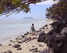
Kaʻaʻawa is north of Kāneʻohe Bay (north of Kaʻōʻio Point, also Kalaeokaʻōʻio), and the Pacific Ocean shore here is fronted by a broad fringing reef with a narrow, but quite inviting beach (Kanenelu Beach, Kalaeʻōʻio Beach Park, and Kaʻaʻawa Beach Park). The around-the-island-highway (Kamehameha Highway, State Rte. 83) and the houses and other buildings comprising the town, are confined to a relatively narrow belt along the coast. However, a long valley extends inland. Kaʻaʻawa Valley is part of Kualoa Ranch and used for various tourist activities as well as filming. Major films and TV series incorporating significant views of the valley include George of the Jungle, Jurassic Park and Lost.
The U.S. postal code for Kaʻaʻawa is 96730.
Geography
Kaʻaʻawa is located at 21°33′25″N 157°51′19″W / 21.55694°N 157.85528°W (21.557050, -157.855148).[3] Kaʻaʻawa is north of Kualoa and directly southeast of Kahana Bay. The next place beyond Kahana is Punaluʻu.
According to the United States Census Bureau, the CDP has a total area of 1.3 square miles (3.4 km2). 0.81 square miles (2.1 km2) of it is land, and 0.54 square miles (1.4 km2) of it is water. The total area is 39.72% water.[4]
Demographics
As of the 2000 Census, there were 1,324 people, 469 households, and 323 families residing in the Ka'a'awa census tract. The population density was 2,250.6 people per square mile (866.4/km²). There were 550 housing units at an average density of 934.9 per square mile (359.9/km²). The racial makeup of the CDP was 35.88% White, 0.45% Black or African American, 0.38% Native American, 8.76% Asian, 22.66% Pacific Islander, 1.13% from other races, and 30.74% from two or more races. 8.23% of the population were Hispanic or Latino of any race.
There were 469 households out of which 31.1% had children under the age of 18 living with them, 52.5% were married couples living together, 10.4% had a female householder with no husband present, and 31.1% were non-families. 24.3% of all households were made up of individuals and 6.2% had someone living alone who was 65 years of age or older. The average household size was 2.82 and the average family size is 3.36.
In the CDP the population was spread out with 26.4% under the age of 18, 7.6% from 18 to 24, 28.9% from 25 to 44, 26.1% from 45 to 64, and 11.0% who were 65 years of age or older. The median age was 38 years. For every 100 females there were 97.0 males. For every 100 females age 18 and over, there were 97.6 males.
The median income for a household in the CDP was $54,500, and the median income for a family was $60,156. Males had a median income of $42,500 versus $28,906 for females. The per capita income for the CDP was $21,881. 11.8% of the population and 9.0% of families were below the poverty line. Out of the total population, 20.2% of those under the age of 18 and 3.0% of those 65 and older were living below the poverty line.
Education
The Hawaii Department of Education operates the public schools. Kaaawa Elementary School is in the CDP.[5]
References
- ↑ "Profile of General Population and Housing Characteristics: 2010 Demographic Profile Data (DP-1): Kaaawa CDP, Hawaii". U.S. Census Bureau, American Factfinder. Retrieved May 18, 2012.
- ↑ Mary Kawena Pukui, Samuel Hoyt Elbert and Esther T. Mookini (2004). "lookup of Kaaawa ". in Place Names of Hawai'i. Ulukau, the Hawaiian Electronic Library, University of Hawaii Press. Retrieved November 8, 2010.
- ↑ "US Gazetteer files: 2010, 2000, and 1990". United States Census Bureau. 2011-02-12. Retrieved 2011-04-23.
- ↑ "Geographic Identifiers: 2010 Demographic Profile Data (G001): Kaaawa CDP, Hawaii". U.S. Census Bureau, American Factfinder. Retrieved May 18, 2012.
- ↑ "Kaaawa CDP, Hawaii." United States Census Bureau. Retrieved on May 21, 2009.
External links
- Ka'a'awa News online

