Kalbajar District
| Kəlbəcər | |
|---|---|
| Rayon | |
.svg.png) Map of Azerbaijan showing Kalbajar Rayon | |
| Country | Azerbaijan / Nagorno Karabakh Republic |
| Capital | Kalbajar |
| Area | |
| • Total | 1,936 km2 (747 sq mi) |
| Population (2010) | |
| • Total | 53,962 |
| Telephone code | (+994) 26[1] |

Kalbajar District (Azerbaijani: Kəlbəcər, Kurdish: Kelbecer, Armenian: Քարվաճառի) is a district of Azerbaijan. Kalbajar is a Kurdish word meaning 'Stone market'. Some suggest it to be a Turkic name meaning Castle on the mouth of the river.[2] The entire region is now under the control of Armenian forces who call the western half Karvajar. The eastern half is part of Nagorno-Karabakh, making up part of the province of Martakert. The Kurdish and Azeri population of Kalbajar were displaced by the fighting and currently live as internally displaced persons in other regions of Azerbaijan.
Demographics
As of 1989:
- Azerbaijanis 83.19% (55.082)
- Armenians 14.79% (9.794)
- Kurds 1.88% (1.248)
- Other 1%
History
The Armenian name of the district is Karvachar (Armenian: Քարվաճառ), which corresponds to the ancient district of Vaykunik, one of 12 cantons of Artsakh (historical Nagorno-Karabakh).[3] It was also known as Upper-Khachen or Tsar (after its chief town) and was ruled by one of the branches of the House of Khachen, who held it until the Russian conquest of the Karabakh region in the early 19th century.[3] However, Kalbajar was deliberately excluded from the Nagorno-Karabakh Autonomous Oblast in 1923.
As a result of the Nagorno-Karabakh War, the area was liberated by Armenian forces in 1992.
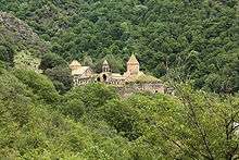
Cultural monuments
Karvachar is rich in important Armenian cultural monuments, close to 750, which include monasteries, churches, chapels, fortresses, khachkars and inscriptions.[3] The most important of them is the monastery of Dadivank.[3]
Under Armenian control
The district was made into the Shahumyan Region, one of the 8 regions of NKR. The region remains the least populated of the NKR regions with a total population of 2,800. The town of Karvachar is home to 500 people.[4]
See also
References
- ↑ "Şəhərlərarası telefon kodları". Aztelekom MMC. Aztelekom İB. Retrieved 19 August 2015. (Azerbaijani)
- ↑ Институт научной информации (Академия наук СССР), Всесоюзный институт научной и технической информации. Реферативный журнал: География, Выпуски 5-6.. — Издательство Академии наук СССР, 1975. — С. 36.
Топоним Кельбаджар (азерб. Кəльбəҹəр) раньше имел форму «Кэблəчəр», состоит из древнетюркского «кевли» — устье реки и «чер» — крепость.
- 1 2 3 4 Robert H. Hewsen, Armenia: A Historical Atlas. The University of Chicago Press, 2001, pp. 40, 101-102, 264-265.
- ↑ Armeniapedia, Karvachar
External links
| Part of the series on |
| Azerbaijan Azərbaycan |
|---|
  |
| Culture |
| History |
| Demographics |
| Geography |
| Administrative divisions |
| Azerbaijan portal |
Coordinates: 40°06′24″N 46°02′18″E / 40.1067°N 46.0383°E