Kamyzyaksky District
| Kamyzyaksky District Камызякский район (Russian) | |
|---|---|
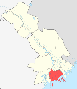 Location of Kamyzyaksky District in Astrakhan Oblast | |
| Coordinates: 46°07′N 48°05′E / 46.117°N 48.083°ECoordinates: 46°07′N 48°05′E / 46.117°N 48.083°E | |
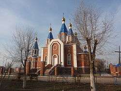 Church in Kamysjak | |
 | |
|
| |
| Location | |
| Country | Russia |
| Federal subject | Astrakhan Oblast[1] |
| Administrative structure (as of June 2015) | |
| Administrative center | town of Kamyzyak[1] |
| Administrative divisions:[1] | |
| Towns of district significance | 1 |
| Urban-type settlements | 2 |
| Selsoviets | 15 |
| Inhabited localities:[1] | |
| Cities/towns | 1 |
| Urban-type settlements[2] | 2 |
| Rural localities | 44 |
| Municipal structure (as of June 2015) | |
| Municipally incorporated as | Kamyzyaksky Municipal District[3] |
| Municipal divisions:[3] | |
| Urban settlements | 3 |
| Rural settlements | 15 |
| Statistics | |
| Area | 3,493 km2 (1,349 sq mi)[4] |
| Population (2010 Census) | 48,647 inhabitants[5] |
| • Urban | 43.5% |
| • Rural | 56.5% |
| Density | 13.93/km2 (36.1/sq mi)[6] |
| Time zone | SAMT (UTC+04:00)[7] |
| Official website | |
| Kamyzyaksky District on WikiCommons | |
| 2010 Census | 48,647[5] |
|---|---|
| 2002 Census | 49,837[8] |
| 1989 Census | 50,336[9] |
| 1979 Census | 49,435[10] |
Kamyzyaksky District (Russian: Камызя́кский райо́н) is an administrative[1] and municipal[3] district (raion), one of the eleven in Astrakhan Oblast, Russia. It is located in the south of the oblast. The area of the district is 3,493 square kilometers (1,349 sq mi).[4] Its administrative center is the town of Kamyzyak.[1] As of the 2010 Census, the total population of the district was 48,647, with the population of Kamyzyak accounting for 33.5% of that number.[5]
References
Notes
- 1 2 3 4 5 6 Law #67/2006-OZ
- ↑ The count of urban-type settlements may include the work settlements, the resort settlements, the suburban (dacha) settlements, as well as urban-type settlements proper.
- 1 2 3 Law #43/2004-OZ
- 1 2 "General Information" (in Russian). Kamyzyaksky District. Retrieved August 31, 2016.
- 1 2 3 Russian Federal State Statistics Service (2011). "Всероссийская перепись населения 2010 года. Том 1" [2010 All-Russian Population Census, vol. 1]. Всероссийская перепись населения 2010 года (2010 All-Russia Population Census) (in Russian). Federal State Statistics Service. Retrieved June 29, 2012.
- ↑ The value of density was calculated automatically by dividing the 2010 Census population by the area specified in the infobox. Please note that this value is only approximate as the area specified in the infobox does not necessarily correspond to the area of the entity proper or is reported for the same year as the population.
- ↑ Правительство Российской Федерации. Федеральный закон №107-ФЗ от 3 июня 2011 г. «Об исчислении времени», в ред. Федерального закона №271-ФЗ от 03 июля 2016 г. «О внесении изменений в Федеральный закон "Об исчислении времени"». Вступил в силу по истечении шестидесяти дней после дня официального опубликования (6 августа 2011 г.). Опубликован: "Российская газета", №120, 6 июня 2011 г. (Government of the Russian Federation. Federal Law #107-FZ of June 31, 2011 On Calculating Time, as amended by the Federal Law #271-FZ of July 03, 2016 On Amending Federal Law "On Calculating Time". Effective as of after sixty days following the day of the official publication.).
- ↑ Russian Federal State Statistics Service (May 21, 2004). "Численность населения России, субъектов Российской Федерации в составе федеральных округов, районов, городских поселений, сельских населённых пунктов – районных центров и сельских населённых пунктов с населением 3 тысячи и более человек" [Population of Russia, Its Federal Districts, Federal Subjects, Districts, Urban Localities, Rural Localities—Administrative Centers, and Rural Localities with Population of Over 3,000] (XLS). Всероссийская перепись населения 2002 года [All-Russia Population Census of 2002] (in Russian). Retrieved August 9, 2014.
- ↑ Demoscope Weekly (1989). "Всесоюзная перепись населения 1989 г. Численность наличного населения союзных и автономных республик, автономных областей и округов, краёв, областей, районов, городских поселений и сёл-райцентров" [All Union Population Census of 1989: Present Population of Union and Autonomous Republics, Autonomous Oblasts and Okrugs, Krais, Oblasts, Districts, Urban Settlements, and Villages Serving as District Administrative Centers]. Всесоюзная перепись населения 1989 года [All-Union Population Census of 1989] (in Russian). Институт демографии Национального исследовательского университета: Высшая школа экономики [Institute of Demography at the National Research University: Higher School of Economics]. Retrieved August 9, 2014.
- ↑ "Всесоюзная перепись населения 1979 г. Национальный состав населения по регионам России. (All Union Population Census of 1979. Ethnic composition of the population by regions of Russia.)". Всесоюзная перепись населения 1979 года (All-Union Population Census of 1979) (in Russian). Demoscope Weekly (website of the Institute of Demographics of the State University—Higher School of Economics. 1979. Retrieved 2008-11-25.
Sources
- Государственная Дума Астраханской области. Закон №67/2006-ОЗ от 4 октября 2006 г. «Об административно-территориальном устройстве Астраханской области», в ред. Закона №32/2015-ОЗ от 3 июня 2015 г. «О преобразовании муниципальных образований и административно-территориальных единиц "Оранжерейнинский сельсовет" и "Федоровский сельсовет" и внесении изменений в отдельные законодательные акты Астраханской области». Вступил в силу по истечении 10 дней со дня официального опубликования. Опубликован: "Сборник законов и нормативных правовых актов Астраханской области", №47, 19 октября 2006 г. (State Duma of Astrakhan Oblast. Law #67/2006-OZ of October 4, 2006 On the Administrative-Territorial Structure of Astrakhan Oblast, as amended by the Law #32/2015-OZ of June 3, 2015 On the Transformation of the Municipal Formations and the Administrative-Territorial Units of "Oranzhereyninsky Selsoviet" and "Fedorovsky Selsoviet" and on Amending Various Legislative Acts of Astrakhan Oblast. Effective as of after ten days from the day of the official publication have passed.).
- Государственная Дума Астраханской области. Закон №43/2004-ОЗ от 6 августа 2004 г. «Об установлении границ муниципальных образований и наделении их статусом сельского, городского поселения, городского округа, муниципального района», в ред. Закона №32/2015-ОЗ от 3 июня 2015 г. «О преобразовании муниципальных образований и административно-территориальных единиц "Оранжерейнинский сельсовет" и "Федоровский сельсовет" и внесении изменений в отдельные законодательные акты Астраханской области». Вступил в силу через 10 дней со дня официального опубликования. Опубликован: "Астраханские известия", №34, 12 августа 2004 г. (State Duma of Astrakhan Oblast. Law #43/2004-OZ of August 6, 2004 On Establishing the Borders of the Municipal Formations and on Granting Them the Status of Rural, Urban Settlement, Urban Okrug, Municipal District, as amended by the Law #32/2015-OZ of June 3, 2015 On the Transformation of the Municipal Formations and the Administrative-Territorial Units of "Oranzhereyninsky Selsoviet" and "Fedorovsky Selsoviet" and on Amending Various Legislative Acts of Astrakhan Oblast. Effective as of the day which is 10 days after the official publication.).
| Cities and towns | ||
|---|---|---|
| Districts | ||
This article is issued from Wikipedia - version of the 10/9/2016. The text is available under the Creative Commons Attribution/Share Alike but additional terms may apply for the media files.