Kanin Peninsula
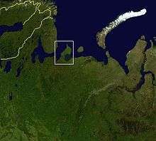
Kanin Peninsula (Russian: Канин полуостров) is a large peninsula in Nenets Autonomous Okrug, Russia. Latitude : 68° Longitude : 45°
It is surrounded by the White Sea to the west and by the Barents Sea to the north and east. Shoyna is one of the few communities on the peninsula.
Fauna
For cetaceans, Beluga whales are most common around. Male Sperm whales are known to occur as well.[1]
Butterflies
A total of 29 butterfly species in the forest-tundra and 14 species in the hypoarctic tundra were recorded on the Kanin Peninsula.[2] The data on the fauna and distribution of species in the forest-tundra of the Kanin Peninsula are generally typical of this natural zone. The most abundant species in the forest-tundra of the Kanin Peninsula are Erebia disa, Oeneis norna, Clossiana freija, Pieris napi, and Vacciniina optilete. The dominant species in southern tundra localities are Erebia Euryale, Erebia pandrose, and Boloria aquilonaris, which coincides with the result of the 1903 research.[3] A high abundance of E. pandrose is a specific feature of the northern part of the Kanin Peninsula and Kolguev Island, pointing to the connection of the biota of these territories with the Subarctic regions of Fennoscandia.
Climate
| Climate data for Cape Kanin Nos | |||||||||||||
|---|---|---|---|---|---|---|---|---|---|---|---|---|---|
| Month | Jan | Feb | Mar | Apr | May | Jun | Jul | Aug | Sep | Oct | Nov | Dec | Year |
| Record high °C (°F) | 4.0 (39.2) |
2.9 (37.2) |
2.4 (36.3) |
9.0 (48.2) |
19.7 (67.5) |
26.3 (79.3) |
30.5 (86.9) |
28.1 (82.6) |
20.4 (68.7) |
12.2 (54) |
10.5 (50.9) |
8.2 (46.8) |
30.5 (86.9) |
| Average high °C (°F) | −6.0 (21.2) |
−6.8 (19.8) |
−5.0 (23) |
−2.4 (27.7) |
1.6 (34.9) |
7.7 (45.9) |
12.0 (53.6) |
10.6 (51.1) |
7.9 (46.2) |
3.6 (38.5) |
−0.5 (31.1) |
−3.5 (25.7) |
1.6 (34.9) |
| Daily mean °C (°F) | −8.2 (17.2) |
−9.5 (14.9) |
−8.2 (17.2) |
−4.7 (23.5) |
−0.7 (30.7) |
4.5 (40.1) |
8.6 (47.5) |
8.6 (47.5) |
5.9 (42.6) |
1.8 (35.2) |
−1.9 (28.6) |
−5.2 (22.6) |
−0.8 (30.6) |
| Average low °C (°F) | −10.7 (12.7) |
−11.4 (11.5) |
−9.2 (15.4) |
−6.4 (20.5) |
−1.9 (28.6) |
2.8 (37) |
6.8 (44.2) |
6.8 (44.2) |
4.7 (40.5) |
0.8 (33.4) |
−3.9 (25) |
−7.6 (18.3) |
−2.4 (27.7) |
| Record low °C (°F) | −31.7 (−25.1) |
−33.1 (−27.6) |
−29.6 (−21.3) |
−30.6 (−23.1) |
−16.7 (1.9) |
−6.5 (20.3) |
−1.9 (28.6) |
−0.7 (30.7) |
−3.1 (26.4) |
−13.4 (7.9) |
−22.4 (−8.3) |
−30.0 (−22) |
−33.1 (−27.6) |
| Average precipitation mm (inches) | 40.8 (1.606) |
29.5 (1.161) |
27.3 (1.075) |
21.3 (0.839) |
21.3 (0.839) |
29.4 (1.157) |
35.8 (1.409) |
47.5 (1.87) |
45.5 (1.791) |
55.0 (2.165) |
45.5 (1.791) |
41.9 (1.65) |
440.8 (17.353) |
| Average precipitation days (≥ 1.0 mm) | 11.1 | 9.0 | 8.6 | 7.3 | 6.5 | 7.2 | 6.2 | 10.0 | 11.3 | 15.4 | 13.5 | 14.2 | 120.3 |
| Average snowy days | 22 | 21 | 21 | 17 | 13 | 5 | 0.4 | 0.3 | 2 | 15 | 21 | 24 | 162 |
| Average relative humidity (%) | 87 | 88 | 88 | 86 | 86 | 86 | 88 | 89 | 88 | 85 | 86 | 87 | 87 |
| Mean monthly sunshine hours | 3.1 | 19.8 | 80.6 | 153.0 | 170.5 | 201.0 | 229.4 | 130.2 | 84.0 | 37.2 | 6.0 | 0.0 | 1,114.8 |
| Source #1: Weatherbase[4] | |||||||||||||
| Source #2: Hong Kong Observatory[5] | |||||||||||||
References
- ↑ http://spo.nmfs.noaa.gov/mfr464/mfr46410.pdf.
- ↑ Bolotov, I. N. (2012). "The Fauna and Ecology of Butterflies (Lepidoptera, Rhopalocera) of the Kanin Peninsula and Kolguev Island". Entomological Review. 92 (3): 296–304. doi:10.1134/S0013873812030062.
- ↑ Poppius, B. (1906). "Beiträge zur Kenntniss der Lepidopteren-Fauna der Halbinsel Kanin". Acta Soc. Fauna Flora Fennica B. 28 (3): 1–11.
- ↑ "Weatherbase: Historical Weather for Kanin Nos, Russia". Weatherbase. Retrieved November 13, 2012.
- ↑ "Climatological Information for Cape Kanin Nos, Russia". Hong Kong Observatory. Retrieved November 13, 2012.
Coordinates: 68°N 45°E / 68°N 45°E