Kaohsiung Station
|
Kaohsiung Railway station | |
| Other names | Kaohsiung Main Station (MRT) |
| Location |
Jianguo 2nd Road, No. 318 Sanmin, Kaohsiung Taiwan |
| Operated by | |
| Line(s) |
|
| Distance | 399.8 km from Keelung |
| Connections | Bus stop |
| Construction | |
| Structure type |
Temporary Station: At-Grade/Underground (Underground station under construction) |
| Disabled access | Yes |
| Other information | |
| Classification | 特等站 (Taiwan Railways Administration level) |
| History | |
| Opened |
TRA: June 22, 1941 (original) March 28, 2002 (temporary) MRT: March 9, 2008 |
| Traffic | |
| Passengers | |
| Kaohsiung Station | |||||||||||
| Traditional Chinese | 高雄車站 | ||||||||||
|---|---|---|---|---|---|---|---|---|---|---|---|
| Simplified Chinese | 高雄车站 | ||||||||||
| |||||||||||
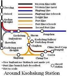
Kaohsiung Station (Chinese: 高雄車站; pinyin: Gāoxióng Chēzhàn) is a railway station located in Sanmin District of Kaohsiung, Taiwan, Republic of China, which serves the Taiwan Railway Administration Western Line, Pingtung Line and the Kaohsiung MRT Red Line. There is a plan to extend Taiwan High Speed Rail from Zuoying to this station.
Overview
TRA Station
The temporary TRA station (opened March 28, 2002) is a three-level aboveground station connected by elevated walkways between train platforms. It is divided into front and back stations. At ground level, there are four island platforms and twelve tracks (previously thirteen tracks). Eight of the tracks are aligned with platforms.
|□||||□||□|||□||
Numbering starts on the left (south side).
Kaohsiung MRT Station

.jpg)
The Kaohsiung MRT station is a two-level, underground station with one exit.[3] It is located at Jianguo 2nd Road.
The entire station is currently undergoing construction as part of a project to move all rail lines through Kaohsiung underground. Though the station is functional, many areas are not operating at full capacity. Kaohsiung Main Station's platform only allows for three-car configurations while all other stations on the Red Line have platforms that can accommodate six-car configurations. Construction is expected to be completed in December 2017.
Layout
| G | Street level | Entrance/Exit |
| B1 | Concourse | Lobby, information desk, automatic ticket machines, one-way faregates Restrooms (Near Exits 3) |
| B2 | Platform 1 | ← KMRT Red Line toward Siaogang (Formosa Boulevard) |
| Platform 2 | → KMRT Red Line toward Gangshan South (Houyi) → | |
History
TRA Station
- 1900: Takau (Chinese: 打狗) station opened with the opening of Tainan-Takau line where the Kaohsiung Harbor Station is today.
- 1907: Hōzan (Japanese: 鳳山) branch (extended to today's Pingtung Line) opened.
- 1920: Takau Station was renamed to Takao (高雄) Station.
- 1933: Construction of new station on Hōzan branch started.
- June 22, 1941: Takao Station (new) opened and old Takao Station was renamed to Takao Harbor Station.
KMRT Station
Nearby stations

- Taiwan Railway Administration (TRA)
- Western Line
- Pingtung Line
- Kaohsiung Mass Rapid Transit
- Red Line
Around the station
- Kaohsiung Old Station
- Sanfeng Temple
- Sanfong Central Street
- Jianguo Rd. Computer Market
- Chang-Gu World Trade Center
- Changming Rd. Clothing, Electronics, and Spare Parts Market
- Kaohsiung Municipal Kaohsiung Senior High School
- Kaohsiung Bus Station
- Kuo-Kaung Motor Transportation Co., Aloha Bus Co., United Bus Co., Ho-Hsin Bus Traffic Co. Stations
- Sankuaicuo Train Station
See also
External links
- Kaohsiung Station (Chinese)
Nearby stations
| Preceding station | Taiwan Railway Administration | Following station | ||
|---|---|---|---|---|
toward Keelung | Western Line Taiwan Trunk Line | Terminus | ||
| Terminus | Pingtung Line | toward Fangliao |
||
| Preceding station | Kaohsiung MRT | Following station | ||
toward Gangshan South | Red Line | toward Siaogang |
References
| Wikimedia Commons has media related to Kaohsiung Station. |
- ↑ "Volume of Passenger and Freight Traffic" (PDF). Taiwan Railway Administration. 2015. Retrieved 2015-05-08.
- ↑ "統計資訊 > 統計月報". Transportation Bureau, Kaohsiung City Government. Retrieved 2011-02-15.
- ↑ "高雄車站". 高雄捷運公司. Retrieved 2010-07-06.
Coordinates: 22°38′24″N 120°18′10″E / 22.64000°N 120.30278°E