Karaburun Peninsula, Albania
| Native name: <span class="nickname" ">Gadishulli i Karaburunit | |
|---|---|
|
Karaburun Peninsula and its highest peak of Koreta (826 m), as seen from the village of Radhima's coasts in Vlorë, Albania | |
 Karaburun Peninsula | |
| Geography | |
| Location | Ionian Sea and Adriatic Sea |
| Coordinates | 40°22′N 19°22′E / 40.367°N 19.367°ECoordinates: 40°22′N 19°22′E / 40.367°N 19.367°E |
| Area | 62 km2 (24 sq mi) |
| Highest elevation | 826 m (2,710 ft) |
| Highest point | Koreta peak |
| Administration | |
|
Albania | |
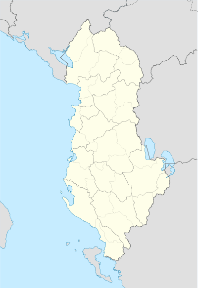
| County | Vlorë |
| Demographics | |
| Population | uninhabited |
Karaburun Peninsula, Albania (Albanian: Gadishulli i Karaburunit, from Turkish Kara Burun, Black Cape) is the largest peninsula of Albania, located in the Vlorë County, southwestern Albania, at the eastern side of the Strait of Otranto, where the Adriatic Sea meets the Ionian Sea. It has an area of 62 km2 (24 sq mi)[1] and has no population. It is 16 kilometres (9.9 mi) long with a width that varies from 3 to 4.5 kilometres (1.9 to 2.8 mi). The peninsula is a Managed Nature Reserve, and contains the Pasha Liman military base. The surrounding sea waters form part of the Karaburun-Sazan National Marine Park.[2] In 2014, the Regina Blu ferry was established by a Radhime-based hotel owner making trips to Karaburun Peninsula and Sazan Island while stopping along the secluded beaches.[3]
Geography
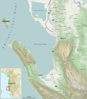
Karaburun peninsula lies southwest of Albania, in the county of Vlorë, whereas the Strait of Otranto separates it from Salento in Italy, by only 72 kilometres (45 mi). It borders with Gulf of Vlorë to the east and the Ionian Sea to the west. In the north, the waters of Mezokanal (or South canal) divide the peninsula from Sazan Island, which is 4.8 km away. On the south, Karaburun peninsula’s border lies on the virtual line that links the extreme south of Vlora's Gulf with Gjiri i Arushës (Bear’s bay) to the west. The highest altitude of the peninsula is Maja e Koretës (Koreta’s peak) 826 m above sea level. Here, a telecommunication antenna tower was erected in recent years. Northwest rises the other prominent peak of the peninsula: Maja e Ilqes 733 m. Southeast of the peaks the terrain lowers to the karstic plateau of Ravena (with altitudes 200–300 m), well known for its wintry pastures. Whereas the offshore margin of the Karaburun peninsula has been investigated down to -200m of water depth, within 4/5 km.[4] The western coast of Karaburun peninsula comprises a rough relief, steep cliffs, caves, small bays and rocky beaches, such as Gjiri i Arushës (Bear's bay), Gjiri i Dafinës (Laurel bay) and 14 km (8.7 mi) southeast of Gjiri i Arushës is located the most interesting Gramata Bay, a small bay where ships and vessels anchored since antiquity. On the high and steep rock faces of the bay, which served also as a marble quarry, there are inscriptions and names of even prominent historical figures that date back to the 4th century BC, such as of Mark Antony[5] and Byzantine emperor John V Palaiologos[6][7] in 1369 on his way to Venice. On the north of the peninsula there's a landmark cape, Kepi i Gjuhëzës, the westernmost point of continental Albania (Sazan Island being the one westernmost point of the country) and the country most famous Haxhi Aliu's cave. The eastern coasts are less rough and slope gradually to the bay of Vlora. From the altitudes of the peninsula, on clear weather, the coasts of Salento and the town of Otranto in Italy can be seen by naked eye.
Geology
Karaburun peninsula is part of the Sazan Zone, which is a constituent of the Albanides tectonic unit. Albanides form the link between Dinarides and Hellenides orogenic belts. They are considered allocthonous and mobilist theories deduce they come from the east.[8] Tectonically, the peninsula consists entirely of Mesozoic Era limestone formations of Cretaceous and Paleogene periods.[9] These formations have been continuously under the effect of Karst and are exploited as marble (metamorphosed limestone) since antiquity.[10] The widespread Karst topography is responsible for the absence of potable water and thus the absence of any population on the peninsula. Despite the dry surface and upper soil layers, there are several water sources that pour deep directly into the sea. The geological evolution has formed also capes such as Galloveci cape and Kepi i Gjuhëzës, as well as a total number of 20 caves along the whole coast.[11]
Ecology
The sea water surrounding the Karaburun peninsula forms the largest marine area of Karaburun-Sazan National Marine Park. Further south to the peninsula lies Llogara National Park. It has a mild Mediterranean climate with hot summers and generally warm to cool, dry winters. Water sources are absent on ground surface. Nevertheless, the fauna is represented by several species, such as the endangered loggerhead sea turtle (Caretta caretta) that nests on the isolated beaches of the western Ionian coasts. Also the Mediterranean monk seal (Monachus monachus) have also been sighted.[12] Vegetation is poor, but there are oak trees on the western side of the peninsula and on the plateau of Ravena (covered with pastures). The eastern side is covered with scattered bushes and pines.[13] The marble found at Grama Bay was used in construction during ancient times, while inscriptions of sailors can be found on its walls. The largest cave of the peninsula is named after Haxhi Aliu, a well known pirate of the time.
Gallery
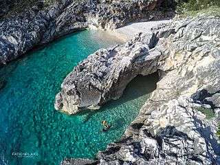 Gjiri i Skalomës
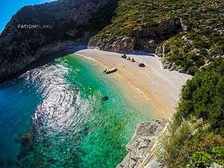 Gjiri Gramës
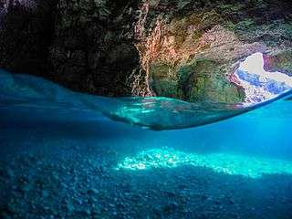 Shpella e Dafinës
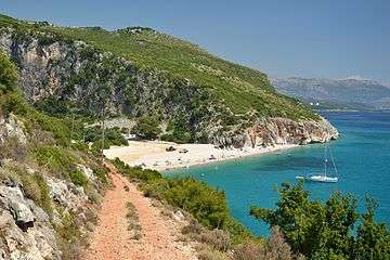 Gjipe Canyon
 Gjiri i Ariut
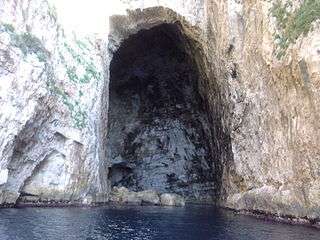 Haxhi Aliu Cave
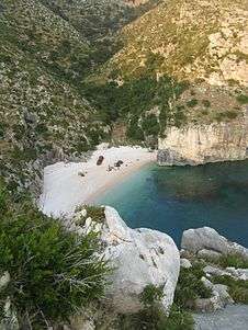 Grama Bay
See also
- Tourism in Albania
- Albanian Riviera
- Geography of Albania
- Karaburun-Sazan National Marine Park
- Sazan Island
- Karaburun tragedy
References
- ↑ The Key of the Albanian Coast, Tirane 2006 (page 139)
- ↑ Proclamation of Karaburun-Sazan as National Marine Park, April 2010
- ↑
- ↑ http://www.cismalbania.it/download/Cism1CruiseReport5.4.pdf
- ↑ Gadishulli i Karaburunit
- ↑ [Fjalori Enciklopedik Shqiptar, Akademia e Shkencave - Tiranē, 1984 (GRAMATA, page 317)]
- ↑ Gramata
- ↑ [Nopcsa, 1929; Nowak 1929]
- ↑ Encyclopedia of European and Asian regional geology By Eldridge M. Moores, Rhodes Whitmore Fairbridge
- ↑ [Fjalori Enciklopedik Shqiptar, Akademia e Shkencave - Tiranē, 1984 (page 455)]
- ↑
- ↑ Lonely Planet Western Balkans - By Marika McAdam (ENVIRONMENT, Wildlife section, page 60)
- ↑ [Fjalori Enciklopedik Shqiptar, Akademia e Shkencave - Tiranē, 1984 (KARABURUNI, page 455)]
External links
| Wikivoyage has a travel guide for Vlorë. |
| Wikimedia Commons has media related to Category:Karaburun Peninsula. |
- Documentary on Karaburun Natural Heritage, ABC News Albania, Youtube (Albanian)
- Consorzio Nazoinale Interuniversitario per le Scienze del Mare - CRUISE REPORT from Bari to Valona (21-31 May 2007) Alessandra SAVINI, Giorgio BUDILLON
| Landmarks |
|
|---|---|
| Transport | |