Kariega River
| Kariega River | |
| Karuiga, Karuka | |
| Country | South Africa |
|---|---|
| Province | Eastern Cape |
| Towns | Kenton-on-Sea |
| Mouth | Indian Ocean |
| - location | Kenton-on-Sea, Eastern Cape, South Africa |
| - elevation | 0 m (0 ft) |
| - coordinates | 33°40′56″S 26°41′00″E / 33.68222°S 26.68333°ECoordinates: 33°40′56″S 26°41′00″E / 33.68222°S 26.68333°E |
| Length | 138 km (86 mi) |
| Basin | 685 km2 (264 sq mi) |
 Location of the Kariega River's mouth | |
Kariega River (Afrikaans: Kariegarivier) is a river located in the Eastern Cape province South Africa. It is an intermittent water course that reaches the ocean through an estuary.[1]
This river rises 24 km west of Grahamstown and gives its name to Kariega Park.
Origin of the name
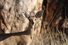
On the strength of other three Kariega rivers being possibly 'Steenbok' rivers it is generally assumed that the same applies here. However, this is not necessarily the case, for there is no record of Steenbok being found anywhere along the length of the river. It is true that cave-paintings said to depict these animals are to be found in the vicinity, but there are numerous instances of animals being depicted in caves situated in habitat entirely unsuited to them. (And in the Swartberg there is a painting of a full-rigged sailing ship, despite the cave being situated more than 100 km from the sea.)
The original inhabitants of much of the Cape were the Khoikhoi. Their descendants are still in the area, but other than in parts of the Northern Cape their languages are no longer spoken. Nonetheless there are still plenty of Khoikhoi words in everyday use in this country. In the Cape Khoikhoi words are most often encountered in the form of place names, examples being Knysna – meaning 'ferns' - a town on the Garden Route, and the Cango Caves – Cango being the Khoikhoi for 'wet mountain'. And, of course, there is Kariega Park, situated beside the Kariega River.
It is uncertain why this particular Kariega River acquired its name, or what it means, but although one will not see a Steenbok occurring naturally in the area of the Kariega Park, the name is typical of the Cape, has connections with the earliest people to inhabit the area, and is the name of one of its most charming and graceful small buck.
Other Kariega Rivers
There are other three Kariega Rivers in the Eastern Cape.
The Kariega and the Beervlei Dam
A Kariega River flows into the Beervlei Dam which is situated north of Willowmore. The name of this river has appeared in a variety of forms, including Karuiga and Karuka and this has led the experts to believe that in this case the Kariega should in fact be one of these earlier forms and that it refers to 'buffalo'. After all the earliest European settlers in the area referred to the river as the Buffels - Buffalo. However, various sources, basing their argument not on linguistics, but on the incidence of the antelope in the vicinity, have stated that the name means 'Steenbok'.
The Kariega and the Sundays River
Then there is the Kariega River that is a tributary of the Sundays River.[2] For much of its length it flows through an area known as the Steenbok Flats, and on which there is a farm named Kariega. Steenbok were frequently found in this area, and are not unknown today. For this reason, and on the strength of linguistics, the experts believe that in this case Kariega does mean Steenbok.
The Kariega and the Great Fish River
The Great Fish River also has as one of its tributaries a Kariega River, the source of which is in the mountains some 20 km north of Somerset East. There are no historical records of Steenbok in this area, but the river flows through countryside that is typical of that favoured by this small buck, so there is no reason to doubt that in this instance Kariega also stands for 'Steenbok'.