Kavrayskiy VII projection

Kavrayskiy VII projection of the Earth.
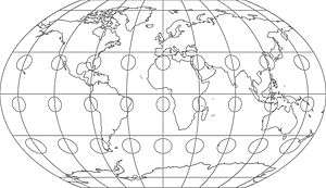
The Kavrayskiy VII projection with Tissot's indicatrix of deformation
The Kavrayskiy VII projection is a map projection invented by Vladimir V. Kavrayskiy in 1939[1] for use as a general purpose pseudocylindrical projection. Like the Robinson projection, it is a compromise intended to produce good quality maps with low distortion overall. It scores well in that respect compared to other popular projections, such as the Winkel Tripel,[2][3] despite straight, evenly spaced parallels and a simple formulation. Regardless, it has not been widely used outside the former Soviet Union.
The projection is defined as:

where λ is the longitude and φ is the latitude in radians.
See also
References
- ↑ Snyder, John P. (1993). Flattening the Earth: Two Thousand Years of Map Projections. Chicago: University of Chicago Press. p. 202. ISBN 0-226-76747-7. Retrieved 2014-11-05.
- ↑ Goldberg, David M.; Gott III, J. Richard (2007). "Flexion and Skewness in Map Projections of the Earth" (PDF). Cartographica. 42 (4): 297–318. doi:10.3138/carto.42.4.297. Retrieved 2014-11-05.
- ↑ Capek, Richard (2001). "Which is the best projection for the world map?". Proceedings of the 20th International Cartographic Conference. Beijing, China. 5: 3084–93. Retrieved 2014-11-05.
External links
| Wikimedia Commons has media related to Maps with Kavrayskiy VII projection. |
- Curvature in Map Projections, quantification of overall distortion in projections.
- Mapthematics Kavrayskiy VII, bivariate distortion map.
- Deducing the Kavrayskiy VII Projection, description of the properties of the Kavrayskiy VII projection.
This article is issued from Wikipedia - version of the 11/6/2016. The text is available under the Creative Commons Attribution/Share Alike but additional terms may apply for the media files.