Kehelgamu Oya
| Kehelgamu Oya | |
|---|---|
 | |
| Basin | |
| Main source | Horton Plains |
| River mouth |
Merges with Maskeliya Oya, forming the Kelani River |
| River system | Kelani |
| Physical characteristics | |
| Length | 50 km (31 mi) |
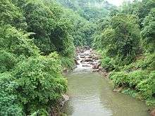
The Kehelgamu Oya (translated into Kehelgamu River from Sinhala) is a major upstream tributary of the Kelani River. The tributary measures 50 km (31 mi) in length, originating from the hills of the Horton Plains National Park, before passing through the Castlereigh Reservoir. Kehelgamu Oya converges with the Maskeliya Oya at Kalugala, forming the 100 km (62 mi) long Kelani River. The river is heavily used for hydroelectric power generation.[1][2]
Features on the river
The following table lists the features along the Kehelgamu Oya, from its origins further upstream. Some dams hold back water, and transfer a percentage of it to hydroelectric power stations located further downstream, via tunnels.
See also
References
- ↑ "Issues of Kelani River Basin" (PDF). EDM.lk. Retrieved 21 January 2014.
- ↑ "CEB Hydropower Generation". Ceylon Electricity Board. Retrieved 18 January 2014.
Coordinates: 06°59′04″N 80°27′36″E / 6.98444°N 80.46000°E
This article is issued from Wikipedia - version of the 6/16/2016. The text is available under the Creative Commons Attribution/Share Alike but additional terms may apply for the media files.