Keinton Mandeville
| Keinton Mandeville | |
 Church of St. Mary Magdalene |
|
 Keinton Mandeville |
|
| Population | 1,068 (2011)[1] |
|---|---|
| OS grid reference | ST545305 |
| District | South Somerset |
| Shire county | Somerset |
| Region | South West |
| Country | England |
| Sovereign state | United Kingdom |
| Post town | Somerton |
| Postcode district | TA11 6 |
| Dialling code | 01458 |
| Police | Avon and Somerset |
| Fire | Devon and Somerset |
| Ambulance | South Western |
| EU Parliament | South West England |
| UK Parliament | Somerton and Frome |
Coordinates: 51°04′19″N 2°39′03″W / 51.0720°N 2.6507°W
Keinton Mandeville is a village and civil parish in Somerset, England, situated 6 miles (9.7 km) west of Castle Cary in the South Somerset district. The village has a population of 1,068.[1] It is next to Barton St David.
Lakeview Quarry specialises in paving and walling stone.
History
At the time of the Domesday Book it was known as Chintone meaning the noble's enclosure from the Old English cyne and tun. The Mandeville part of the village's name came from Stephen de Mandeville around 1243.[2]
The parish was previously called Keinton Mansfield. It was part of the hundred of Catsash.[3]
Governance
The parish council has responsibility for local issues, including setting an annual precept (local rate) to cover the council’s operating costs and producing annual accounts for public scrutiny. The parish council evaluates local planning applications and works with the local police, district council officers, and neighbourhood watch groups on matters of crime, security, and traffic. The parish council's role also includes initiating projects for the maintenance and repair of parish facilities, as well as consulting with the district council on the maintenance, repair, and improvement of highways, drainage, footpaths, public transport, and street cleaning. Conservation matters (including trees and listed buildings) and environmental issues are also the responsibility of the council.
The village falls within the non-metropolitan district of South Somerset, which was formed on 1 April 1974 under the Local Government Act 1972, having previously been part of Langport Rural District.[4] The district council is responsible for local planning and building control, local roads, council housing, environmental health, markets and fairs, refuse collection and recycling, cemeteries and crematoria, leisure services, parks, and tourism.
Somerset County Council is responsible for running the largest and most expensive local services such as education, social services, libraries, main roads, public transport, policing and fire services, trading standards, waste disposal and strategic planning.
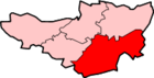
The village is in the 'Northstone' electoral ward. The ward stretches north to Barton St. David and south to Kingsdon. The total population of the ward at the 2011 census was 3,005.[5]
It is also part of the Somerton and Frome county constituency represented in the House of Commons of the Parliament of the United Kingdom. It elects one Member of Parliament (MP) by the first past the post system of election, and part of the South West England constituency of the European Parliament which elects seven MEPs using the d'Hondt method of party-list proportional representation.
Places of interest
- Keinton Mandeville school which provides education for 151 children.[6] In the grounds is a listed dovecote.[7]
- Lake View quarry which is used for the extraction of Blue Lias building stone.[8]
- The Three Old Castles Inn which was built in the late 18th century was a public house but has now closed and is a private house.[9][10] In the High Street is the Quarry Inn.[11]
- Village hall which was built in the 1990s.[12]
- The MUGA (multi use games area) which was built in 2013.[13]
- The high street
Religious sites
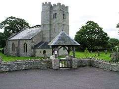
The Church of St. Mary Magdalene dates from the 13th century and has been designated by English Heritage as a grade II listed building.[14]
There is also a Weslyan Methodist Chapel which was built in 1843.[15]
Notable residents
Irving House in Castle Street was the birthplace of actor Henry Irving. It is a Grade II listed building and has a bronze plaque which reads Here was born Henry Irving, Knight, Actor, 6th February 1838.[16]
References
- 1 2 "Statistics for Wards, LSOAs and Parishes — SUMMARY Profiles" (Excel). Somerset Intelligence. Retrieved 4 January 2014.
- ↑ Robinson, Stephen (1992). Somerset Place Names. Dovecote Press. p. 83. ISBN 1874336032.
- ↑ "Somerset Hundreds". GENUKI. Retrieved 8 October 2011.
- ↑ "Langport RD". A vision of Britain Through Time. University of Portsmouth. Retrieved 4 January 2014.
- ↑ "Northstone ward 2011.Retrieved 5 March 2015".
- ↑ "Prospectus" (PDF). Keinton Mandeville Primary School. Retrieved 14 February 2016.
- ↑ "The Old Dovecote in south east corner of grounds to Keinton Mandeville County Primary School". Historic England. Retrieved 14 February 2016.
- ↑ "Report by the Group Manager – Environmental Management: Barry James" (PDF). Somerset County Council. Retrieved 14 February 2016.
- ↑ "The Three Old Castles Inn". National Heritage List for England. Historic England. Retrieved 14 February 2016.
- ↑ "The Three Old Castles, Somerton [Closed] - pub details". Beer In The Evening. Retrieved 19 February 2016.
- ↑ "The Quarry Inn". The Quarry Inn. Retrieved 19 February 2016.
- ↑ "Building the hall". Keinton Mandeville Village Hall. Retrieved 14 February 2016.
- ↑ "Keinton Mandeville MUGA". HAGS SMP. Retrieved 14 February 2016.
- ↑ "Church of St. Mary Magdalene". Images of England. English Heritage. Retrieved 23 September 2008.
- ↑ "Wesleyan Methodist Chapel". National Heritage List for England. Historic England. Retrieved 14 February 2016.
- ↑ "Irving House, Keinton Mandeville". Historic England. Retrieved 1 November 2015.
External links
| Wikimedia Commons has media related to Keinton Mandeville. |