Kellerwald-Edersee National Park
| Kellerwald-Edersee National Park | |
|---|---|
 | |
| Nearest city | Bad Wildungen, Frankenau, Frankenberg, Fritzlar, Korbach, Waldeck |
| Coordinates | 51°09′58″N 9°00′00″E / 51.166°N 9.0°ECoordinates: 51°09′58″N 9°00′00″E / 51.166°N 9.0°E |
| Area | 57.38 km² (5738 ha) [1] |
| Established | 1 January 2004 |
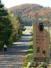
National park sign near Hemfurth-Edersee
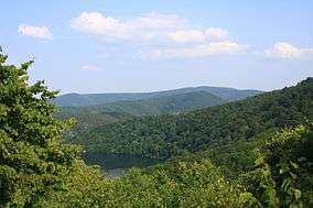
The Kellerwald-Edersee National Park (German: Nationalpark Kellerwald-Edersee), CDDA-No. 318077)[2] in the North Hessian county of Waldeck-Frankenberg is a national park, 57.38 km²[1] in area, that lies south of the Edersee lake in the northern part of the low mountain range of the Kellerwald in the German state of Hesse. Since 25 June 2011 the beech forested area of the national park has been part of the UNESCO World Heritage Site known as Primeval Beech Forests of the Carpathians and the Ancient Beech Forests of Germany.
The national park administration is located in the east of the park at Bad Wildungen.
Literature
- Norbert Panek (2006) (in German), Urwald-Ängste. Der beschwerliche Weg zum Nationalpark "Kellerwald". Idee, Konzept, Entstehungsgeschichte, Korbach: Selbstverlag, ISBN 978-3-00-020673-3
- Norbert Panek (2006) (in German), Nationalpark-Region Kellerwald-Edersee. Mit Kellerwaldsteig, Niedenstein: Cognito, ISBN 978-3-932583-21-6
- Manfred Delpho; Wolfgang Lübcke (2006) (in German), Im Reich der urigen Buchen. Nationalpark Kellerwald-Edersee, Niedenstein: Cognitio, ISBN 978-3-932583-18-6
- Hugo Hücker; Gerhard Kalden (2004) (in German), Naturpark und Nationalpark Kellerwald-Edersee. Faszination Natur, Niedenstein: Cognitio, ISBN 3-932583-12-4
Film
- Im Nationalpark Kellerwald-Edersee, documentary, 45 minutes, Germany, 2005, Buch und Regie: Ina Knobloch, Manfred Praxl und Hiltrud Jäschke, Produktion: MDR
Footnotes and references
- 1 2 National Park Area [5,738 ha (57.38 km²)]: Verordnung über den Nationalpark Kellerwald-Edersee, dated 17 December 2003 in the edition dated 20 December 2010, see § 1 – Erklärung zum Nationalpark, p. 2, (3), at nationalpark-kellerwald-edersee.de (pdf; 1.3 MB)
- ↑ Map services of the Federal Agency for Nature Conservation
External links
| Wikimedia Commons has media related to Nationalpark Kellerwald-Edersee. |
- Official website of the National Park
- Official website of the Kellerwald National Park Centre
- Official website of Edersee Touristic
- Foundation for the Nationalpark Kellerwald-Edersee e.V.
- Sheep project by the National Park Sheepery
- Schaurig ist das falsche Wort, Frankfurter Allgemeine Zeitung, 31 August 2008
- Nationalpark Kellerwald-Edersee radio broadcast hr4, 10 July 2013
| North Germany | ||
|---|---|---|
| Central Germany | ||
| South Germany | ||
This article is issued from Wikipedia - version of the 11/19/2016. The text is available under the Creative Commons Attribution/Share Alike but additional terms may apply for the media files.