Schleswig-Holstein Wadden Sea National Park
| Schleswig-Holstein Wadden Sea National Park | |
|---|---|
| Nationalpark Schleswig-Holsteinisches Wattenmeer | |
|
IUCN category II (national park) | |
|
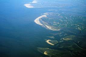
Aerial photo of Trischen, Eiderstedt and the southern North Frisian barrier islands | |
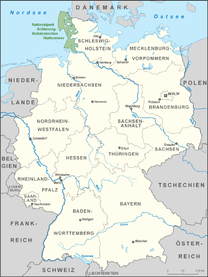 The park is located in northern Germany | |
| Location |
North Sea coast, Schleswig-Holstein, |
| Nearest city | Westerland, Husum. Tönning. Heide |
| Coordinates | 54°27′23″N 8°38′47″E / 54.456302°N 8.646408°ECoordinates: 54°27′23″N 8°38′47″E / 54.456302°N 8.646408°E |
| Established | October 1, 1985 |
| Visitors | 1,746,293 (in 2002) |
The Schleswig-Holstein Wadden Sea National Park (German: Nationalpark Schleswig-Holsteinisches Wattenmeer) is a national park in the Schleswig-Holstein area of the German Wadden Sea. It was founded by the Parliament of Schleswig-Holstein on 1 October 1985 by the National Park Act of 22 July 1985 and expanded significantly in 1999. Together with the Lower Saxon Wadden Sea National Park, the Hamburg Wadden Sea National Park and those parts of Elbe estuary which are not nature reserves, it forms the German part of the Wadden Sea.
The national park extends from the German-Danish maritime border in the north down to the Elbe estuary in the south. In the North Frisian area, it includes the mudflats around the geest-based and marsh islands and the Halligen (undyked islands). There the mudflats are 40 km wide in places. Further south lie areas of mudflats which contain particularly large sandbanks. In addition to the plants and animals that are typical of the entire Wadden Sea, especially large numbers of porpoise, shelduck and eelgrass may be seen in the Schleswig-Holstein part.
With an area of 4410 km ² it is by far the largest national park in Germany. Some 68% of its area is permanently under water and 30% is periodically dry. The land element consists mainly of salt marshes. Since 1990, the national park, including the North Frisian Halligen, has been designated as a UNESCO recognised biosphere. Together with other German and Dutch Wadden Sea areas it became a UNESCO World Heritage Site on 26 June 2009.
Geography
National park area
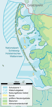
The national park covers an area from the North Sea coast of Schleswig-Holstein by the Danish border in the north to the Elbe estuary in the south. In the northern area (roughly as far as Amrum), the national park boundary extends to the twelve mile territorial limit; to the south it reaches to about the three mile line. On the land side it runs in the sea 150 metres off the coast.[1] Sea dykes and the foreland immediately in front of the dykes are not part of the national park; beaches are thus largely excluded from the protected zone.[2] Also excluded from the national park are the inhabited areas in the sea, including the five German North Frisian Islands and the larger Halligen islands of Langeness, Hooge, Gröde, Oland and Nordstrandischmoor. Part of the park comprises uninhabited islands, islets and Halligen, such as Trischen, Blauort or the North Frisian Barrier Island. Under the classification of the natural regions of Germany the national park area belongs to the "Schleswig-Holstein Wadden Sea, Islands and Halligen" region [3] within the Schleswig-Holstein Marshes, and to the major unit of the German Bight.
The national park can be divided into two areas. In the north, between the Danish border and the peninsula of Eiderstedt is the North Frisian part; on the south coast of Eiderstedt up to the Elbe estuary is the Dithmarschen part. The North Frisian Wadden Sea, together with the Danish Wadden Sea, belongs to the North Sea. It is screened from the open sea by the North Frisian Islands and the Halligen. The islands were mainly formed from elements of the mainland, which became separated, mainly as a result of flood disasters. The mudflats are protected and the transition between the flats and the sea is often clearer, because the former lie to the east of the large islands and the latter to the west of them. There are no major river estuaries and the tidal range is relatively low at less than two metres. In the northern Wadden Sea there are still geest cliffs formed in the ice ages, so that the highest elevations occur here on the coast in an otherwise very flat area. The Dithmarschen part and the south coast between the Elbe and Eider Eider estuaries form the central part of the Wadden Sea. A tidal range of over three metres has largely prevented the formation of islands. Some sandbars emerge from the sea, but only Trischen is high enough and safe enough from storm surges, to allow saltwater-loving vegetation to grow. Compared to the geologically similar East Frisian Islands of the southern Wadden Sea, Trischen is considerably smaller and younger. All attempts by human inhabitants to fortify the island have failed. With several large estuaries the salinity in the central Wadden Sea is lower than in the rest of the Wadden Sea and is subject to higher fluctuations.[4]
See also
Literature
- Common Wadden Sea Secretariat (CWSS) (Hrsg.): Nomination of the Dutch-German Wadden Sea as World Heritage Site. 2008 als PDF
- Landesamt für den Nationalpark Schleswig-Holsteinisches Wattenmeer (Hrsg.): Wattenmeermonitoring 2000 – Schriftenreihe des Nationalparks Schleswig-Holsteinisches Wattenmeer, Sonderheft, Tönning 2001
- Landesamt für den Nationalpark Schleswig-Holsteinisches Wattenmeer (Hrsg.): SÖM-Bericht 2008 als pdf
- Landesamt für den Nationalpark Schleswig-Holsteinisches Wattenmeer / Landesamt für den Nationalpark Niedersächsisches Wattenmeer / Umweltbundesamt (Hrsg.): Umweltatlas Wattenmeer. Bd. 1 (Nordfriesisches und Dithmarscher Wattenmeer), Verlag Ulmer, Stuttgart, ISBN 3-8001-3492-6
- Ministerium für Landwirtschaft, Umweltschutz und Ländliche Räume des Landes Schleswig-Holstein (MLUL) (Hrsg.): Bericht zur Überprüfung des Biosphärenreservats Schleswig-Holsteinisches Wattenmeer und Halligen durch die UNESCO. Berichtszeitraum 1990 bis 2005. Juni 2005 als pdf
- Dirk Legler: Die Organisation deutscher Nationalparkverwaltungen. Nomos, Baden-Baden 2006, ISBN 3-8329-1978-3
- Martin Stock et al.: Salzwiesen an der Westküste von Schleswig-Holstein 1986–2001. Boyens Buchverlag, Heide 2005, ISBN 3-8042-0703-0
Filmography
- Im Nationalpark Wattenmeer. Documentary, 45 min., Germany, 1998, by Jens-Uwe Heins and Michael Sutor, Production: Komplett-Media-GmbH, Grünwald (ISBN 3-89672-492-4), Brief description by the ARD
External links
| Wikimedia Commons has media related to Schleswig-Holstein Wadden Sea National Park. |
- Official website (German)
- Wadden Sea Conservation Station (German)
References
- ↑ Legler, pp. 189–208
- ↑ Rudolf Eugen Kelch: Viel Lärm um nichts oder wie Schleswig-Holstein sein Nationalparkgesetz novelliert als pdf
- ↑ http://www.bfn.de/0311_landschaft.html?landschaftid=68000
- ↑ CWSS S. 19–30
| North Germany | ||
|---|---|---|
| Central Germany | ||
| South Germany | ||