Karak Governorate
| Karak Governorate (محافظة الكرك) | |
| Governorate | |
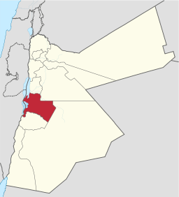 Karak Governorate within Jordan. | |
| Country | Jordan |
|---|---|
| Cities | Mu'tah, Rabba, Qatraneh |
| Capital | Al Karak |
| Area | 3,495 km2 (1,349 sq mi) |
| Population | 249,100 (2012) |
| Density | 71.3/km2 (185/sq mi) |
| Timezone | UTC+2 |
| - summer (DST) | +3 |
| Area code | +(962)3 |
Karak (Arabic: الكرك) is one of the governorates of Jordan, located south-west of Amman, Jordan's capital. Its capital is Al Karak. It borders Madaba and the Capital governorates to the north, Ma'an Governorate from the east, Tafilah Governorate from the south, and the Dead Sea form the west.
History
Ancient history
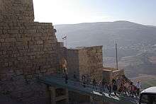
The land of Karak Governorate was the home of the Kingdom of Moab, during the first millenium BC. Their capital and stronghold is believed to be near the city of Al Karak, which was known as the Qir of Moab.
For a brief period of time, the land of Karak Governorate came under Persian rule, and then the Nabateans took control of it, until the Romans invaded the Levant region and occupied their capital, Petra. After the coming of the Byzentines, they established a vassal state ruled by the Ghassanids. The city of Mu'tah was the site of the first clash between the Muslim Arabs and the Byzantine Empire at the Battle of Mu'tah in 629 AD.
With the coming of the crusaders, the Principality of Kerak was established, after which Kerak was a center front between the Ayyubids and the crusaders.
Modern history
From the 15th century until 1917, Karak was under Ottoman rule, then the Emirate of Transjordan. After the creation of the administrative governorates system in the Hashemite Kingdom of Jordan, Kerak Became a governorate on June 16, 1966, with Waheeb Al-Bitar as its first governor.
Geography
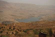
The land of Karak Governorate is situated along the south eastern coast of the Dead Sea and the mountain chain known as the Mountains of Moab. Wadi Mujib, biblically known as Arnon River, flows through the mountains of Karak Governorate and ends in the Dead Sea. The cities in the governorate are located at elevations ranging from over 1000 meters above sea level in the South Mazar Department to 800 meters above sea level in the northern departments to about 330 meters below sea level at Ghor Al-Safi Department. The governorate is connected to the rest of Jordan by two highways:
- Highway 65, also known as the Kings Highway
- Highway 15, also known as the Desert Highway
Demographics
In 2004, according to the Jordan National Census of that year, the population of the Karak Governorate was 204,185, i.e. 4% of the population of Jordan. The male-to-female ratio was 50.6 to 49.4, Jordanian citizens made up 95.42% Among the Jordanian citizens the male-to-female ratio was 50.38 to 49.62. Of the non-Jordanians, the male-to-female ratio was 55.19 to 44.81. The estimated population as of 2010 is about 239,000.[1][2] The next census is scheduled for 2014
| Demographics of Karak Governorate | 2004 Census [3] | 2010 Estimate |
|---|---|---|
| Female to Male ratio | 49.4% to 50.6% | 49.4% to 50.6% |
| Jordanian citizens to foreign nationals | 95.42% to 4.58% | NA |
| Urban population | 34.78% | 35% |
| Rural population | 65.22% | 65% |
| Total population | 204,185 | 238,600 |
Education
Mutah University is the only university in the governorate, located in the city of Mu'tah, and is one of the largest universities in Jordan by number of students.[4]
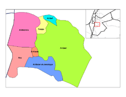
Administrative departments
Karak Governorate is divided into 10 departments according to article 7 of the 46th Administrative Divisions System of 2000:
| Departments of Karak Governorate by population (2004 census) | ||||||||||
|---|---|---|---|---|---|---|---|---|---|---|
|
Department | Arabic name | Areas | Population [5] | Administrative Center |
| ||||
| 1 | Capital Department (Al-Qasabah) | لواء قصبة الكرك | includes the city of Al Karak and 35 other towns and villages | 64,850 | Al Karak | |||||
| 2 | South Mazar Department | لواء المزار الجنوبي | includes 30 towns and villages | 57,191 | Mu'tah | |||||
| 3 | South Aghwar Department | لواء الاغوار الجنوبية | includes seven towns and villages | 32,446 | Safi | |||||
| 4 | Al-Qasr Department | لواء القصر | includes nine towns and villages | 20,860 | Rabba | |||||
| 5 | Ghor Al-Mazra'a Department | قضاء غور المزرعة | includes six towns and villages | 12,743 | Ghor Al-Mazra'a | |||||
| 6 | Faqou' Department | لواء فقوع | includes six towns and villages | 12,178 | Faqou' | |||||
| 7 | Aii Department | لواء عي | includes four towns and villages | 9,711 | Aii | |||||
| 8 | Moab Department | قضاء مؤاب | includes five towns and villages | 9,692 | Husseiniya | |||||
| 9 | Qatraneh Department | لواء القطرانة | includes four towns and villages | 6,949 | Qatraneh | |||||
| 10 | Moujeb Department | قضاء الموجب | includes five towns and villages | 5,818 | Mugheer | |||||
| Source: وزارة الداخلية - الأردن Jordanian ministry of interior | ||||||||||


References
- ↑ http://www.sabeq-jordan.org/SABEQ_Public/sabeq_public_master_Arabic.aspx?Site_Id=5&Page_Id=759 Al-Karak
- ↑ DoS Jordan
- ↑ Jordan National Census of 2004 Table 3-1
- ↑ Mutah University
- ↑ 2004 census
 |
Madaba Governorate | Amman Governorate | | |
| |
|
Ma'an Governorate | ||
| ||||
| | ||||
| Tafilah Governorate |
| North Region |  | |
|---|---|---|
| Central Region | ||
| South Region | ||
Coordinates: 31°09′53″N 35°45′43″E / 31.16472°N 35.76194°E