Kerikeri River (Waikato)
This article is about Kerikeri River, in Waikato, New Zealand. For the river in Northland, New Zealand, see Kerikeri River.
| Kerikeri River | |
|---|---|
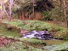 Rapids beside Ruakiwi Rd | |
| Country | New Zealand |
| Basin | |
| Main source | 170 metres (560 ft) |
| River mouth |
Raglan Harbour 0 m (0 ft) |
| Physical characteristics | |
| Length | 9 km (5.6 mi) |
The Kerikeri River is a short river of the Waikato Region of New Zealand's North Island. It flows into the northern shore of Raglan Harbour.
The valley is largely along the line of the fault on the eastern edge of Whaingaroa Harbour. It flows over Coleman Conglomerate and, at its lower end, blue-grey Puti Siltstone, both of Puaroan age (about 150 million years ago).[1]
From about 1870 Sam and Tom Wilson ran a flax mill powered by a wheel in the river.[2] Much of the native bush was cleared for farming between 1910 and 1920.[3]
See also
References
- ↑ Geology of the Raglan-Kawhia Area: Institute of Geological & Nuclear Sciences (N.Z.), Barry Clayton Waterhouse, P. J. White 1994 ISBN 0-478-08837-X
- ↑ page 63 Te Uku: R T Vernon 1975
- ↑ Off the Sheep's back: Bill Richards 1986
External links
- 1:50,000 map at NZ Topomaps
- 1955 Waingaro Landing aerial photo - the foreground shows part of the Kerikeri River arm of the harbour, which is over 3km long. The Waingaro River joins the estuary in the middle left of the photo.
- 2012 Estuarine Vegetation Survey - page 15 describes the wildlife in the Kerikeri River arm of the harbour.
Coordinates: 37°43′S 174°56′E / 37.717°S 174.933°E
This article is issued from Wikipedia - version of the 11/7/2016. The text is available under the Creative Commons Attribution/Share Alike but additional terms may apply for the media files.