Waingaro River (Waikato)
| Waingaro River | |
|---|---|
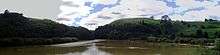 Waingaro Landing and mangroves at mouth of Waingaro River | |
| Country | New Zealand |
| Basin | |
| Main source | 150 m (490 ft) |
| River mouth |
Raglan Harbour 0 m (0 ft) |
| Basin size | 123 km2 (47 sq mi) |
| Physical characteristics | |
| Length | 18 km (11 mi) |
The Waingaro River is a river of the Waikato region of New Zealand's North Island. It flows generally southwest from its origins west of Ngaruawahia to reach a northern arm of Raglan Harbour (see 1:50,000 map). Its main tributary is Kahuhuru Stream, which Highway 22 follows for several kilometres. Tributaries total about 170 kilometres (110 mi).[1]
The Waingaro River is one of the largest sources of sediment in Whaingaroa Harbour, partly because it is 99 percent unfenced.[2]
Geology
The lower river flows over Puaroan age (about 150 million years ago), blue-grey Puti siltstone.[3]
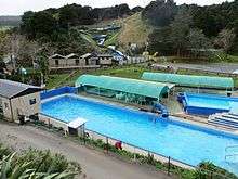
Waingaro Hot Spring was closed in 2014,[4] until improvements were made and it reopened in 2016.[5] It has dilute alkaline NaCl-type (salty), 37 to 54 °C (99 to 129 °F),[6] thermal water flowing from early Jurassic basement rocks at about 350 litres (92 US gal) per minute,[7] probably originating at least 3 kilometres (2 mi) deep.[8]
In 1921 this description was given:
Waingaro/ on the coach-road from Ngaruawhahia to the west coast, has waters of the most strictly simple 'thermal' type, containing only 22 grains of solids to the gallon. It is not a 'spa,' though it is used locally and had at one time a great reputation among the Maoris. The outflow of water is very large and the temperature high. There is a large simple immersion bath, with hotel accommodation alongside.ANALYSIS Grains per gallon.
- Sodium chloride 6-43
- Silica 7-80
- Total solids 22-66
- Temperature. 130 °F.[9]
In 1942 a corrugated iron shelter, which had covered the spring on the north side of the road, was swept away by a flood. After that the hot water was piped under the road and the present complex of baths built.[10]
| Spring | Date sampled | TD°C | pH(20 °C) | Li | Na | K | Ca | Sr | Ba | B | HCO3 | SiO2 | SO4 | F | Cl | I | ΔD ‰ | δ18O ‰ | T (SiO2) °C |
|---|---|---|---|---|---|---|---|---|---|---|---|---|---|---|---|---|---|---|---|
| Waingaro well | 12/05/2005 | 54.7 | 9.2 | 0.05 | 79 | 0.73 | 1.2 | 0.005 | 0.0004 | 4.9 | 44 | 55 | 8.3 | 3.5 | 49 | 0.029 | -31.5 | -5.74 | 83 |
Waingaro Landing
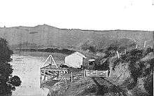

The narrow, 2 km (1.2 mi) gravel road from Ohautira Rd to the boat ramp and whitebait stands at Waingaro Landing now sees little traffic, but was once much more important.
Just south of the point where the Waingaro joins the Kerikeri River, there is a record of Waingaro Landing being used by Rev A N Brown in 1834 to travel from Bay of Islands to Kawhia.[12] Little changed for another half century.
About 1883 a Crown Grant of 1,000 acres (400 ha) on the banks of the Waingaro stream was taken on by M. Barton or Patene, then Mr Clarke, then by Sam Picken. Most of it was in heavy bush. Clarke had started clearing it, employing Arthur Moon and Johnnie Douglas.[13] Picken travelled to Huntly by train, crossing the Waikato by boat, then rode on a bridle track to Glen Afton and finally on a native track through heavy bush of rimu and matai on the hills, and kahikatea on the flats. Within a year the native track had been turned into a bridle track.[12] Picken was joined by George Richards, Arthur Shilson, Ned Edmonds, Stevens, Arthur Richards and Pyne. The Crown then built a road from Ngaruawahia to the landing. By 1893 most land had been bought, except 600 acres (240 ha) at the Hot Springs on a 21 year lease to Sam Wilson, who built the hotel.[13]
Charles Sutton bought the 30 ft (9.1 m) steam launch 'Vesta', which could tow a punt from Raglan to Waingaro in one hour. An experiment with the 40 ft (12 m) 'Amateur' was unsuccessful; it took 3 hours. In 1896 the 'Vesta' was repaired and took on the work again.[14]
For almost two decades the landing became a popular route to Raglan, when Captain Coge ran the S.S. 'Maori' between Raglan and the landing from 1903.[15] A coach from Ngaruawahia brought mail and passengers.[16]
About 1903, the Ministry of Tourist and Health Resorts published these options for journeys from Auckland to Raglan:
- Auckland to Ngaruawahia, 74 mi (119 km): Depart rail Auckland 10 a.m.
- Arrive Ngaruawahia, 12.58 p.m. 1st class 8/10, 2nd 5/9.
- Ngaruawahia to Waingaro, 16 mi (26 km). Coach departs Tuesday and Friday, 1.15 p.m. arrives 4 p.m. 6/- single, 10/- return.
- Waingaro to Raglan, 9 mi (14 km). Oil launch Tuesday and Friday. 2/6 single, 4/- return.
- Raglan to Onehunga 115 mi (185 km). N.S.S. (Northern Steamship) Steamer weekly. 20/- single, 30/- return. Saloon.
- Onehunga to Auckland, 8 mi (13 km). Rail frequently. First I/-, 2nd 9 pence.
- Raglan to Hamilton, 35 mi (56 km). Coach M.W. and Fridays. Departs 7 a.m. Arrives 1.10 p.m.
- Hamilton to Raglan. Coach Tues., Thurs., and Saturdays. Depart Hamilton 9 a.m. Arrives 4 p.m. Single 12/-, return 20/-.
Coge soon gave up the boat service,[17] but by 18 November 1904 the Raglan Chronicle was advertising for cargo for the launch 'Nita' after 7 local men formed the co-operative, Raglan Launch Co, to take over, with land agent, A. R. Langley, as secretary.[18] With Mr B. Vercoe in charge, she continued trading until a fire in March, 1909,[12] with Frank Charlton in charge. However, the fire seems to have been extinguished[19] and the 'Nita' was later bought by Billy McQueen, who traded round the harbour till about 1920.[14] From time to time the Post Office invited tenders to carry mail on the route.[20] The County Council agreed to extend the shed and wharf in 1910, though not buy extra land for it.[21] The work was completed in 1913.[22]
The road to the landing was still being improved in 1905, when ₤100 was allocated.[23]
After 1920[12] the mail coach was replaced by a cream truck run by Bob Gibb on a Ngaruawahia-Te Akau mail run.[24]
See also
References
- ↑ Land Air Water Aotearoa
- ↑ Regional Council report on Whaingaroa Harbour Care
- ↑ Geology of the Raglan-Kawhia Area: Institute of Geological & Nuclear Sciences (N.Z.), Barry Clayton Waterhouse, P. J. White 1994 ISBN 0-478-08837-X
- ↑ Council closure notice
- ↑ "March 2016: Waingaro Hot Pools open". www.raglan23.co.nz. Retrieved 2016-03-13.
- ↑ list of hot pools, temperatures, flow rates, etc in Geothermal Resources In New Zealand An Overview: Trevor M. Hunt, Wairakei Research Centre, Institute of Geological & Nuclear Sciences Ltd 1998
- ↑ Geological Survey Professional Paper, Volume 492 1965 page 242
- ↑ Naike Hot Springs: A Hot Spring System (N Island, New Zealand) S. Siswojo, A.S. Kasonta, M.P. Hochstein Geothermal Institute, University of Auckland 1985
- ↑ The Hot Springs of New Zealand: Arthur Stanley Herbert 1921
- ↑ The End of an Era: Gwyneth Jones 2010
- ↑ Journal of Volcanology and Geothermal Research 2010 - Sources of solutes and heat in low-enthalpy mineral waters and their relation to tectonic setting, New Zealand: A.G. Reyes, B.W. Christenson, K. Faure
- 1 2 3 4 Raglan County Hills and Sea 1876-1976. Wilson & Horton for Raglan County Council. 1976. pp. 33, 132, 152, 153.
- 1 2 Vernon, R. T. (1981). Around Raglan. pp. 69–70.
- 1 2 Vernon, R. T. (1984). Raglan. Rice. pp. 24, 25, 126.
- ↑ "Local And General News.". New Zealand Herald. 1903-08-07. pp. 4 5. Retrieved 2015-12-30.
- ↑ "Local And General News.". New Zealand Herald. 1903-08-07. pp. 4 5. Retrieved 2015-12-30.
- ↑ "News From Waingaro.". New Zealand Herald. 1904-09-06. p. 3. Retrieved 2015-12-30.
- ↑ "advert - Nita will run to Waingaro and Te Uku 6s per ton". Raglan County Chronicle. 19 November 1904.
- ↑ "Raglan.". Waikato Argus. 1909-03-16. p. 2. Retrieved 2015-12-30.
- ↑ "Page 20 Advertisements Column 2". Observer. 1909-09-18. p. 20. Retrieved 2015-12-30.
- ↑ "Raglan County Council.". Waikato Argus. 1910-01-21. p. 2. Retrieved 2015-12-30.
- ↑ "Raglan County Council.". Waikato Times. 1913-01-15. p. 4. Retrieved 2015-12-30.
- ↑ "The Supplementary Estimates.". New Zealand Herald. 1905-10-31. p. 6. Retrieved 2016-01-01.
- ↑ Richards, Bill (1986). Off the Sheep's Back. Lindon Pub. p. 87. ISBN 0864700148.
- "Place Name Detail: Waingaro River (Waikato)". New Zealand Geographic Placenames Database. Land Information New Zealand. Retrieved 12 July 2009.
- New Zealand 1:50000 Topographic Map Series sheet BD32 – Raglan
External links
| Wikimedia Commons has media related to Waingaro River (Waikato). |
- most of the river is close to Ohautira and Waingaro Roads, so many images are available in street scene on https://maps.google.com/
- water quality at Ruakiwi Rd
- water level at Waingaro
- , , - National Library 1910 photos of Waingaro Landing, Waingaro Bay (note the 1900 road to the Landing on the hillside) and Waingaro Estuary.
- 1955 Waingaro Landing aerial photo - the foreground shows part of the Kerikeri River arm of the harbour, which is over 3km long. The Waingaro River joins the estuary in the middle left of the photo.
- Photo of oil launch 'Nita'.
- 2012 Estuarine Vegetation Survey - page 15 describes the wildlife in the Waingaro and Kerikeri River arm of the harbour.
- New Zealand Herald 17 June 1893 - description of hot springs and their history.
Coordinates: 37°44′36″S 174°57′30″E / 37.74333°S 174.95833°E