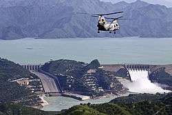
Khalabat Township
| Khalabat Township Tarbela Lake | |
|---|---|
| Town and union council | |
|
| |
| Coordinates: 34°13′N 73°02′E / 34.217°N 73.033°ECoordinates: 34°13′N 73°02′E / 34.217°N 73.033°E | |
| Country |
|
| Region | Khyber Pakhtunkhwa |
| District | Haripur District |
| Time zone | PST (UTC+5) |
| Website | Khalabat Township |
'Khalabat, Khalabut, Tarbela Colony,' Khalabat Township, or Tarbela Township, is one of the 30 union councils of Haripur District in the Khyber Pukhtoonkhwa of Pakistan. The administrative division is some 65 km (40 mi) north of Islamabad and 35 km (22 mi) south of Abbottabad. Covering a hilly plain area, the township comprises four sectors and two Union Councils: Tarbela Union Council has sector 1 and 2, and Khalabat Union Council has sector 3 and 4.[5]
Location
The elevation is 1,440 feet (439 m). It is located on the way from Haripur to Tarbela Lake (see external image).[6]
History
Khalabat Township was established northeast of the district Haripur, between the city of Haripur city and Tarbella Lake, when over 135 villages with 96,000 people were flooded, due to the construction of Tarbela dam. Residential construction started in 1974, according to an urban plan prepared by the Water and Power Development Authority of Pakistan. The layout design of Khalabat township is similar to sectors of Islamabad.
References
- ↑ "Tarbela Lake". BeautifulPakistan.com. Retrieved 2012-08-22.
- ↑ "Tarbela Lake Pictures - Tarbela Lake Photos, Pakistan". http://khalabat-township.blogspot.com/. Retrieved 2012-08-22. External link in
|publisher=(help) - ↑ "Tarbela Lake". BeautifulPakistan.com. Retrieved 2012-08-22.
- ↑ "Tarbela Lake Pictures - Tarbela Lake Photos, Pakistan". http://khalabat-township.blogspot.com/. Retrieved 2012-08-22. External link in
|publisher=(help) - ↑ "Tehsils & Unions in the District of Haripur", NRB.gov.pk.
- ↑ "Photo of Tarbela Lake". Retrieved 30 August 2011.
