Khoy
| Khoy خوی | |
|---|---|
| city | |
|
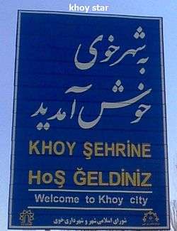
Welcome to Khoy | |
 Khoy | |
| Coordinates: 38°33′01″N 44°57′08″E / 38.55028°N 44.95222°ECoordinates: 38°33′01″N 44°57′08″E / 38.55028°N 44.95222°E | |
| Country |
|
| Province | West Azerbaijan |
| County | Khoy |
| Bakhsh | Central |
| Government | |
| • Mayor | Moharram Akbarzadeh |
| • Parliament | Kabiri |
| Elevation[1] | 1,148 m (3,769 ft) |
| Population (2012[2]) | |
| • Total | 200,985 & 354,309 |
| City & County | |
| Time zone | IRST (UTC+3:30) |
| • Summer (DST) | IRDT (UTC+4:30) |
| Area code(s) | 0461 |
| Website | khoycity.ir |
Khoy (Azerbaijani: خوی; Persian: خوی; also Romanized as Khoy and Khoi),[3] is a city in and the capital of Khoy County, West Azerbaijan Province, Iran. At the 2012 census, its population was 200,985. Khoy is biggest city in the Azerbaijan region that is not capital of Province.
Khoy is located north of the province's capital and largest city Urmia, and 807 km north-west to Tehran. The region's economy is based on agriculture, particularly the production of fruit, grain, and timber. Khoy is nicknamed as the Sunflower city of Iran. At the 2006 census, the city had a population of 178,708, with an estimated 2012 population of 200,985. The city's inhabitants are predominantly Azerbaijanis and Azerbaijani is dominantly spoken in Khoy,[4][5] while nearly all inhabitants can also converse in Persian. The main religion is Shia Islam.[6][7] Occupied since Median times, it shares a long history as an important Christian centre.[8]
History
Khoy was named in ancient times for the salt mines that made it an important spur of the Silk Route.[8] 3000 years ago, a city had existed on the area where Khoy is located nowadays, but its name became Khoy only from 14th centuries ago.[9] In 714 BC, Sargon II passed the region of which Khoy is part of in a campaign against Urartu.[9]
It later become an important town of the Armenian historical region of Nor Shirakan, and was part of the Kingdom of Armenia for centuries. In Armenian, Khoy is known as Hér (Armenian: Խոյ).
In the Parthian period, Khoy was the gateway of the Parthian Empire in the Northwest.[9] Around the year 37 BC, Marc Anthony had crossed the plain that is located between Khoy and Marand during one of the many and frequent Roman-Parthian Wars.[9]
One of the important historic elements of the city is the St. Sourp Sarkis church. Armenian documents wrote that the date of the making has to be either 332 or 333 AD.[9] In the city and its surrounding villages, churches are seen and it is reported that Armenians have always been comprising a significant amount of the cities population, but the city was never an "Armenian city" (as in comprising a vast majority).[9]
By the first half of the 11th century the Byzantine emperors were actively trying to round off their eastern territories, in an attempt to absorb the unstable Armenian dynasties. In 1021-2 emperor Basil II led his army as far as Khoy within 175 km of Dvin, and obtained the surrender of royalty from the Artsruni dynasty of Van.[10]
In 1210, the city was conquered by the forces of Kingdom of Georgia sent by Tamar the Great under the command of Zakaria and Ivane Mkhargrdzeli. This was a response to the sacking of Georgian-controlled Ani which occurred in 1208 and left 12,000 Christians dead.[11][12][13]
Modern period
Khoy was fortified at various times in its history, most recently by the Qajar dynasty in the Nineteenth Century.
In the wake of the demise of the Safavids, the Ottomans took Khoy on 6 May 1724, a territorial gain which was confirmed with Imperial Russia through the Treaty of Constantinople (1724).[14] With the reestablishment of a strong Iranian authority under Nader Shah, the town was reconquered. After the death of Nader Shah in 1747, Khoy broke away from central government of Iran like several other regions of Iran, including what is now Georgia and some of the northern Caucasian Khanates comprising the north-western territories of Iran. Khoy became the centre of the newly established Khanate of Khoy (1747–1813) which was loyal to the central government only when it was powerful (like during Karim Khan's reign), and autonomous when the central role was weak. The return of Khoy to the central government of Iran was during the beginning of Qajar period during Agha Mohammad Khan's reign. Khoy was attacked by Russia in 1827 who was attempting to seize the last of the Caucasian territories of Iran comprising Armenia and what is now Azerbaijan during the Russo-Persian War (1826-1828). The war, which mainly razed in the extremely nearby South Caucasus region eventually happened to moved deeper south as well. Until 1828, Khoy had a large number of Armenians, however, the Treaty of Turkmenchay following the outcome of the 1826-1828 war and the victory over the neighbouring Ottoman Empire as concluded in the Treaty of Adrianople, encouraged the mass resettlement of Armenians from both Turkey and Iran in Russia. In the mid-1800s some of them immigrated to Eastern Armenia, which by then had just became part of the Russian Empire. However, a small Armenian population remained living in Khoy. This was noted by an American missionary in 1834.[15] He noted further that in the villages around Khoy there were a few more, but the vast majority had migrated to the North of the Aras river following Russia's victory over Persia in 1828 and the encouraged settling in the newly incorporated Russian regions of Eastern Armenia.[15]
With the advent of the 1910s, Khoy was occupied by Ottoman troops, but they were completely expelled from the area by the Russians by 1911.[16] Khoy was one of the many cities in Iran which garrisoned Russian infantry and Cossacks.[16] The Russians retreated at the time of Enver Pasha's offensive in the Iran-Caucasus region, but returned in around early 1916, and stayed in the region up to the wake of the Russian Revolution.[16] In 1918, for a final brief period, the Ottomans took Khoy until the decisive end of World War I and the Armistice of Mudros.[16] In World War II, Khoy was again occupied by Soviet troops, who remained until 1946.
Nature
Khoy is located in the mountains, so the weather is very cold in winter and cool in summer. Spring weather in this city is very pleasant. The city is located in the vicinity of mountains such as Chelekhaneh Mount and Avrin Mount (The highest mountain of West Azarbaijan Province).
Demographics
The peoples of Khoy are Azerbaijanis.[4][5]
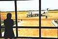
Airlines and destinations
Khoy Airport (IATA: KHY, ICAO: OITK) is an airport in Khoy, Iran.
| Airlines | Destinations |
|---|---|
| Iran Aseman Airlines | Tehran-Mehrabad |


Khoy Bus Terminals
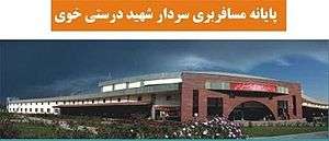
A bus terminus is a designated place where a bus or coach starts or ends its scheduled route. The terminus is the designated place that a timetable is timed from. Termini can be located at bus stations, interchanges, bus garages or simple bus stops. Termini can both start and stop at the same place, or may be in different locations for starting and finishing a route. Termini may or may not coincide with the use of bus stands.
Climate
Köppen-Geiger climate classification system classifies its climate as cold semi-arid (BSk).[17]
| Climate data for Khoy | |||||||||||||
|---|---|---|---|---|---|---|---|---|---|---|---|---|---|
| Month | Jan | Feb | Mar | Apr | May | Jun | Jul | Aug | Sep | Oct | Nov | Dec | Year |
| Average high °C (°F) | 2.8 (37) |
5.2 (41.4) |
11.6 (52.9) |
17.2 (63) |
23.9 (75) |
29.3 (84.7) |
32.6 (90.7) |
32.7 (90.9) |
28 (82) |
20.5 (68.9) |
13.1 (55.6) |
6.4 (43.5) |
18.61 (65.47) |
| Daily mean °C (°F) | −1.4 (29.5) |
0.6 (33.1) |
6.1 (43) |
11.2 (52.2) |
16.9 (62.4) |
21.4 (70.5) |
24.7 (76.5) |
24.5 (76.1) |
19.6 (67.3) |
13.6 (56.5) |
7.5 (45.5) |
1.9 (35.4) |
12.22 (54) |
| Average low °C (°F) | −5.6 (21.9) |
−4 (25) |
0.6 (33.1) |
5.3 (41.5) |
9.9 (49.8) |
13.5 (56.3) |
16.9 (62.4) |
16.3 (61.3) |
11.3 (52.3) |
6.7 (44.1) |
2 (36) |
−2.6 (27.3) |
5.86 (42.58) |
| Average precipitation mm (inches) | 28 (1.1) |
20 (0.79) |
31 (1.22) |
47 (1.85) |
54 (2.13) |
21 (0.83) |
7 (0.28) |
5 (0.2) |
8 (0.31) |
22 (0.87) |
22 (0.87) |
19 (0.75) |
284 (11.2) |
| Source: Climate-Data.org, altitude: 1136m[17] | |||||||||||||
Sights
Khoy is well known for the tomb of Shams Tabrizi, renowned Iranian poet and mystic.
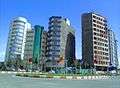 Khoy towers
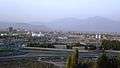 Khoy views
 Khoy city
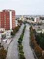
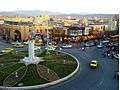 city center sqr
 khoy bazaar
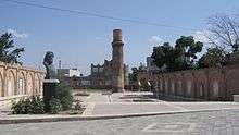
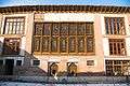 historical Kabiri House in Khoi
 Khoy church
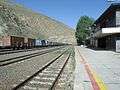 Khoy train station
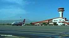 Khoy Airport
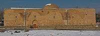
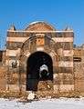 Stone gate of Khoy
 Kabiri House
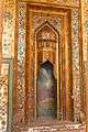 Kabiri House
 Kabiri House
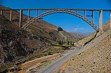
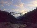 bridge of Khoy
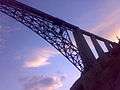 bridge of Khoy
- Mahlezan church
 Serkis
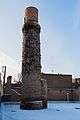 Tomb of Shams Tabrizi
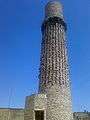 Tomb of Shams Tabrizi
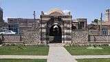 Stone gate of Khoy
Famous places
| Wikimedia Commons has media related to Xoy. |
- Tomb of Shams Tabrizi, Shams Tabrizi Tower
- Bastam and Bolourabad Castles
- Khatoon Bridge
- Old Stone Gate
- Old Bazaar
- Motallebkhan Mosque
- Mount Avrin
- Ghotour Iron Bridge[18]
- St. Sourp Serkis Church
- Pourya-ye Vali
Famous natives
For a complete list see: Category:People from Khoy
.jpg) Mullah Nasreddin, satirical Sufi.
Mullah Nasreddin, satirical Sufi.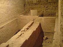 Jahan Shah, was the leader of the Kara Koyunlu oghuz Turks tribal federation in Azerbaijan and Arran.
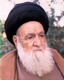 Abu al-Qasim al-Khoei, was one of the most influential Twelver Shia Islamic scholars.
 Jaleh Amouzgar , is a world-class Iranist and a university professor.
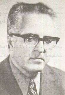 Abbas Zaryab, was a historian, translator, literature Professor and Iranologist.
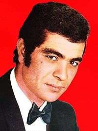 Behrouz Vossoughi, is an Iranian actor.
Twin towns
See also
References
- ↑ "Xoy, Iran Page". Retrieved 7 July 2008.
- ↑ Population according to statistical center of Iran in Persian
- ↑ Khoy can be found at GEOnet Names Server, at this link, by opening the Advanced Search box, entering "-3071618" in the "Unique Feature Id" form, and clicking on "Search Database".
- 1 2 "Country Study Guide-Azerbaijanis". STRATEGIC INFORMATION AND DEVELOPMENTS-USA. Retrieved 13 August 2013.
- 1 2 "Iran-Azerbaijanis". Library of Congress Country Studies. December 1987. Retrieved 13 August 2013.
- ↑ "All things and news about Xoy," All things and news about Xoy .
- ↑ ""Khvoy". Archived from the original on 9 February 2013.," World Gazetteer.
- 1 2 Andrew Burke, "Iran" pp. 138. Lonely Planet. ISBN 1742203493
- 1 2 3 4 5 6 Lida Balilan Asl, Elham Jafari. "Khoy's Expansion from Early Islam to Late Qajar According to Historical Documents" published spring 2013. vol 3
- ↑ Minorsky, Vladimir (1953) Studies in Caucasian History I. New Light on the Shaddadids of Ganja II. The Shaddadids of Ani III. Prehistory of Saladin page 52, CUP Archive, 1 jan. 1953 ISBN 978-0521057356
- ↑ L. Baker, Patricia; Smith, Hilary; Oleynik, Maria (2014). Iran. London, United Kingdom: Bradt Travel Guides. p. 158. ISBN 1841624020.
- ↑ Salia, Kalistrat (1983). History of the Georgian nation. Madison, WI: University of Wisconsin. p. 181.
- ↑ Mikaberidze, Alexander (2011). Conflict and Conquest in the Islamic World: A Historical Encyclopedia, Volume 1. Santa Barbara, California, USA: ABC-CLIO. p. 196. ISBN 1598843362.
- ↑ Somel, Selcuk Aksin (2003). Historical Dictionary of the Ottoman Empire. Scarecrow Press. p. xlvi. ISBN 978-0810866065.
- 1 2 Smith noted that the city had between 4000 and 7000 Muslim families, while only about 100 Armenian families were left. Smith, Eli (1834). Missionary Researches in Armenia: Including a Journey through Asia Minor, and into Georgia and Persia. G. Wightmann. p. 315.
- 1 2 3 4 Atabaki 2006, p. 70.
- 1 2 "Climate: Khoy - Climate graph, Temperature graph, Climate table". Climate-Data.org. Retrieved 9 September 2013.
- ↑ "Ghotour Valley Bridge". American Bridge Company. Retrieved 2013-03-25.
- ↑ "Rumi Remembered in Birthplace of Shams". Retrieved 21 March 2015.
Sources
- Atabaki, Touraj (2006). Iran and the First World War: Battleground of the Great Powers. I.B.Tauris. ISBN 978-1860649646.
External links
- The first portal fun of recreational and cultural city of Khoy
- Official website of Khoyee people's assembly
- Khoy government
- Khoy Municipality
- Nima Language Center
- Khoy journal
| Capital | 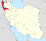 | |
|---|---|---|
| Counties and cities | ||
| Tourism | ||
| Places | ||