Kilclief
| Kilclief | |
| Irish: Cill Cleithe | |
 |
|
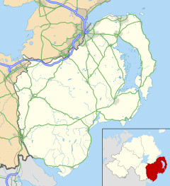
| County | County Down |
|---|---|
| Country | Northern Ireland |
| Sovereign state | United Kingdom |
| Police | Northern Ireland |
| Fire | Northern Ireland |
| Ambulance | Northern Ireland |
| EU Parliament | Northern Ireland |
| UK Parliament | South Down |
|
|
Coordinates: 54°20′09″N 5°32′41″W / 54.3357°N 5.5447°W
Kilclief is a civil parish in County Down, Northern Ireland. It is situated in the historic baronies of Lecale Lower and Lecale Upper. It is also a townland of 623 acres.[1]
Townlands
Kilclief civil parish contains the following townlands:[1]
- Acre McCricket
- Carrowdressex
- Cloghy
- Commonreagh
- Glebe
- Isle M'Cricket
- Kilclief
- Ringreagh
- Ross
- Rossglass
- Tullyfoyle Lower
- Tullyfoyle Upper
See also
References
- 1 2 "Kilclief". IreAtlas Townlands Database. Retrieved 20 May 2015.
This article is issued from Wikipedia - version of the 7/6/2016. The text is available under the Creative Commons Attribution/Share Alike but additional terms may apply for the media files.