Kings Langley railway station
| Kings Langley | |
|---|---|
 | |
| Location | |
| Place | Abbots Langley |
| Local authority | District of Three Rivers |
| Grid reference | TL080019 |
| Operations | |
| Station code | KGL |
| Managed by | London Midland |
| Number of platforms | 4 |
| DfT category | E |
|
Live arrivals/departures, station information and onward connections from National Rail Enquiries | |
| Annual rail passenger usage* | |
| 2010/11 |
|
| 2011/12 |
|
| 2012/13 |
|
| 2013/14 |
|
| 2014/15 |
|
| History | |
| Key dates | Opened 1839 |
| National Rail – UK railway stations | |
| * Annual estimated passenger usage based on sales of tickets in stated financial year(s) which end or originate at Kings Langley from Office of Rail and Road statistics. Methodology may vary year on year. | |
|
| |
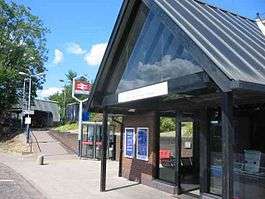
Kings Langley railway station is just under the M25 motorway at Junction 20. It serves the village of Kings Langley, and the nearby villages of Abbots Langley and Hunton Bridge. The station is 21 miles (34 km) north west of London Euston on the West Coast Main Line. The station and all services calling at the station are operated by London Midland.
The station was opened in 1839. From 1909 the station was known as Kings Langley & Abbots Langley, becoming Kings Langley on 6 May 1974.[1]
Services
Monday to Saturday a half-hourly service to London Euston southbound and Tring (Saturdays Milton Keynes Central) northbound. Evenings and Sundays there is an hourly in each. A number of night and rush hour services are extended to and from Birmingham New Street and Coventry. There is one train each weekday morning to and from Crewe.[2]
| Preceding station | |
Following station | ||
|---|---|---|---|---|
| Apsley | London Midland West Coast Main Line |
Watford Junction | ||
Accidents and Incidents
- On 5 January 1847, a Collision occurred between two Trains of the LNWR due to Fog. Two people died.
- On 1 October 1854, the late-running 17:40 Rugby to London Coal Train operated by LNWR arrived at King's Langley to drop off a Wagon for the Station. As the Train departed, a coupling failed, separating thirteen Wagons from the Train. Due to repairs on the Coupling, none of the Guards were guarding the Line for oncoming trains. Shortly thereafter, the 21:15 Goods train also from Rugby to London collided with the Coal Train's stranded portion just north of the Station. The Fireman of the Goods Train tried to jump off of his Train before the Collision, but his Leg was crushed and it was amputated.
- On 13 March 1935, an express meat train from Liverpool to London was brought to a halt at Kings Langley due to a defective vacuum brake. Due to a signalman's error a milk train ran into its rear. Wreckage spread across all four lines, with the result that a few minutes later the Camden to Holyhead freight collided with the debris, followed a few seconds later by the Toton to Willesden coal train.[3] Contemporaneous newsreel footage shows the aftermath of the four-fold accident.[4] All four lines were blocked for some time, William Buckley, the Milk Train's Driver was killed and the Guard of the Meat Train and Fireman of the Goods Train were injured. The Signalman of King's Langley Block had accepted the Meat Train from the previous Block at Nash Mills at 23:03, but didn't receive the Train and had a Phone call with the Nash Mills Signalman at 23:05 to ask about the Train, in which he believed that the Train Nash Mills wanted him to take was a Passenger Train that passed earlier, so he cleared his Signals for the Milk Train, not realizing that the Meat Train had entered his Section and broken down due to a Vacuum brake failure and was only just proceeding when the Milk Train collided.
- On 21 April 1963, the 12:20 Holyhead to Euston Express running on the Up Fast Line collided with a Rail-mounted Crane whose Boom was projected over the Up Fast Line north of the Station. The Express struck the Crane at a glancing blow, derailing the British Rail Class 40 hauling the Train and four Carriages. The Accident was caused by the failure of the Workman supervising the Crane work, as he had arranged to guard the Crane's work despite not being able to communicate with the Signalmen who would stop the Trains. A Restaurant Staff Member aboard the Express was slightly injured.
References
- ↑ Slater, J.N., ed. (July 1974). "Notes and News: Stations renamed by LMR". Railway Magazine. London: IPC Transport Press Ltd. 120 (879): 363. ISSN 0033-8923.
- ↑ GB eNRT December 2015 Edition, Tables 66 & 67 (Network Rail)
- ↑ "Report on the Accident At Kings Langley on 13th March 1935". Office of Rail Regulation.
- ↑ "Four Fold Train Collision". British Pathe.
External links
- Train times and station information for Kings Langley railway station from National Rail

Coordinates: 51°42′22″N 0°26′17″W / 51.706°N 0.438°W