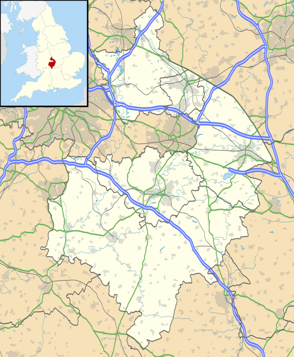
Rugby, Warwickshire
| Rugby | |
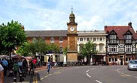 Rugby Market Place, looking west from Church Street |
|
 Rugby |
|
| Population | 70,628 (2011 Census) |
|---|---|
| Demonym | Rugbeian |
| OS grid reference | SP5075 |
| District | Rugby |
| Shire county | Warwickshire |
| Region | West Midlands |
| Country | England |
| Sovereign state | United Kingdom |
| Post town | RUGBY |
| Postcode district | CV21, CV22, CV23 |
| Dialling code | 01788 |
| Police | Warwickshire |
| Fire | Warwickshire |
| Ambulance | West Midlands |
| EU Parliament | West Midlands |
| UK Parliament | Rugby |
|
|
Coordinates: 52°22′N 1°16′W / 52.37°N 1.26°W
Rugby is a market town in Warwickshire, England, close to the River Avon. The town has a population of 70,628 (2011 census[1]) making it the second largest town in the county. The enclosing Borough of Rugby has a population of 100,500 (2011 census).
Rugby is 13 miles (21 km) east of Coventry, on the eastern edge of Warwickshire, near the borders with Northamptonshire and Leicestershire.
The town is credited with being the birthplace of rugby football.
History
Early Iron age settlement existed in the Rugby area, and a few miles outside what is now Rugby, existed a Roman settlement known as Tripontium. Rugby was originally a small Anglo-Saxon farming settlement, and was mentioned in the Domesday Book of 1086 as Rocheberie. Rugby obtained a charter to hold a market in 1255, and soon developed into a small country market town.[2]
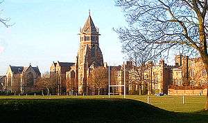
Rugby School was founded in 1567 with money left in the will of Lawrence Sheriff, a locally born grocer, who moved to London and earned his fortune. Rugby School was originally intended as a school for local boys, but over time became a mostly fee-paying private school. The Lawrence Sheriff School was eventually founded in the late 19th century to carry on Sheriff's original intentions.[2]
Rugby remained a sleepy country market town until the 19th century and the coming of the railways. In 1838 the London and Birmingham Railway was constructed past it, and in 1840 the Midland Counties Railway made a junction with the London and Birmingham at Rugby. Rugby became an important railway junction, and the proliferation of rail yards and workshops attracted workers. Rugby's population grew from just 2,500 in 1835, to over 10,000 by the 1880s.[3]
In the 1890s and 1900s heavy engineering industries began to set up in the town, and Rugby rapidly grew into a major industrial centre. Rugby expanded rapidly in the early decades of the 20th century as workers moved in. By the 1940s, the population of Rugby had grown to over 40,000.[4]
In the postwar years, Rugby became well served by the motorway network, with the M1 and M6 merging close to the town.
Fame
Rugby is most famous for the invention of rugby football, which is played throughout the world. The invention of the game is credited to William Webb Ellis whilst breaking the existing rules of a football match played in 1823 at Rugby School.
Rugby School is one of England's oldest and most prestigious public schools, and was the setting of Thomas Hughes's semi-autobiographical masterpiece Tom Brown's Schooldays. A substantial part of the 2004 dramatisation of the novel, starring Stephen Fry, was filmed on location at Rugby School. Hughes later set up a colony in America for the younger sons of the English gentry, who could not inherit under the laws of primogeniture, naming the town Rugby. The town of Rugby, Tennessee still exists.
Rugby is a birthplace of the jet engine. In April 1937 Frank Whittle built the world's first prototype jet engine at the British Thomson-Houston works in Rugby, and between 1936-41 based himself at Brownsover Hall on the outskirts, where he designed and developed early prototype engines.[5] Much of his work was carried out at nearby Lutterworth. Holography was invented in Rugby by the Hungarian inventor Dennis Gabor in 1947.[6]
In the 19th century, Rugby became famous for its once important railway junction which was the setting for Charles Dickens's story Mugby Junction.
Rugby today
The modern town of Rugby is an amalgamation of the original town with the former villages of Bilton, Hillmorton, Brownsover and Newbold-on-Avon which were incorporated into Rugby in 1932 when the town became a borough,[7] all except Brownsover still have their former village centres. Rugby also includes the areas of New Bilton, Overslade and Hillside. The spread of Rugby has nearly reached the villages of Clifton-upon-Dunsmore, Cawston, Dunchurch and Long Lawford.
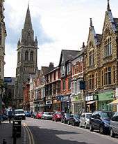
The town centre is mostly Victorian and early 20th century, however a few much older buildings survive, along with some more modern developments. Rugby was described by Nikolaus Pevsner as 'Butterfieldtown'[8] due to the number of buildings designed by William Butterfield in the 19th century, including much of Rugby School and the extension of St Andrews church.
Rugby town centre includes numerous restaurants of various kinds and many pubs. In 2002, Brownsover Fish Bar on Hollowell Way, Brownsover, was named as the best seller of Fish and Chips in the country.[9] The town centre is noted for its large number of pubs; in the 1960s it was recorded as having the second-highest number of pubs per square mile in England.[10] The main shopping area in Rugby is in the streets around the Clock Tower, two of which - High Street and Sheep Street - are pedestrianised. The town centre has an indoor shopping centre called The Clock Towers which opened in 1980. A street market is held in the town centre several days a week. In recent years several out-of-town retail centres have opened to the north of the town. Rugby contains several large parks, most notably Caldecott Park near the town hall. The borough council along with Warwickshire County Council had plans to pedestrianise North Street, a busy road through the town centre as part of the town centre's regeneration. This proved to be very controversial, with the town's major bus operator Stagecoach in Warwickshire threatening to reduce many bus services if the road closed to traffic. Ultimately however, the plans were abandoned in favour of a redesign of the nearby "Gyratory" traffic system which lies just outside the town centre itself.
In 2010 a short local bypass, the first part of the Rugby Western Relief Road, was opened, running from the A428 (Lawford Road) along the edge of the built-up area to the A4071 (road from Rugby through Bilton and Cawston) a little west of Cawston, to take through heavy traffic off suburban housing roads such as Addison Road. On 10 September 2010, the final part of Rugby's Western Relief Road was opened. The road runs from Potsford Dam near Cawston, through the Lawford Road and ending at Newbold Road, near the Avon Valley School. The initial estimated cost was projected at £36.6 million, while the final figure is in excess of £60 million.[11]
Politics and governance

Rugby is administered by two local authorities: Rugby Borough Council which covers Rugby and its surrounding countryside, and Warwickshire County Council. The two authorities are responsible for different aspects of local government. Rugby is an unparished area and so does not have its own town council.
From 1885 until 1983 Rugby was a constituency in itself. In 1983 Rugby became part of the parliamentary constituency of Rugby and Kenilworth, one of the Midlands' most marginal seats. Between 1983 and 1997 Jim Pawsey was the Conservative Member of Parliament, losing in 1997 to Labour's Andy King.
At the 2005 general election Jeremy Wright regained the seat for the Conservatives.
Following the recommendations of the Boundary Commission for England, Warwickshire was allocated a sixth parliamentary seat. In the 2010 general election, the existing Rugby and Kenilworth constituency was abolished and split in two. A new Rugby constituency was created, and a new constituency of Kenilworth and Southam formed to the south of Rugby, and as a result the town regained its pre-1983 status of returning its own member of parliament, albeit with the addition of the Bulkington Ward from Nuneaton. Jeremy Wright chose to stand for Kenilworth and Southam in the 2010 general election and was successful. Mark Pawsey, son of former Rugby MP Jim Pawsey, was elected for Rugby in 2010.
Geography
Nearby places
- Nearby cities: Birmingham, Coventry and Leicester.
- Nearby towns: Daventry, Hinckley, Kenilworth, Leamington Spa, Lutterworth, Northampton, Nuneaton, Warwick and Southam.
- Nearby villages: Barby, Bilton, Braunston, Brinklow, Dunchurch, Easenhall, Harborough Magna, Long Lawford, Monks Kirby, Newbold-on-Avon and Pailton.
Economy
Rugby's economy is mainly industrial. It is an engineering centre and has a long history of producing gas and steam turbines at the GEC and at the AEI. The AEI was earlier British Thomson-Houston or BTH. They used to dominate employment in the town. They are now amalgamated to form Alstom. Engineering in Rugby is still the most important sector.
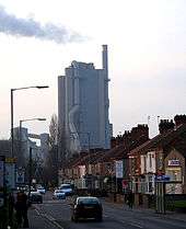
Another major industry in Rugby is cement making; Rugby Cement works, on the western outskirts, makes cement from the local Jurassic Lias limestone. The cement industry in Rugby dates back to the 1860s. In the 1990s the Rugby Cement works was dramatically expanded, and in 2000 other Rugby Cement plants at Southam and Rochester were closed, with all production moved to the Rugby plant,[12] now one of the largest of its type in Europe.
Since the 1980s several large industrial estates have been built to the north, and warehousing and distribution have become major employers.
Further afield, within the Rugby borough is the Rolls-Royce engineering works near Ansty. This is nearer to Coventry than Rugby, but is a major employer to the Rugby population.
Tourism is also important to the town's economy, especially related to Rugby football.[13]
One of the last links to Rugby's rural past was the cattle market held near the railway station, and earlier in the "Market Place" in the old centre of Rugby since medieval times. The market near the railway station was closed in late 2008 and the site has been redeveloped into housing, a hotel and a Tesco store as part of a wider scheme of work in the station area.
Landmarks
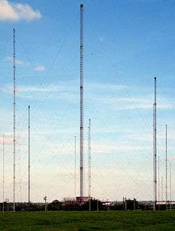
One of the most notable landmarks around Rugby was, until August 2007, the Rugby VLF transmitter, a large radio transmitting station just to the east of the town. The station was opened in 1926 and was used to transmit the MSF time signal. Several of the masts however were decommissioned and demolished by explosives in 2004, although a few, including four of the biggest masts remained until 2007. (Firing the explosive charges was delayed by rabbits gnawing the wires).[14] The remaining four 'tall' masts were demolished on the afternoon of 2 August 2007 with no prior publicity. However the majority of the smaller masts still stand, awaiting demolition before becoming a housing estate
Rugby Cement works, to the west of the town, can be seen for many miles. Standing at just 115 metres high, the landmark is not a popular one— in 2005 it came in the top ten of a poll of buildings people would like to see demolished on the Channel 4 television series Demolition.[15] In October 2006, the owners of the Rugby Cement works, Cemex, were fined £400,000 for excessive pollution after a court case brought by the Environment Agency.[16]

The town has statues of three famous locals: Rupert Brooke, Thomas Hughes and William Webb Ellis. The Rupert Brooke statue is situated at the forked junction of Regent Street on the green and commemorates his contribution to poetry. Thomas Hughes' statue stands in the gardens of the Temple Reading Rooms (the central library of Rugby school) on Barby Road. Since England won the Rugby World Cup in 2003, the William Webb Ellis statue outside Rugby School is one of the most visited parts of the town.
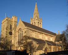
St Andrew's Church, in the town centre, is Rugby's original parish church. A church has stood on the site since the 13th century. The church was extensively re-built and expanded in the 19th century, designed by William Butterfield. The expanded church included a new east tower, which has a spire 182 feet (55 m) high. However some parts of the older medieval church were retained, most notably the 22 metre high west tower which bears strong resemblance to a castle turret. The west tower was probably built during the reign of Henry III (1216–1272) to serve a defensive as well as religious role, and is Rugby's oldest building. The church has other artefacts of medieval Rugby including the 13th-century parish chest, and a medieval font.[17]
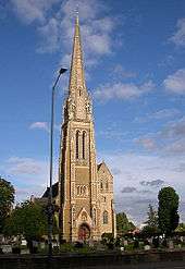
Rugby's main Roman Catholic church is St. Maries on Dunchurch Road. It is one of the town's most well-known landmarks as it is quite dominant on the skyline. Its spire is the tallest in Warwickshire . The church was built in 1872, designed by Pugin in the Early English style.[17]
Places of interest
Places of interest in the town include:
- The Rugby School Museum, which has audio-visual displays about the history of Rugby School and of the town.
- The combined art gallery and museum. The art gallery contains a nationally recognised collection of contemporary art. The museum contains, amongst other things, Roman artefacts dug up from the nearby Roman settlement of Tripontium.
- The Rugby Football Museum, where traditional rugby balls are handmade. It contains much rugby football memorabilia.
- The Benn Hall, a conference, seminar, exhibition and party venue.
Places of interest around Rugby include:
- Brandon Marsh
- Dunchurch - Historic village
- Draycote Water - Reservoir and nature reserve
- Oxford Canal
- Stanford Hall
- Ryton Organic Gardens[18]
Suburbs
- Bilton
- Binley Woods
- Brownsover
- Cawston
- Church Lawford
- Dunchurch
- Hillmorton
- Hillside
- Kingsway
- Long Lawford
- New Bilton
- Newbold-on-Avon
- Overslade
- Wolston
Transport
Road
Rugby is near several major trunk routes including the M6, M1 and M45 motorways and the A45 road. Other less important main roads include the A426 road, the A428 road and the Rugby Western Relief Road, linking the A45 with the Leicester Road, that connects with the Motorway at Junction 1 of the M6.
Bus
Buses run to Coventry, Southam, Leamington Spa, Daventry, Leicester and Northampton as well as serving the major estates of the town on a regular basis.
Railways
Rugby railway station is served by the West Coast Main Line, and has frequent regular services to London Euston , Birmingham New Street, Stafford and Crewe. There are also some albeit very infrequent services between Rugby and Glasgow Central, the North West of England, Shrewsbury Chester, and Holyhead. Rugby Rail Users Group is campaigning hard to secure more direct express services down the Trent Valley main line to Crewe, Preston and beyond.
Rugby has had a railway station since 1838, when the London and Birmingham Railway was opened, though the present station dates from 1885. Rugby station used to be served by lines which have now been closed, including lines to Leicester. Leamington Spa, and Peterborough. These were closed in the 1960s under the Beeching axe
Between 1899 and 1969, Rugby had a second station; Rugby Central station on the former Great Central Main Line which had services to London Marylebone to the south and Leicester, Nottingham and Shefffield to the north. The station and line were closed under the Beeching Axe.
The British Railways steam locomotive testing centre was in Rugby.
Warwickshire County Council proposed a new station to serve Rugby called Rugby Parkway station, which will be on the Northampton Loop Line, south-east of the existing station, serving the Hillmorton area of the town. The station is to be built in between the current edge of town and DIRFT to accommodate for the future expansion of the town where 2600 homes are planned to be built over a 15 to 20-year period. Construction work on the new station is due to begin in May 2018 and it is planned to open in 2019.[19]
Air
There are direct rail links to the nearest major airport Birmingham Airport. The smaller Coventry Airport is nearby.
Canal
The Oxford Canal runs along the north edge of Rugby, but south of the new housing estates round Brownsover.
Education
- Present day schools and colleges
Schools in Rugby include the Lawrence Sheriff School for boys (which came top of the country in the 2009 and 2010 GCSE League Tables),[20] and Rugby High School for Girls, which are grammar schools. Ashlawn School (formerly Dunsmore School for Boys, Dunsmore School for Girls and Fareham School) is a partially selective school.
Rugby School is a public school. This is home of rugby football and is co-educational. There are several other schools, equivalent to the type of school formerly known as a secondary modern school. These are Bilton School (formerly Herbert Kay & Westlands School, and Bilton High School), Avon Valley School (formerly 'Newbold School'), and Harris Church of England Academy. Other schools in the town include Eastlands Primary School, Abbots Farm Junior School, Paddox Primary School and St. Oswalds C.E. Primary School.
- Former schools and colleges
- Bishop Wulstan School
- William Temple College (1954–71): an Anglican theological college
Sport
- Rugby has a number of rugby union teams including; the Rugby Lions, Rugby Welsh, Rugby St. Andrews RFC, Newbold, AEI (Rugby) Rugby Football Club and Old Laurentian RFC.
- Rugby has a non-league football club Rugby Town F.C., which used to be known as VS Rugby.
Notable residents
- Chris Adams (1955–2001), wrestler
- Neil Adams (born 1958), judoka
- Matthew Arnold (1822–1888), poet
- Thomas Arnold (1795–1842), educator
- Melanie Astles, French aerobatic champion (born in Rugby)
- David Barby (1943–2012), antiques expert
- Ian Bell (born 1982), cricketer
- Laura Bettinson (born 1988), singer-songwriter
- Arthur Bostrom (born 1955), actor
- Rupert Brooke (1887–1915), poet
- Emily Burns (born 1994), singer-songwriter
- Lewis Carroll (1832–1898), writer
- Neville Chamberlain (1869–1940), politician
- Ben "Yahtzee" Croshaw (born 1983), comedic writer
- Dennis Gabor (1900–1979), inventor
- Thomas Hedley (c. 1800–1890), entrepreneur
- Peter Kember (born 1965), musician
- Norman Lockyer (1836–1920), scientist
- Rose Macaulay (1881–1958), writer
- John Marquez (born 1970), actor and cinematographer
- Katharine Merry (born 1974), sprinter
- James Morrison (born 1984), singer-songwriter
- Jason Pierce (born 1965), singer and musician
- Tim Pigott-Smith (born 1946), actor
- Peter Purves (born 1939), television presenter
- Peter Rogers (born 1947), businessman
- Sam Ruddock (born 1990), track and field athlete
- Salman Rushdie (born 1947), novelist
- Franco Wanyama (born 1968), boxer
- Kevin Warwick (born 1954), engineer
- Frank Whittle (1907–1996), inventor
- Clem Wilson (1875–1944), cricketer
Twin towns
Rugby is twinned with:
 Évreux, France[21]
 Rüsselsheim, Germany
See also
References
- ↑ "Rugby (Warwickshire)". Rugby on City Population. Retrieved 8 April 2014.
- 1 2 "Rugby history timeline". Rugby Local History Research Group. Retrieved 30 August 2016.
- ↑ Rugby local history group
- ↑ Rugby local history group
- ↑ "The Papers of Sir Frank Whittle" (HTTP). Janus. Retrieved 15 September 2007.
- ↑ Nobel Prize Winner Denis Garbor, inventor of holography
- ↑ visionofbritain.org
- ↑ Allen, Geoff, (2000) Warwickshire Towns & Villages, ISBN 1-85058-642-X
- ↑ Fish & Chip Shop of the Year Competition
- ↑ http://www.drugby.co.uk/wotsthedeal/crappytown.html
- ↑ "Final £60.5 million bill for Rugby Western Relief Road". Rugby Advertiser. 15 December 2010. Retrieved 12 January 2011.
- ↑ minerals.com (PDF)
- ↑ Rugby BC Action on Tourism
- ↑ "Rabbits delay masts' demolition". BBC News. 20 June 2004. Retrieved 15 September 2007.
- ↑ "The dirty dozen" (HTTP). Channel 4. Retrieved 15 September 2007.
- ↑ "EA Court Case details". Environment Agency. Archived from the original on 27 September 2007. Retrieved 15 September 2007.
- 1 2 Rugby, Aspects of the Past. Rugby Local History Group
- ↑ http://www.hdra.org.uk/gardens/ryton.htm
- ↑ "Second train station to be built as Rugby expands". Rugby Advertiser. 15 October 2015. Retrieved 23 November 2015.
- ↑ The Daily Telegraph league table
- ↑ "British towns twinned with French towns [via WaybackMachine.com]". Archant Community Media Ltd. Archived from the original on 5 July 2013. Retrieved 20 July 2013.
Further reading
- Rugby, Aspects of the Past. Rugby Local History Group.
- Timmins, E.W. (1990). Rugby: A Pictorial History. ISBN 0-85033-700-3.
- Elliot, Peter H (1985). Rugby's Railway Heritage. ISBN 0-907917-06-2.
- Rawlins, Eddy; Osborne, Andy (1988). Rugby Growth Of A Town. ISBN 0-907917-06-2.
External links
| Boroughs or districts | |
|---|---|
| Major settlements | |
| Rivers | |
| Canals | |
| Topics | |