Kinkasan
| Native name: <span class="nickname" ">Japanese: 金華山 | |
|---|---|
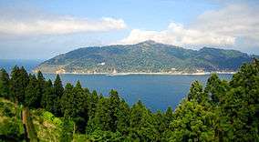 View from Oshika Peninsula | |
| Geography | |
| Location | Pacific Ocean |
| Coordinates | 38°17′43″N 141°34′00″E / 38.29528°N 141.56667°E |
| Archipelago | Oshika |
| Area | 10.28 km2 (3.97 sq mi) |
| Coastline | 25 km (15.5 mi) |
| Highest elevation | 445 m (1,460 ft) |
| Highest point | Kinkasan |
| Administration | |
|
Japan | |
| Demographics | |
| Population | 6 (2004) |
| Ethnic groups | Japanese |
Kinkasan (金華山 Kinkasan, or Kinkazan), is a small island in Miyagi Prefecture in north-eastern Japan. It is considered one of the Three Holiest Places of the Tōhoku region, along with Dewa Sanzan and Osorezan. It lies in the Pacific Ocean approximately one kilometer off the Oshika Peninsula.[1]
According to legend, those who pay a visit to the shrine in the island three years in a row will have no financial difficulties for the rest of their lives.
Geography
Kinkasan is 9.5 km2 (3.7 sq mi) in area, and its highest point is the pyramid-shaped Mount Kinka, which stands at 445 m (1,460 ft).[1]
It can be reached by ferry from Ishinomaki.[2]
History
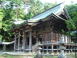
There is a shrine on the island, called Koganeyama-jinja, which dates from the 8th century.[3]
During the early Meiji period, Kinkasan Lighthouse designed by Richard Henry Brunton was completed in 1876.
Kinkasan was hit by the 2011 Tōhoku earthquake and tsunami, the island being one of the closest pieces of land to the epicenter at approximately 68 km (42 mi) away; only one or two minor islands are slightly closer.
References
- 1 2 "Mt. Kinka (Kinkasan Island)". Matsushima. Japan-i. Archived from the original on May 4, 2010. Retrieved 15 March 2011.
- ↑ Chris Rowthorn. "Northern Honshu". Japan. Lonely Planet. p. 530. Retrieved 13 February 2014.
- ↑ "Kinkasan". Japan: the official guide. Japan National Tourism Organization. Retrieved 13 December 2012.
External links
![]() Media related to Kinkasan at Wikimedia Commons
Media related to Kinkasan at Wikimedia Commons
| Wikivoyage has a travel guide for Kinkasan. |
Coordinates: 38°17′N 141°34′E / 38.283°N 141.567°E