Knarrevik
Not to be confused with Knarvik.
| Knarrevik Knarrvika | |
|---|---|
| Village | |
|
View of the village | |
 Knarrevik  Knarrevik Location in Hordaland county | |
| Coordinates: 60°22′14″N 05°09′11″E / 60.37056°N 5.15306°ECoordinates: 60°22′14″N 05°09′11″E / 60.37056°N 5.15306°E | |
| Country | Norway |
| Region | Western Norway |
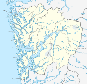
| County | Hordaland |
| District | Midhordland |
| Municipality | Fjell |
| Elevation[1] | 42 m (138 ft) |
| Time zone | CET (UTC+01:00) |
| • Summer (DST) | CEST (UTC+02:00) |
| Post Code | 5355 Knarrevik |
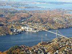
Knarrevik or Knarrvika is a village in Fjell municipality in Hordaland county, Norway. It is located along the Byfjorden on the eastern coast of the island of Litlesotra, just north of the municipal centre of Straume. The western end of the Sotra Bridge lies at Knarrevik.
The 6.62-square-kilometre (1,640-acre) urban area of Knarrevik/Straume has a population (2013) of 10,302; giving the area a population density of 1,556 inhabitants per square kilometre (4,030/sq mi).[2]
References
- ↑ "Knarrvika, Fjell (Hordaland)" (in Norwegian). yr.no. Retrieved 2014-12-08.
- ↑ Statistisk sentralbyrå (1 January 2013). "Urban settlements. Population and area, by municipality.".
This article is issued from Wikipedia - version of the 8/4/2016. The text is available under the Creative Commons Attribution/Share Alike but additional terms may apply for the media files.