Kožlí (Písek District)
| Kožlí | |
|---|---|
| Municipality | |
 Kožlí | |
| Coordinates: 49°30′57″N 14°8′48″E / 49.51583°N 14.14667°ECoordinates: 49°30′57″N 14°8′48″E / 49.51583°N 14.14667°E | |
| Country |
|
| Region | South Bohemian |
| District | Písek |
| Area | |
| • Total | 4.33 km2 (1.67 sq mi) |
| Elevation | 398 m (1,306 ft) |
| Population (2005) | |
| • Total | 50 |
| • Density | 12/km2 (30/sq mi) |
| Postal code | 39804 |
| Website | http://www.severnipisecko.cz/kozli.htm |
Kožlí (German: Koschli) is a village and municipality (obec) in Písek District in the South Bohemian Region of the Czech Republic.
Geography
Kožlí lies near the western shore of the Orlík Reservoir along the Vltava River, approximately 24 kilometres (15 mi) north of Písek, 65 km (40 mi) north of České Budějovice, and 67 km (42 mi) south of Prague.
The municipality covers an area of 4.33 square kilometres (1.67 sq mi), and has a population of 50 (as at 2005).
History
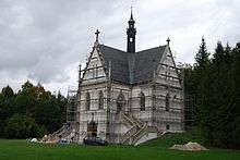
The village in the Kingdom of Bohemia was first mentioned in a 1396 deed. In the east, it borders on the extensive gardens of Orlík Castle, ceded to the noble House of Eggenberg after the 1620 Battle of White Mountain. It was inherited by the House of Schwarzenberg in 1717. From 1875 to 1877 the Orlík cadet branch had the Neo-Gothic Schwarzenbergská hrobka erected near Kožlí, a funerary chapel housing the mortal remains of Field Marshal Prince Karl Philipp of Schwarzenberg (1771–1820).
References
| Wikimedia Commons has media related to Kožlí (Písek District). |