Koh Kong Province
| Koh Kong ខេត្តកោះកុង | |
|---|---|
| Province | |
|
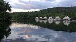
Floating hotel at Tatai River | |
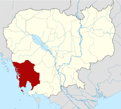 Map of Cambodia highlighting Koh Kong | |
| Coordinates: 11°23′57″N 103°29′41″E / 11.39917°N 103.49472°ECoordinates: 11°23′57″N 103°29′41″E / 11.39917°N 103.49472°E | |
| Country |
|
| Provincial status | 1959 |
| Capital | Khemarak Phoumin |
| Government | |
| • Governor | Bun Leut (CPP) |
| Area | |
| • Total | 11,160 km2 (4,310 sq mi) |
| Area rank | Ranked 6th |
| Population (2008)[1] | |
| • Total | 139,722 |
| • Rank | Ranked 21st |
| • Density | 13/km2 (32/sq mi) |
| • Density rank | Ranked 22nd |
| Time zone | UTC+07 |
| Dialing code | +855 |
| ISO 3166 code | KH-9 |
| Districts | 8 |
| Communes | 33 |
| Villages | 133 |
Koh Kong (Khmer: ខេត្តកោះកុង; IPA: [kɑh koŋ] "Kong Island") is a province (khaet) of Cambodia. The name means "Kŏng Island Province". Its capital is Khemarak Phoumin. The province was called Patchanta Khirikhet (Thai: ปัจจันตคิรีเขตร; Thai pronunciation: [pàt.tɕan.tàʔ kʰi.riː.kʰèːt]) from 1795 to 1904.
Geography
The most southwestern province of Cambodia, Koh Kong has a long undeveloped coastline and a mountainous, forested and largely inaccessible interior which embraces part of the Cardamom Mountains, Cambodia's largest national park (Botum Sakor National Park) and a section of Kirirom National Park. Its tourist attractions include casinos and waterfalls, while an export processing zone and new port facilities are being developed for trade.
History
From 1795 to 1904 the area was under Siamese administration with the local name of "Koh Kong." During the reign of King Mongkut, the name Prachankirikhet was given to the city since the area falls in the same latitude as another city of Prachuap Khiri Khan which also had its name changed during the same year. In 1904, the region and the city of Trat was ceded to French Indochina in exchange of French troop evacuation from Chanthaburi. Yet, in 1907 Trat was returned back to Siam in exchange of the Siamese province of Inner Cambodia while Koh Kong remained part of French Cambodia.
After Cambodia’s liberation from the Khmer Rouge in 1979, Koh Kong province was quite under-populated. After the national government encouraged people to live in Koh Kong, there has been a net influx of people. It is estimated that the average annual growth rate in Koh Kong is 16%, which has put pressure on the mangrove resources in the province. Koh Kong's towns have developed rapidly partially in response to market pressures from Thailand and because of immigration from other parts of Cambodia.[2]
Districts
The province is subdivided into six districts (srŏk) and one city (Krong).
| ISO Code | District | Romanization |
|---|---|---|
| 0901 | បូទុមសាគរ | Botum Sakor |
| 0902 | គីរីសាគរ | Kiri Sakor |
| 0903 | កោះកុង | Kaoh Kong |
| 0904 | ស្មាច់មានជ័យ ប្ដូរជា ក្រុងខេមរភូមិន្ទ | Smach Meanchey has changed to Khemarak Phoumin |
| 0905 | មណ្ឌលសីម៉ា | Mondol Seima |
| 0906 | ស្រែអំបិល | Srae Ambel |
| 0907 | ថ្មបាំង | Thmar Bang |
Border crossing
The province is an increasingly popular gateway to Cambodia from Hat Lek in eastern Thailand, in part due to the reasonably direct access to the port and beach resort town of Sihanoukville. The border is at Cham Yeam, about 14 km from Koh Kong.
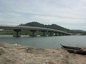
Traveling to Koh Kong has become an enjoyable journey, where bridges were built, the first stage in 2002. A landmark of Koh Kong was made possible by L.Y.P. Group — the second longest bridge built in Cambodia (Neak Loeung Bridge took the number one spot in 2015). The 1,900-meter crossing can be seen connecting provincial town of Koh Kong to Koh Kong Resort and the international check point. In 2007 a new sealed road (National Route 48) was completed from the town to Sre Ambel on the Phnom Penh to Sihanoukville highway, including the four remaining river crossings with bridges were opened in May 2008 which are donations by the Thai government to Cambodia.
References
- ↑ "General Population Census of Cambodia 2008 - Provisional population totals" (PDF). National Institute of Statistics, Ministry of Planning. 3 September 2008.
- ↑ Peam Krasop Wildlife Sanctuary: Insights into Life in the Mangroves, International Symposium on Protection and Management of Coastal Marine Ecosystem.
External links
- The Koh Kong Website
- Koh Kong Provincial Resources
- Kirirom National Park, Cambodia
- Koh Kong Websites
- Very comprehensive adventure site in Tatai
 |
Pursat Province | Gulf of Thailand Prachuap Khiri Khan Province |
| |
| Trat Province, |
|
Kampong Speu Province | ||
| ||||
| | ||||
| Gulf of Thailand | Sihanoukville Province | Kampot Province |
| Capital city | | |
|---|---|---|
| Districts | ||
| Places | ||
| Provinces | ||
|---|---|---|
| Municipalities | ||