Prachuap Khiri Khan
| Prachuap Khiri Khan ประจวบคีรีขันธ์ | |
|---|---|
| Town | |
|
Aerial Photograph | |
 Prachuap Khiri Khan | |
| Coordinates: 11°49′N 99°48′E / 11.817°N 99.800°E | |
| Country | Thailand |
| Provinces | Prachuap Khiri Khan Province |
| Amphoe | Mueang Prachuap Khiri Khan District |
| Elevation | 9 m (30 ft) |
| Population (2000) | 26,926 |
| Time zone | UTC+7 (UTC+7) |
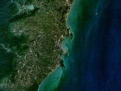
Prachuap Khiri Khan (Thai: ประจวบคีรีขันธ์, pronounced [prā.t͡ɕùa̯p.kʰīː.rīː.kʰǎn]) is a town in southern Thailand. It is the capital of Prachuap Khiri Khan Province and is on the coast at one of the narrowest stretches in Thailand, only 10 kilometres (6.2 mi) from the Burmese border at Dan Sing Khon in the Tenasserim Hills. The area has large pineapple and coconut industries, in addition to being popular with Thai tourists. The town is 291 km south of Bangkok by road.
History
Prachuap Khiri Khan is home to a Royal Thai Air Force base, and was an invasion point for Japanese troops on 8 December 1941, during World War II. A commemoration is held each December to honour the 38 Thai airmen and civilians who died in the fighting against the Japanese 143rd Infantry Regiment in the Battle of Prachuap Khiri Khan.
Climate
Prachuap Khiri Khan has a tropical savanna climate (Köppen climate classification Aw). Seasons are not as distinct as in more northerly parts of Thailand; temperatures are quite similar throughout the year and the dry and wet seasons are not as clearly defined, with appreciable rain falling in all months. However, in general the months from December to April are drier with about 45 millimetres (1.8 in) in each month, while October and November are the wettest months with over 200 millimetres (7.9 in) each. The other months, from May to September, have an intermediate level of rainfall around 100 millimetres (3.9 in).
| Climate data for Prachuap Khiri Khan (1981–2010) | |||||||||||||
|---|---|---|---|---|---|---|---|---|---|---|---|---|---|
| Month | Jan | Feb | Mar | Apr | May | Jun | Jul | Aug | Sep | Oct | Nov | Dec | Year |
| Record high °C (°F) | 35.5 (95.9) |
37.8 (100) |
38.8 (101.8) |
40.0 (104) |
39.5 (103.1) |
38.7 (101.7) |
38.0 (100.4) |
37.3 (99.1) |
37.3 (99.1) |
37.0 (98.6) |
36.2 (97.2) |
36.0 (96.8) |
40.0 (104) |
| Average high °C (°F) | 30.8 (87.4) |
31.6 (88.9) |
32.5 (90.5) |
34.0 (93.2) |
33.5 (92.3) |
32.8 (91) |
32.5 (90.5) |
32.1 (89.8) |
32.3 (90.1) |
31.3 (88.3) |
30.9 (87.6) |
30.4 (86.7) |
32.1 (89.8) |
| Daily mean °C (°F) | 25.4 (77.7) |
26.6 (79.9) |
27.9 (82.2) |
29.2 (84.6) |
28.9 (84) |
28.4 (83.1) |
28.0 (82.4) |
27.8 (82) |
27.7 (81.9) |
27.1 (80.8) |
26.6 (79.9) |
25.5 (77.9) |
27.4 (81.3) |
| Average low °C (°F) | 20.6 (69.1) |
21.7 (71.1) |
23.4 (74.1) |
25.0 (77) |
25.3 (77.5) |
25.3 (77.5) |
24.9 (76.8) |
25.0 (77) |
24.6 (76.3) |
23.8 (74.8) |
23.0 (73.4) |
21.2 (70.2) |
23.7 (74.7) |
| Record low °C (°F) | 13.3 (55.9) |
15.2 (59.4) |
16.9 (62.4) |
21.6 (70.9) |
22.4 (72.3) |
20.9 (69.6) |
21.6 (70.9) |
22.0 (71.6) |
20.7 (69.3) |
17.9 (64.2) |
16.7 (62.1) |
12.8 (55) |
12.8 (55) |
| Average rainfall mm (inches) | 24.4 (0.961) |
21.8 (0.858) |
71.8 (2.827) |
55.5 (2.185) |
126.9 (4.996) |
86.2 (3.394) |
109.3 (4.303) |
99.1 (3.902) |
99.5 (3.917) |
227.8 (8.969) |
154.5 (6.083) |
15.0 (0.591) |
1,091.8 (42.984) |
| Average rainy days | 2.8 | 4.9 | 4.7 | 5.2 | 13.5 | 15.9 | 16.5 | 17.7 | 15.6 | 16.9 | 7.5 | 2.0 | 121.2 |
| Average relative humidity (%) | 75 | 77 | 77 | 76 | 77 | 76 | 77 | 77 | 78 | 82 | 75 | 70 | 76 |
| Mean monthly sunshine hours | 229.4 | 214.7 | 201.5 | 201.0 | 155.0 | 114.0 | 117.8 | 114.7 | 108.0 | 145.7 | 171.0 | 229.4 | 2,002.2 |
| Mean daily sunshine hours | 7.4 | 7.6 | 6.5 | 6.7 | 5.0 | 3.8 | 3.8 | 3.7 | 3.6 | 4.7 | 5.7 | 7.4 | 5.5 |
| Source #1: Thai Meteorological Department[1] | |||||||||||||
| Source #2: Office of Water Management and Hydrology, Royal Irrigation Department (sun and humidity)[2] | |||||||||||||
Transportation
Prachuap Khiri Khan can reached from Bangkok by train on the Southern Line from Hualamphong Railway Station.
The main road, which runs past the city from north to south, is Route 4 (Phetkasem Road). To the north, this road connects to Phetchaburi, Ratchaburi and Bangkok; to the south, it connects to Chumphon, Ranong, Phang Nga, Krabi, Trang, Phatthalung and the border with Malaysia near Sadao.
Prachuap Khiri Khan is served by Prachuap Airport, at the south end of town.[3]
Industry
Australian company ASC and Thai company Silkline International formed a joint venture to build three Keka-class patrol boats for the Royal Thai Navy at Silkline's yard at Pak Nam Pran in Prachuap Khiri Khan.[4]
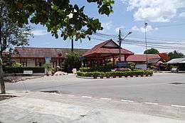
Gallery
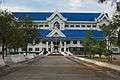 City Hall
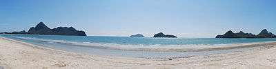 Ao Manao Bay
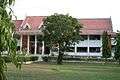 Old City Hall
 Pillar Shrine
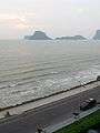 Prachuap Bay at dawn
References
- ↑ "Climatological Data for the Period 1981–2010". Thai Meteorological Department. p. 22. Retrieved 6 August 2016.
- ↑ "ปริมาณการใช้น้ำของพืชอ้างอิงโดยวิธีของ Penman Monteith (Reference Crop Evapotranspiration by Penman Monteith)" (PDF) (in Thai). Office of Water Management and Hydrology, Royal Irrigation Department. p. 84. Retrieved 6 August 2016.
- ↑ "Prachuap Airport". OurAirports. Retrieved 6 February 2013.
- ↑ "Australian ship builder to build landing craft for Royal Thai Navy". Pattaya Mail. Retrieved 2011-04-02.
External links
 Prachuap Khiri Khan travel guide from Wikivoyage
Coordinates: 11°49′N 99°48′E / 11.817°N 99.800°E
| ||