Kosino-Ukhtomsky District
| Kosino-Ukhtomsky District Косино-Ухтомский (Russian) | |
|---|---|
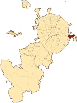 Location of Kosino-Ukhtomsky District on the map of Moscow | |
.png) |
 |
|
| |
| Location | |
| Country | Russia |
| Federal subject | Moscow |
| Statistics | |
| Time zone | MSK (UTC+03:00)[1] |
| Kosino-Ukhtomsky District on WikiCommons | |
Kosino-Ukhtomsky District is an administrative district (raion) of Eastern Administrative Okrug, and one of the 125 raions of Moscow, Russia.[2]
Moscow Districts in Eastern Administrative Okrug city Moscow and the same name Municipalities Moscow intra-city municipal unions. It borders on the Veshnyaki, Vykhino-Zhulebino, Novokosino and Nekrasovka, as well as city Lyubertsy. The area of the district is 1506 hectares.
District Kosino Ukhtomsky consists of three districts—Kozhukhovo, Kosino Kosino and Ukhtomsky. Population: 16,917.
History
According to archaeological evidence, people lived in this area for a very long time. On the territory of Kosino and its surroundings at the end of the last century were discovered 4 groups mounds (of 15 mounds) and 2 Neolithic sites. People are so-called Abashevskaya archaeological culture Bronze Age lived here more in the 2nd millennium BCE. Three groups of mounds located between the White and Holy lakes, excavated, and one group—near Zhulebino—is still waiting for the excavation. Kosinski found in barrows items now in the Museum of Anthropology at Moscow State University.
See also
References
Notes
- ↑ Правительство Российской Федерации. Федеральный закон №107-ФЗ от 3 июня 2011 г. «Об исчислении времени», в ред. Федерального закона №271-ФЗ от 03 июля 2016 г. «О внесении изменений в Федеральный закон "Об исчислении времени"». Вступил в силу по истечении шестидесяти дней после дня официального опубликования (6 августа 2011 г.). Опубликован: "Российская газета", №120, 6 июня 2011 г. (Government of the Russian Federation. Federal Law #107-FZ of June 31, 2011 On Calculating Time, as amended by the Federal Law #271-FZ of July 03, 2016 On Amending Federal Law "On Calculating Time". Effective as of after sixty days following the day of the official publication.).
- ↑ Государственный комитет Российской Федерации по статистике. Комитет Российской Федерации по стандартизации, метрологии и сертификации. №ОК 019-95 1 января 1997 г. «Общероссийский классификатор объектов административно-территориального деления. Код 45», в ред. изменения №259/2014 от 12 декабря 2014 г.. (State Statistics Committee of the Russian Federation. Committee of the Russian Federation on Standardization, Metrology, and Certification. #OK 019-95 January 1, 1997 Russian Classification of Objects of Administrative Division . Code 45, as amended by the Amendment #259/2014 of December 12, 2014. ).
Sources
| Central Administrative Okrug | 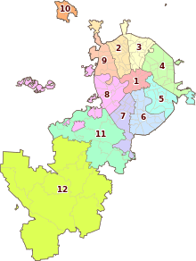 . . | |
|---|---|---|
| Northern Administrative Okrug | ||
| North-Eastern Administrative Okrug | ||
| Eastern Administrative Okrug | ||
| South-Eastern Administrative Okrug | ||
| Southern Administrative Okrug | ||
| South-Western Administrative Okrug | ||
| Western Administrative Okrug | ||
| North-Western Administrative Okrug | ||
| Zelenogradsky Administrative Okrug | ||
| Novomoskovsky Administrative Okrug |
| |
| Troitsky Administrative Okrug |
| |
Coordinates: 55°42′53″N 37°53′34″E / 55.71472°N 37.89278°E