Kourou
| Kourou | ||
|---|---|---|
|
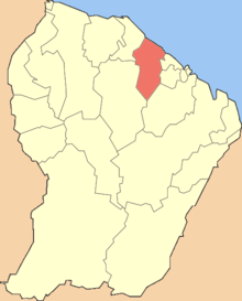
A view of the allée du Bac, in Kourou | ||
| ||
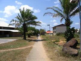
 Location of the commune (in red) in French Guiana | ||
| Coordinates: 5°09′35″N 52°39′01″W / 5.1597°N 52.6503°WCoordinates: 5°09′35″N 52°39′01″W / 5.1597°N 52.6503°W | ||
| Country | France | |
| Overseas region and department | French Guiana | |
| Arrondissement | Cayenne | |
| Government | ||
| • Mayor (2014-2020) | François Ringuet | |
| Area1 | 2,160 km2 (830 sq mi) | |
| Population (Jan. 2011[1])2 | 25,260 | |
| • Density | 12/km2 (30/sq mi) | |
| INSEE/Postal code | 97304 / 97310 | |
|
1 French Land Register data, which excludes lakes, ponds, glaciers > 1 km² (0.386 sq mi or 247 acres) and river estuaries. 2 Population without double counting: residents of multiple communes (e.g., students and military personnel) only counted once. | ||

Kourou is a commune in French Guiana, an overseas region and department of France located in South America. In addition to being an administrative district in French Guiana, it is also the main town in that district.
Within the Kourou district lies the Guiana Space Centre, France and the European Space Agency's main spaceport.
Geography

Some 60 km (37 mi) northwest of the French Guyanese capital Cayenne the Kourou River empties into the Atlantic Ocean. At the mouth of this river sits the town of Kourou, which is ringed by four hills: Carapa, Pariacabo, Café and Lombard, with the Singes and Condamine mountains not far behind. There are three lakes within the town's city limits: Lake Bois Diable (where one can take lessons in jetski and other aquatic sports), Lake Marie-Claire (the smallest and calmest), and Lake Bois Chaudat (the biggest of the three; also open to sport lovers, especially canoers and kayakers). Long white sand beaches and some rocky outcrops line the town's ocean coast, the riverbank and all points inland consisting mostly of mangrove and dense tropical rainforest.
The town had a fast-growing population of 25,918 inhabitants at the 2007 census. Its inhabitants can be classified into three ethnic groups of roughly equal size:
- Indigenous peoples (mostly Kalina - also called Galibi), Creoles, Maroons (Boni and Saramaka),
- Whites (mostly French, from Metropolitan France), and
- Foreigners (Brazilians, Surinamese, Hmong, Haitians, Guyanese, etc.)
The Saramaka mostly settled in the quartier Saramaka, along the river. Much of it burned down in a fire in 2006, and hasn't yet fully recovered.
Guiana in general has a high level of crime compared to the rest of France's départements; Kourou has an average of two armed robberies a day. A march protesting the high level of insecurity felt by most of the population was held in Kourou on 27 October 2006.[2] Shopkeepers of Chinese descent in particular are often targeted by armed robbers, their cash registers emptied and some products stolen.
Kourou is the port of departure for those going to the îles du Salut, of which the most famous is Devil's Island. It is also common for many to go up the river in canoes on weekends to camp in the forest.
The Guiana Space Centre, where the European Space Agency starts missions, is located a little behind and outside the town. Part of the town and the islands are closed during rocket launches.
Climate
| Climate data for Kourou, French Guiana (1981–2010 averages) | |||||||||||||
|---|---|---|---|---|---|---|---|---|---|---|---|---|---|
| Month | Jan | Feb | Mar | Apr | May | Jun | Jul | Aug | Sep | Oct | Nov | Dec | Year |
| Record high °C (°F) | 31.3 (88.3) |
31.7 (89.1) |
31.6 (88.9) |
31.8 (89.2) |
32.4 (90.3) |
31.9 (89.4) |
33.0 (91.4) |
33.7 (92.7) |
34.0 (93.2) |
34.5 (94.1) |
33.5 (92.3) |
32.7 (90.9) |
34.5 (94.1) |
| Average high °C (°F) | 29.0 (84.2) |
29.1 (84.4) |
29.4 (84.9) |
29.6 (85.3) |
29.6 (85.3) |
29.7 (85.5) |
30.4 (86.7) |
31.0 (87.8) |
31.7 (89.1) |
31.9 (89.4) |
31.2 (88.2) |
29.8 (85.6) |
30.2 (86.4) |
| Average low °C (°F) | 23.8 (74.8) |
24.0 (75.2) |
24.2 (75.6) |
24.3 (75.7) |
23.9 (75) |
23.2 (73.8) |
22.7 (72.9) |
22.8 (73) |
22.6 (72.7) |
22.8 (73) |
23.1 (73.6) |
23.7 (74.7) |
23.4 (74.1) |
| Record low °C (°F) | 19.2 (66.6) |
20.0 (68) |
19.5 (67.1) |
19.0 (66.2) |
20.0 (68) |
20.0 (68) |
20.0 (68) |
19.1 (66.4) |
19.1 (66.4) |
19.0 (66.2) |
18.1 (64.6) |
18.8 (65.8) |
18.1 (64.6) |
| Average precipitation mm (inches) | 358.4 (14.11) |
220.3 (8.673) |
265.9 (10.469) |
391.0 (15.394) |
503.2 (19.811) |
377.1 (14.846) |
148.6 (5.85) |
87.7 (3.453) |
32.8 (1.291) |
49.1 (1.933) |
123.8 (4.874) |
280.5 (11.043) |
2,838.4 (111.748) |
| Average precipitation days | 20.67 | 17.07 | 17.03 | 20.27 | 24.87 | 23.83 | 15.93 | 8.53 | 4.43 | 6.40 | 11.80 | 20.13 | 190.96 |
| Mean monthly sunshine hours | 119.9 | 116.1 | 149.2 | 138.6 | 142.9 | 172.3 | 219.6 | 248.5 | 259.9 | 250.6 | 204.8 | 141.4 | 2,163.7 |
| Source: Meteo France[3][4] | |||||||||||||
History
Before the Europeans
Not much is known of the pre-colonial era. The area was mostly populated by Kalina, or Galibi before the arrival of the French in the late 17th century.
There is a place not far from the town called les Roches Gravées ("The Carved Rocks"), where indigenous art can be seen on the rock walls.
Early colonization
Vicente Yáñez Pinzón sailed along most of the north coast of South America and passed by the current location of Kourou in 1500.
The Jesuits Lombard and Creuilly baptised a few Galibis at the church of Saint Nicholas in Cayenne in December 1710 and returned with them soon after to farm the land at Guatémala, across the river from Kourou. The Society of Jesus was disbanded (in Guiana) in 1762, however, and Kourou was nothing more than a small village until the arrival of the Expedition.
In 1744, La Condamine, in charge of the expedition sent to Peru in 1735 to determine the length of a degree of the meridian arc in the neighbourhood of the equator, passed by and gave his name to one of the mountains behind Kourou.
Expedition
The mission at Kourou being abandoned by the Jesuits, the engineers Mentelle and Tugny designed the layout of the future town. This resulted in the neighbourhood called the Bourg, around the Church of Saint Catherine and next to the port on the river.
That same year, 1763, as agreed in the Treaty of Paris, Great Britain took control of New France. Having lost their largest and richest colony, the French decided to send a large expedition to Guiana, commanded by Choiseul. Around 10,000 to 12,000 people, mostly Frenchmen, tempted by stories of an El Dorado on the other side of the ocean, settled in Kourou.
The small town, surrounded by marshes and rainforest, was unprepared for such a massive influx of people, and around 6,000 of the pioneers died within the year due to fevers and other illnesses. Those remaining fled to the îles du Salut, free of mosquitoes due to constant winds, to recover before being repatriated to Metropolitan France. Hence the name, "Salvation Islands." Previously they had been known as the îles du Diable ("Devil's Islands"), and one of the islands retains the name to this day.
The failure of the Expedition only served to discourage settling in Guiana. The colony earned the nickname Enfer Vert ("Green Hell"), which it is still trying to shake. No other project of mass colonisation was undertaken, and the population of Whites was always drastically lower than that of the slaves. The population of the colony, of all races, did not rise above 20,000 until the gold rush (starting in 1855), the second abolition of slavery in 1848 and the founding of the prisons.
Prisons
Kourou was formerly the home of the "Kourou Prison" which was one of the main prisons in French Guiana, and which was also a part of the notorious Devil's Island Prison System. The Kourou Prison was dedicated mostly to agriculture.
In 1852 the three main islands off of Kourou's coast, the Salut island group (which included Devil's Island) also became prisons. These island prisons held mostly political prisoners as well as some of France's toughest criminals. The first prisoners arrived in 1862.
In 1938, a law was passed prohibiting the transport of any new prisoners from France to French Guyana. In 1946 eight years later, the Kourou Prison was finally shut down, while some prisoners were kept in other Guyanese prisons until as late as 1953.
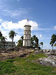
After the closing of the prison, most of the prison buildings were demolished to make room for the Hôtel des Roches, but some vestiges of that period remain. One notable remnant of the prison is the Dreyfus Tower, which stands where the river meets the ocean. This tower was used in pre-radio days to communicate with the islands via Semaphore. Other prison ruins which remain are the prison bakery (which is now on private property - but can still be seen from a cul-de-sac), and an old prison fountain near the moucaya palm trees.
CSG and the French Foreign Legion Arrive
In 1965, the Centre Spatial Guyanais (Guiana Space Centre) was founded a little behind the town by the CNES. With the launch facility being used by the European Space Agency (ESA) since 1975, the urbanisation of Kourou began in earnest. The population of the town grew rapidly, and has not shown any signs of slowing since.
The 3rd Foreign Infantry Regiment of the French Foreign Legion, whose mission is to protect the CSG, has had a base in the Forget neighbourhood since 1973. They clashed with the Creoles in 1985 and 2006.[5]
Demographics
| 1954 | 1961 | 1967 | 1974 | 1982 | 1990 | 1999 | 2006 | 2011 | ||||
|---|---|---|---|---|---|---|---|---|---|---|---|---|
| 563 | 659 | 3,117 | 4,720 | 7,061 | 13,873 | 19,107 | 23,813 | 25,260 | ||||
| Official figures from past censuses.[1][6] | ||||||||||||
Average population growth of Kourou:
- 1954-1961: +13 people per year (+2.2% per year)
- 1961-1967: +408 people per year (+29.5% per year)
- 1967-1974: +229 people per year (+6.1% per year)
- 1974-1982: +317 people per year (+5.6% per year)
- 1982-1990: +850 people per year (+8.8% per year)
- 1990-1999: +583 people per year (+3.6% per year)
- 1999-2006: +690 people per year (+3.3% per year)
- 2006-2011: +289 people per year (+1.2% per year)
Economy
Kourou's economy is largely dominated by the CSG, from which the European Ariane rockets are launched, as well as the Russian Soyuz and the Italian Vega rockets.
Politics
Kourou is the main town on an "administrative district" of French Guyana. Such as district is equivalent to a county in the United States.
Tourism
- The Centre Spatial Guyanais (CSG) gets many visitors all year round.
- The Musée de l'Espace is a museum devoted to space and space exploration.
- The Îles du Salut: Of the three islands, only two, Île Royale and Île Saint-Joseph, can be visited. The third is Devil's Island.
- Les Roches gravées: Indigenous rock art, not far from the small industrial zone called Pariacabo.
- There are several marked public footpaths in the jungle, of which the most well-known and used is the one on the Montagne des Singes.
- Kourou River: Many people go up the river on canoes or small boats to camp along the shore in open dwellings, or simply in hammocks.
- The ocean may not be clear (it is brown due to the Amazonian silt), but both it and the beaches are clean.
See also
References
- 1 2 INSEE. "Historique des populations par commune depuis 1961". Retrieved 2014-02-01.
- ↑ (French) http://www.blada.com/jodlas/1561-Kourou_:_une_ville_sans_oreilles.htm Article on Blada.com about the march (with photos).
- ↑ "Données climatiques de la station de Kourou" (in French). Meteo France. Retrieved January 5, 2016.
- ↑ "Climat Guyane". Meteo France. Retrieved January 5, 2016.
- ↑ Le Monde, 10.08.06 (in French)
- ↑ Gérard Brasseur (1978). La Guyane française : un bilan de trente années (in French). La Documentation française. p. 33. Retrieved 2013-10-15.
External links
| Wikimedia Commons has media related to Kourou. |
| Wikivoyage has a travel guide for Kourou. |
- Town Hall
- Centre Spatial Guyanais (CSG)
- Musée de l'Espace
- Blada, all-purpose message board and newspaper for Guiana in general and Kourou in particular (in French).