Kuřimany
| Kuřimany | |
|---|---|
| Municipality | |
 Kuřimany | |
| Coordinates: 49°11′50″N 13°58′1″E / 49.19722°N 13.96694°ECoordinates: 49°11′50″N 13°58′1″E / 49.19722°N 13.96694°E | |
| Country |
|
| Region | South Bohemian |
| District | Strakonice |
| Area | |
| • Total | 3.1 km2 (1.2 sq mi) |
| Elevation | 476 m (1,562 ft) |
| Population (2006) | |
| • Total | 25 |
| • Density | 8.1/km2 (21/sq mi) |
| Postal code | 386 01 |
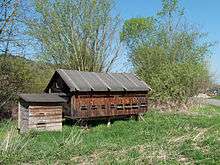
Beehive in Kuřimany
Kuřimany is a village and municipality (obec) in Strakonice District in the South Bohemian Region of the Czech Republic.
The municipality covers an area of 3.1 square kilometres (1.2 sq mi), and has a population of 25 (as at 3 July 2006).
Kuřimany lies approximately 9 kilometres (6 mi) south-east of Strakonice, 45 km (28 mi) north-west of České Budějovice, and 105 km (65 mi) south of Prague.
Places of interest
- Saint John of Nepomuk Chapel in Kuřimany
- Chapel between Kuřimany and Milejovice
References
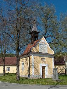
Saint John of Nepomuk Chapel in Kuřimany
| Wikimedia Commons has media related to Kuřimany. |
This article is issued from Wikipedia - version of the 4/7/2016. The text is available under the Creative Commons Attribution/Share Alike but additional terms may apply for the media files.