Kualoa Airfield
Kualoa Airfield.svg.png) | |
|---|---|
| Part of Seventh Air Force | |
| Oahu, near Kaaawa, Hawaii, USA | |
|
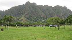
The southern end of the runway is now a park | |
| Coordinates | 21°31′35″N 157°50′22″W / 21.52639°N 157.83944°W |
| Type | Military airfield |
| Site information | |
| Controlled by | United States Army Air Forces |
Kualoa Airfield is a former wartime airfield on Oahu, Hawaii. Part of it is now the Kualoa Regional Park.
History
Kualoa Airfield was constructed in 1942 and used during World War II on 1000 acres of Kualoa Ranch land. It was a satellite field for units assigned to Bellows Field and was used mainly for training.
The aircraft ramp was made of perforated high strength steel (Marston mats) that was used extensively by the military during World War II for quickly establishing airfields. Kualoa Field consisted of a single north/south runway. It was depicted as having a single 6,500' hard-surface runway. The road to Kaʻaʻawa and the north shore crossed over Kualoa's runway, so the cars would have to wait whenever an airplane took off.
The 28th Photographic Reconnaissance Squadron, operating P-38, F-4 and A-24 aircraft was stationed at Kualoa between October 9, 1944 and May 8, 1945.
The 18th Fighter Group, operating P-40’s, also was stationed there briefly.
No evidence suggests that Kualoa was ever paved. The entire runway was formed of pierced steel planking. The steel planking makes a strong case that the military had no plans to keep Kualoa open any longer than it was needed. Following the war the land was returned to the original owners.
Today

The airfield stretched across Kamehameha Highway from Kualoa Ranch to what is now Kualoa Regional Park. What's left of Kualoa's former runway is now a dirt road stretching from north of the Kualoa Ranch visitor center, and through to the maintenance yard. The entrance to Kualoa Regional park off of Kamehameha Highway was once part of the airstrip. The property inland became Ahupuaʻa O Kahana State Park and Kualoa Ranch. The only remaining aviation activity at the site is occasional use by model airplane flyers that use the grass field. A few of the fortified revetments along the sheer cliffs above the former airfield still remain intact, including Battery Cooper, as the only remaining indication of this site's military history.
Kualoa point land is the northern end of Kāneʻohe Bay. The small island Mokoliʻi, often called "Chinaman's Hat", is right offshore. The road is called Kamehameha Highway, state route 83. The park includes two small campgrounds administered by the City and County of Honolulu.[1]
See also
- Hawaii World War II Army Airfields
References
![]() This article incorporates public domain material from the Air Force Historical Research Agency website http://www.afhra.af.mil/.
This article incorporates public domain material from the Air Force Historical Research Agency website http://www.afhra.af.mil/.
- Maurer, Maurer, ed. (1982) [1969]. Combat Squadrons of the Air Force, World War II (PDF) (reprint ed.). Washington, DC: Office of Air Force History. ISBN 0-405-12194-6. LCCN 70605402. OCLC 72556.
- ↑ "Camping Information". Honolulu County Parks and Recreation web site. Retrieved 2010-04-14.
External links
- "Kualoa Regional Park: Information and Beach Analysis". Hawaii Beach Safety web site. University of Hawaii. Retrieved 2010-04-14.
- Kualoa Regional Park - official site
Previously: Hawaiian Air Force (1940-1942) | |||||||||||||||||||||||||||||||||||
| Airfields |
| | |||||||||||||||||||||||||||||||||
| Units |
| ||||||||||||||||||||||||||||||||||