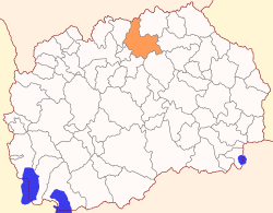
Kumanovo Municipality
| Municipality of Kumanovo Општина Куманово | |||
|---|---|---|---|
| Urban municipality | |||
| |||
 | |||
| Country |
| ||
| Region | Northeastern Statistical Region | ||
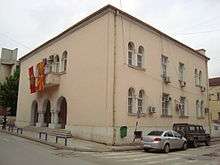
| Municipal seat | Kumanovo | ||
| Government | |||
| • Mayor | Zoran Damjanovski (SDSM) | ||
| Area | |||
| • Total | 509.48 km2 (196.71 sq mi) | ||
| Population | |||
| • Total | 105,484 | ||
| • Density | 207.04/km2 (536.2/sq mi) | ||
| Time zone | CET (UTC+1) | ||
| Area code(s) | 031 | ||
| car plates | KU | ||
| Website | http://www.Kumanovo.gov.mk | ||
Kumanovo (Macedonian: Куманово [kuˈmanɔvɔ]) is a municipality located in the northern part of Republic of Macedonia. Kumanovo is also the name of the city where the municipal seat is found. Kumanovo Municipality is part of the Northeastern Statistical Region.
Geography
The municipality has an area of 509,48 km² and borders Lipkovo Municipality, Ilinden Municipality and Aračinovo Municipality to the west, Serbia to the north, Sveti Nikole Municipality and Petrovec Municipality to the south, and Staro Nagoričane Municipality and Kratovo Municipality to the east.
History
By the 2003 territorial division of the republic, Orašac Municipality was merged with Kumanovo as was part of the rural Klečevce Municipality. The other part of Klečevce was attached to Staro Nagoričane Municipality.
Demographics
Without Orašac Municipality, Kumanovo had 94,589 inhabitants in 1994 and 103,205 at the last national census.[1] The population of the former Orašac Municipality was 1,638 in 1994 and 1,252 in 2002. The present-day combined municipality has 105,484 inhabitants, which makes it the most populous municipality in Macedonia.
According to the 2002 census, ethnic groups in the Kumanovo Municipality include:
- Macedonians = 63,746 (60.4%)
- Albanians = 27,290 (25.8%)
- Serbs = 9,062 (8.6%)
- Roma = 4,256 (4.1%)
- Turks = 292 (0.28%)
- Vlachs = 147 (0.10%)
- others = 691 (0.62%)
Inhabited places
There are 48 inhabited places in this municipality, one town and 49 villages.
| Inhabited Places | Total | Macedonians | Albanians | Turks | Roma | Vlachs | Serbs | Bosnians | Others |
| Kumanovo Municipality | 105484 | 63746 | 27290 | 292 | 4256 | 147 | 9062 | 20 | 671 |
| Agino Selo | 965 | 949 | - | - | - | - | 13 | - | 3 |
| Bedinje | 2327 | 1451 | 547 | - | 156 | - | 164 | - | 9 |
| Biljanovce | 1231 | 1195 | - | - | - | - | 32 | - | 4 |
| Brzak | 104 | 88 | - | - | - | - | 16 | - | - |
| Vakv | 108 | 108 | - | - | - | - | - | - | - |
| Vince | 90 | 90 | - | - | - | - | - | - | - |
| Gorno Konjare | 1136 | 555 | 255 | - | - | - | 324 | - | 2 |
| D'lga | - | - | - | - | - | - | - | - | - |
| Dobrošane | 1655 | 1571 | - | - | 24 | 39 | 17 | - | 4 |
| Dolno Konjare | 1286 | 669 | 91 | - | 2 | 0 | 516 | - | 8 |
| Karabičane | 43 | 5 | - | - | - | - | 38 | - | - |
| Karpoš | 5403 | 4917 | - | - | 14 | - | 450 | - | 22 |
| Kumanovo | 70872 | 42840 | 18277 | 256 | 4042 | 108 | 4769 | 20 | 560 |
| Lopate | 2448 | 478 | 1886 | - | - | - | 80 | - | 4 |
| Ljubodrag | 686 | 440 | - | - | - | - | 243 | - | 3 |
| Novo Selo | 274 | 70 | - | - | - | - | 243 | - | - |
| Proevce | 2311 | 2218 | - | - | 18 | - | 73 | - | 2 |
| Pčinja | 793 | 789 | - | - | - | - | 4 | - | - |
| Režanovce | 705 | 661 | 1 | 1 | - | - | 42 | - | - |
| Rečica | 557 | 110 | - | - | - | - | 445 | - | 2 |
| Romanovce | 2794 | 716 | 2028 | 35 | - | - | 6 | - | 9 |
| Šopot | 318 | - | 308 | - | - | - | 6 | - | 4 |
| Studena Bara | 344 | 343 | - | - | - | - | 1 | - | - |
| Šušica | 34 | 3 | 1 | - | - | - | 30 | - | - |
| Tabanovce | 910 | 205 | 177 | - | - | - | 516 | - | 12 |
| Tromega | 1298 | 692 | - | - | - | - | 604 | - | 12 |
| Umni Dol | 442 | 216 | - | - | - | - | 226 | - | - |
| Cerkezi | 3741 | 2 | 3719 | - | - | - | - | - | 2 |
| Četirce | 294 | 34 | - | - | - | - | 215 | - | - |
| Šupli Kamen | 81 | 80 | - | - | - | - | 1 | - | - |
| Jačince | 106 | 106 | - | - | - | - | - | - | - |
| Skačkovci | 160 | 159 | - | - | - | - | 1 | - | - |
| Pezovo | 53 | 53 | - | - | - | - | - | - | - |
| Orašac | 387 | 387 | - | - | - | - | - | - | - |
| Novoseljane | 46 | 46 | - | - | - | - | - | - | - |
| Murgaš | 63 | 62 | - | - | - | - | 1 | - | - |
| K’sanje | 48 | 48 | - | - | - | - | - | - | - |
| Kučkarevo | 105 | 105 | - | - | - | - | - | - | - |
| Kutlibeg | 13 | 13 | - | - | - | - | - | - | - |
| Kosmatac | 41 | 41 | - | - | - | - | - | - | - |
| Količko | 86 | 83 | - | - | - | - | 3 | - | - |
| Kokošinje | 45 | 44 | - | - | - | - | 1 | - | - |
| Klečevce | 573 | 555 | - | - | - | - | 18 | - | - |
| Žubovce | 57 | 57 | - | - | - | - | - | - | - |
| Živinje | 46 | 46 | - | - | - | - | - | - | - |
| Dovezence | 123 | 123 | - | - | - | - | - | - | - |
| Gradište | 192 | 189 | - | - | - | - | 3 | - | - |
| Gabreš | 71 | 70 | - | - | - | - | 1 | - | - |
| Beljakovce | 64 | 64 | - | - | - | - | - | - | - |
See also
References
- ↑ 2002 census results in English and Macedonian (PDF)
External links
| Wikimedia Commons has media related to Kumanovo Municipality. |
Coordinates: 42°05′22″N 21°46′22″E / 42.0894°N 21.7728°E