Kunhar River
| Kunhar | |
| River | |
 | |
| Country | Pakistan |
|---|---|
| province | Khyber Pakhtunkhwa |
| District | Mansehra District |
| Source | Lulusar lake |
| - elevation | 3,950 m (12,959 ft) |
| Mouth | Jhelum River |
| - location | Muzaffarabad |
| Length | 166 km (103 mi) |
The Kunhar River (Urdu: دریائے کنہار, also known as Nain-Sukh "eye's repose") is 166 kilometres (103 mi) long river, located primarily in the Khyber Pakhtunkhwa province, northern Pakistan. It is in the Indus River watershed basin.
Origin & Route
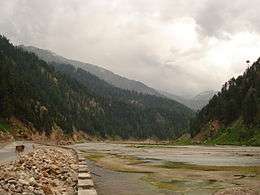
The river originates from Lulusar Lake, nearly 48 kilometres (30 mi) upstream from Naran Valley. Waters of Dudipat and Saiful Muluk Lakes feed the river besides glacial waters from Malka Parbat and other high peaks in the valley. The Kunhar river flows through the entire Kaghan valley, Jalkhad, the Naran valley, Kaghan, Balakot, Garhi Habibullah and Dalola. The River joins with Jhelum River at confluence just outside Muzaffarabad, in the Azad Jammu and Kashmir province, Pakistan.

Hydropower Development
Kunhar river has great hydropower generation potential and currently SK Hydro project is under construction in Kaghan Valley, Mansehra which has an installed capacity of 840 MW.
Fresh water trout and trout farming
The Kunhar river is considered to have good quality trout. Trout is also produced in farms that have been developed along the river. The farms take fresh water from Kunhar River and pass it back to the river in order to provide fresh water for the trout.
See also
External links
Gallery
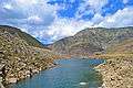 Lulusar Lake - the source of River Kunhar
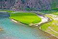 Peaceful Kunhar near Jalkhad KPK
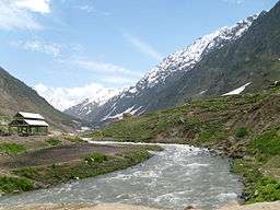
 Kunhar near Paras
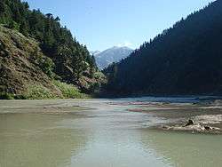
| Wikimedia Commons has media related to Kunhar River. |
Coordinates: 34°17′N 73°29′E / 34.283°N 73.483°E