Taliparamba West
| Taliparamba West | |
|---|---|
| suburb | |
|
The historic Kuppam Bridge | |
| Coordinates: 12°02′59″N 75°20′51″E / 12.049687°N 75.347414°ECoordinates: 12°02′59″N 75°20′51″E / 12.049687°N 75.347414°E | |
| Country |
|
| State | Kerala |
| District | Kannur |
| Languages | |
| • Official | Malayalam, English |
| Time zone | IST (UTC+5:30) |
| ISO 3166 code | IN-KL |
| Vehicle registration | KL-59 |
| Nearest city | Taliparamba |
| Lok Sabha constituency | Kasargode |

Taliparamba West is a group of suburbs and villages on the north and west of Taliparamba Town. The locality is divided into two parts, south and north; South Kuppam is a part of Taliparamba municipality while North Kuppam, Near mukkunnu, is a part of Pariyaram Village Panchayath.
During the 1960s and 1970s this village was a commercial center of spices. The National Highway-17 is passing through Kuppam.
Suburbs and Villages
- Narikode, Muthukuda and Ezhome
- Pattuvam, Cherukunnu and Pazhayangadi
- Kadannappally, Kuttiyeri, Pariyaram and Pilathara
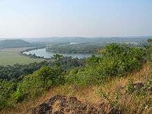
Kuppam River
Kuppam got its name from the Kuppam River, one of the 44 Rivers of Kerala, which originates from the hilly area of western Karnataka and flows into the Arabian Sea.
Once, waterways in the Kuppam River was the only mode of travel into the hilly areas of Kannur district. But after the construction of Kuppam Bridge, passenger boats almost disappeared. Kuppam Bridge was built in 1958 with British construction methods, which consists of 5 huge arches each side. The bridge is attractive for its construction style.New Bridge at Kuttiyeri kadavu ,connecting kuttiyeri and Pariyaram Villages was opened in 2015.
See also
- Kuppam River
- Taliparamba
- Narikode
- Iringal
- Vellavu
- Vayad
- Thiruvettoor
- Chapparapadavu
Image gallery
 Cheriyoor
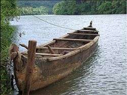 Cheriyoor jetty
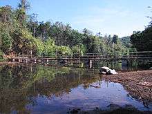 Kuppam river
Location
 |
Pariyaram | Iringal | Pacheni | |
| Ezhome | |
Vellavu | ||
| ||||
| | ||||
| Pattuvam | Pulimparamba | Taliparamba Town |
See also
- Taliparamba
- Pattuvam
- Ezhom
- Pariyaram
- Pilathara
- Pazhayangadi
| Wikimedia Commons has media related to Taliparamba. |