Kyrenia Mountains
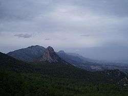
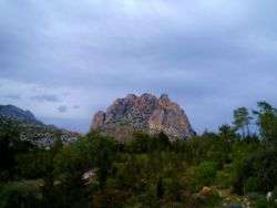
The Kyrenia Mountains is a long, narrow mountain range that runs for approximately 160 km (100 mi) along the northern coast of the island of Cyprus. It is primarily made of limestone, with some marble. Its highest peak is Mount Kyparissovouno, at 1,024 m (3,360 ft).[1] Pentadaktylos (also spelt Pentadactylos; Greek: Πενταδάκτυλος; Turkish: Beşparmak is another name for the Kyrenia Mountains,[2] though Britannica refers to Pentadaktylos as the "western portion" of the latter,[3] or the part west of Melounta.[1] Pentadaktylos (lit. "five-fingered") is so-named after one of its most distinguishing features, a peak that resembles five fingers.[2]
A devastating fire in July 1995 burned large portions of the Kyrenia Mountains, resulting in the loss of significant forest land and natural habitat.
The only other mountain range in Cyprus is the Troodos Mountains.
Geology
These mountains are a series of sedimentary formations from the Permian to the Middle Miocene pushed up by a collision of the African and Eurasian plates. Though only half the height of the Troodos Mountains, the Kyrenia Mountains are rugged and rise abruptly from the Mesaoria plain.[4]
History
The location of the mountains near the sea made them desirable locations for watch towers and castles overlooking the northern Cyprus coast, as well as the central plain. These castles generally date from the 10th through the 15th centuries, primarily constructed by the Byzantines and Lusignans. The castles of St. Hilarion, Buffavento, and Kantara sit astride peaks and were of strategic importance during much of the history of Cyprus during the Middle Ages.
Painted flag
.JPG)
A flag of Northern Cyprus is painted on the southern slope of the Kyrenia Mountains. It is reportedly 425 metres wide and 250 metres high, and is illuminated at night.[5]
Legends
There are many legends about the Pentadactylos mountains. One tells the story of a conceited villager who fell in love with the local queen and asked for her hand in marriage. The queen wished to be rid of the impertinent young man and requested that he bring her some water from the spring of Apostolos Andreas monastery in the Karpas, a perilous journey in those days. The man set off and after several weeks returned with a skin full of that precious water. The queen was most dismayed to see that he had succeeded, but still refused to marry him. In a fit of rage, he poured the water on to the earth, seized a handful of the resulting mud and threw it at the queens head. She ducked and the lump of mud sailed far across the plain to land on top of the Kyrenia mountain range, where it is to this day, still showing the impression of the thwarted villager’s five fingers.
Another famous one is of the Byzantine hero Digenis Akritas. Tradition has it that Digenis Akritas's hand gripped the mountain to get out of the sea when he came to free Cyprus from its Saracen invaders, and this is his handprint. (He also threw a large rock across Cyprus to get at the Saracen ships. That rock landed in Paphos at the site of the birthplace of Aphrodite, thus known to this day as Petra Tou Romiou or "Rock of the Greek".
References
| Wikimedia Commons has media related to Kyrenia mountain range. |
- 1 2 "Kyrenia Mountains". Encyclopædia Britannica. Retrieved 22 November 2014.
- 1 2 Spilling, Michael (1999). Cyprus. Marshall Cavendish. p. 9.
- ↑ Tesch, Noah, ed. (2013). The Britannica Guide to Countries of the European Union: Cyprus, Greece, and Malta. Britannica Educational Publishing. p. 2.
- ↑ Panayides, Ioannis (2009). "Cyprus". In Gillespie, Rosemary G.; Clague, D. A. Encyclopedia of Islands. University of California Press. p. 212.
- ↑ "Written question - Turkish flag on Mount Pentadaktylos - E-5074/2009". European Parliament. 24 November 2009. Retrieved 22 November 2014.
Coordinates: 35°16′59″N 33°32′02″E / 35.283°N 33.534°E