Kyyvesi
| Kyyvesi | |
|---|---|
 | |
| Location | Mikkeli |
| Coordinates | 61°58′N 27°07′E / 61.967°N 27.117°ECoordinates: 61°58′N 27°07′E / 61.967°N 27.117°E |
| Type | Lake |
| Catchment area | Kymijoki |
| Basin countries | Finland |
| Surface area | 129.947 km2 (50.173 sq mi) |
| Average depth | 4.39 m (14.4 ft) |
| Max. depth | 35.25 m (115.6 ft) |
| Water volume | 0.57 km3 (460,000 acre·ft) |
| Shore length1 | 857.26 km (532.68 mi) |
| Surface elevation | 100.65 m (330.2 ft) |
| Frozen | December–April |
| Islands | Emäsalo, Honkasalo, Porosaari, Riuttasaari |
| References | [1] |
| 1 Shore length is not a well-defined measure. | |
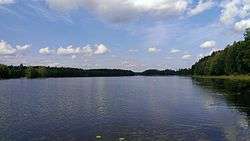
Kyyvesi (transl.Viper Water) is a rather large lake in the Southern Savonia region of Finland. Spite its size (129,95 km²) it's very shallow and extremely rocky.[1] Motorboating is recommended only for very experienced boaters as many of the rocks have not been mapped. Also, the limited amount of landing sites is a hindrance in moving swiftly through the lake. A general bathymetric chart was completed in 2006. Canoes, kayaks and rowing boats are recommended for visitors. There is a two-lake canoein route Kyyvesi–Puula with nice little harbours. The water is dark for the catchment area is mostly swampy terrain. Locals claim that two sorts of zander fishes are living in the lake.
See also
References
- 1 2 Kyyvesi in the Jarviwiki Web Service. Retrieved 2014-03-01. (English)
External links
![]() Media related to Lake Kyyvesi at Wikimedia Commons
Media related to Lake Kyyvesi at Wikimedia Commons
This article is issued from Wikipedia - version of the 9/20/2016. The text is available under the Creative Commons Attribution/Share Alike but additional terms may apply for the media files.