L'Agulhas
| L'Agulhas Agulhas | |
|---|---|
|
View over L'Agulhas | |
 L'Agulhas  L'Agulhas  L'Agulhas
| |
| Coordinates: 34°49′20″S 20°1′0″E / 34.82222°S 20.01667°ECoordinates: 34°49′20″S 20°1′0″E / 34.82222°S 20.01667°E | |
| Country | South Africa |
| Province | Western Cape |
| District | Overberg |
| Municipality | Cape Agulhas |
| Area[1] | |
| • Total | 7.49 km2 (2.89 sq mi) |
| Population (2011)[1] | |
| • Total | 548 |
| • Density | 73/km2 (190/sq mi) |
| Racial makeup (2011)[1] | |
| • Black African | 7.1% |
| • Coloured | 4.6% |
| • Indian/Asian | 0.2% |
| • White | 86.3% |
| • Other | 1.8% |
| First languages (2011)[1] | |
| • Afrikaans | 80.7% |
| • English | 17.0% |
| • Other | 2.3% |
| Postal code (street) | 7287 |
| Area code | 028 |
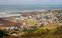
L'Agulhas (or Agulhas) is a coastal village and holiday resort in the Western Cape province of South Africa. Located just north of Cape Agulhas, the southernmost tip of the African mainland, it is the southernmost settlement in Africa. It is situated next to the town of Struisbaai and about 30 kilometres (20 mi) south of the regional centre of Bredasdorp. The name "Agulhas", Portuguese for "needles", is said to have been given to the cape because the compass-needle was seen to point due north, that is, with no magnetic deviation. The Agulhas Bank is reputed to be the richest fishing area in the Southern Hemisphere.[2]
Lighthouse

The Agulhas Lighthouse, the second-oldest working in South Africa, is at the southern end of the town. Designed by Colonel Charles Cornwell Michell in homage of the Pharos of Alexandria, the lighthouse was lit on March 1, 1849. Some 150 ships lay scattered along the South African coast, many due to the treacherous Agulhas Reef. It is in memory of the countless lives lost and to warn passing ships of the pending danger that the Agulhas Lighthouse was designed and built. The lighthouse was declared a National Monument in 1973.
Geography
Climate
L'Agulhas has a mild semi-arid climate (BSh, according to the Köppen climate classification, sometimes written BSn). Summers are mild and dry, winters are cool and wetter. The average annual precipitation is 276 mm (11 in), with most rainfall occurring mainly during winter.
| L'Agulhas | ||||||||||||||||||||||||||||||||||||||||||||||||||||||||||||
|---|---|---|---|---|---|---|---|---|---|---|---|---|---|---|---|---|---|---|---|---|---|---|---|---|---|---|---|---|---|---|---|---|---|---|---|---|---|---|---|---|---|---|---|---|---|---|---|---|---|---|---|---|---|---|---|---|---|---|---|---|
| Climate chart (explanation) | ||||||||||||||||||||||||||||||||||||||||||||||||||||||||||||
| ||||||||||||||||||||||||||||||||||||||||||||||||||||||||||||
| ||||||||||||||||||||||||||||||||||||||||||||||||||||||||||||
Another source gives different data, showing that it has a warm-summer Mediterranean climate (Köppen: Csb), with most precipitation falling in June.[3]
| Climate data for L'Agulhas | |||||||||||||
|---|---|---|---|---|---|---|---|---|---|---|---|---|---|
| Month | Jan | Feb | Mar | Apr | May | Jun | Jul | Aug | Sep | Oct | Nov | Dec | Year |
| Average high °C (°F) | 24 (75) |
23.8 (74.8) |
22.7 (72.9) |
20.9 (69.6) |
19.3 (66.7) |
18 (64) |
16.9 (62.4) |
17.1 (62.8) |
17.9 (64.2) |
19.2 (66.6) |
21.1 (70) |
23 (73) |
20.33 (68.5) |
| Daily mean °C (°F) | 20.6 (69.1) |
20.5 (68.9) |
19.6 (67.3) |
17.7 (63.9) |
15.8 (60.4) |
14.5 (58.1) |
13.6 (56.5) |
13.8 (56.8) |
14.6 (58.3) |
16 (61) |
17.8 (64) |
19.5 (67.1) |
17 (62.62) |
| Average low °C (°F) | 17.3 (63.1) |
17.3 (63.1) |
16.5 (61.7) |
14.5 (58.1) |
12.3 (54.1) |
11 (52) |
10.3 (50.5) |
10.5 (50.9) |
11.4 (52.5) |
12.9 (55.2) |
14.6 (58.3) |
16.1 (61) |
13.73 (56.71) |
| Average precipitation mm (inches) | 17 (0.67) |
23 (0.91) |
27 (1.06) |
63 (2.48) |
63 (2.48) |
69 (2.72) |
64 (2.52) |
56 (2.2) |
41 (1.61) |
40 (1.57) |
30 (1.18) |
24 (0.94) |
517 (20.34) |
| Source: Climate-Data.org[3] | |||||||||||||
See also
External links
References
- 1 2 3 4 "Main Place L'Agulhas". Census 2011.
- ↑ Raper, Peter E. (1987). Dictionary of Southern African Place Names. Internet Archive. p. 53. Retrieved 28 August 2013.
- 1 2 "Climate: L'Agulhas - Climate graph, Temperature graph, Climate table". Climate-Data.org. Retrieved 16 August 2013.
Municipalities and communities of Overberg District Municipality, Western Cape | ||
|---|---|---|
District seat: Bredasdorp | ||
| Cape Agulhas | .svg.png) | |
| Overstrand | ||
| Swellendam | ||
| Theewaterskloof | ||