La Amelia
 Location within Guatemala | |
| Location | Sayaxché |
|---|---|
| Region |
Petén Department, |
| Coordinates | 16°31′35″N 90°25′22″W / 16.52639°N 90.42278°W |
| History | |
| Abandoned | mid-9th century AD |
| Periods | Late Classic |
| Cultures | Maya |
| Events |
Conquered by: Dos Pilas |
| Site notes | |
| Excavation dates | 1937, 1984–1986, 1997 |
| Archaeologists | Edwin Shook, Antonia Foias |
| Architecture | |
| Architectural styles | Classic Maya |
 |
| Maya civilization |
|---|
| History |
| Preclassic Maya |
| Classic Maya collapse |
| Spanish conquest of the Maya |
La Amelia is a Pre-Columbian Maya archaeological site near Itzan, in the lower Pasión River region of the Petén Department of Guatemala. It formed a polity in the Late Classic (AD 600 to 830), and was involved in the war between Tikal and Calakmul followed, in 650, by the take over of Dos Pilas, leading to centuries of war until this region collapsed around 830, being the first of the Classic sites in this area to be abandoned.
Location
La Amelia is located on a series of low hills in the municipality of Sayaxché, 4 kilometres (2.5 mi) south of La Florida and the Pasión River. The site sits at a level of 150 to 160 metres (490 to 520 ft) above mean sea level. The low lying areas around the hills are prone to flooding.[1] The main site area is maintained as a forest park by the nearby village of San Francisco El Tumbo. More than 90 percent of the mounds at the site have been looted.[2]
History
La Amelia was a subordinate site in the Classic Period Petexbatún kingdom of Mutal that was first ruled from Dos Pilas and then from Aguateca.[3] The site is located to the northwest of Dos Pilas, and may have originally been called B'ahlam.[4] The rapidly expanding Dos Pilas kingdom conquered La Amelia in the early 8th century.[5] The occupational history of La Amelia appears to have been brief and limited to the Late Classic.[6]
In AD 802 the last known ruler of the kingdom, Tan Te' K'inich, supervised a ritual conducted by the ruler of La Amelia, Lachan K'awiil Ajaw Bot, the last reference anywhere to Tan Te' K'inich.[7] Lachan K'awiil Ajaw Bot, the local La Amelia king, is depicted on La Amelia Panel 2, dated to AD 804 and continued to raise monuments at the site, the last of which that can be dated was erected in 807 and contains the last reference to the Petexbatún kingdom of Mutal.[8] Lachan K'awiil Ajaw Bot is also mentioned on Panel 1 and Hieroglyphic Stairway 1 at the site. He is known to have been born on 25 June 760 and to have been enthroned on 1 May 802.[9]
La Amelia was abandoned some time in the middle of the 9th century AD.[10]
Modern history
The Carnegie Institution carried out investigations at the site in 1937. That project documented several carved stone monuments, and created a partial site map which was published by Sylvanus Morley in his 1938 volume The Inscriptions of Peten.[11] Yale University carried out further investigations from 1984 to 1986.[12]
A mapping and excavation project was conducted at the site by the La Amelia Archaeological Project in 1997. That work was directed by Dr. Antonia Foias of Williams College. During the summer 1997 field season, the La Amelia Archaeological Project completed mapping of the central site area and excavated several test units.[13]
The site
La Amelia is a small site covering an area of approximately 0.74 square kilometres (0.29 sq mi). The site is divided into four groups, two of which have monumental architecture, and a further 13 smaller residential groups.[14] The 1997 mapping project recorded a total of 71 structures at the site.[15] The central plaza area appears to have been focused around the "Group of the Three Pyramids" in the southern portion of the site. That group included three pyramids of between 3 and 8 metres (9.8 and 26.2 ft) in height, all of which have been severely damaged by looter trenches.[16]
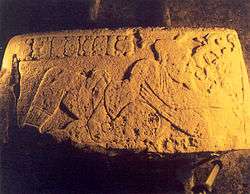
The "Group of the Hieroglyphic Stairway" is situated 0.5 kilometres (0.31 mi)north of the main plaza, in the northwest quadrant of the site, and was constructed principally by terracing and flattening the summit of a natural hill.[17] This group exhibits three frontal terraces, and an interior courtyard on the summit which is surrounded by six narrow range structures. Access to the lowest terrace is achieved via a 5-step monolithic stairway featuring limestone blocks carved with glyphs and scenes. Two carved panels (called alternately Stela 1 and Panel 2) originally decorated the front of the structure to either side of the stairway.[18]
Monuments

When Edwin M. Shook of the Carnegie Institution first documented the site of La Amelia in 1937, he noted the presence of six hieroglyphic blocks which functioned as risers along the uppermost level of the monolithic stairway.[19] This led him to identify the Hieroglyphic Stairway at the site, and to name the associated architectural group accordingly. A seventh carved block was recovered in 1997 from a test unit excavated on the plaza immediately southwest of the staircase.[20]
Three of the carved stones from the Hieroglyphic Stairway were entirely glyphic, while the four remaining stones (including the one recovered in 1997) feature reclining male figures along with short texts.[21] Stephen Houston documented one of the three glyphic stones, although no record exists of the other two.[22] Shook sketched the three steps he saw that depicted human figures, but did not include any details regarding the glyphic texts on those stones.[23] None of the six steps recorded by Shook remained in situ by 1997, and their ultimate disposition is unknown.[24]
The four carved steps featuring human figures from the Hieroglyphic Stairway at La Amelia all display images of simply-dressed males, who were likely ancestors of the site's ruler.[25] All four of these figures hold heads or masks of God K. The panel discovered in 1997 included a Calendar Round date of 2 Caban 2 Muan, and an associated text describing a ritual involving God K which took place on that date. The emblem glyph for the figure on this panel may be that of Tamarindito.[26]
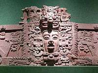
The carved panels which originally flanked the Hieroglyphic Stairway at La Amelia depict dancing rulers in full ceremonial costume, as well as glyphic texts. A lower register on each monument depicts a reclining jaguar which looks up at the dancing ruler.[27] Panel 2 records a date of AD 804 and depicts the ruler Lachan K'awiil Ajaw Bot dressed as a ballplayer.[28] Panel 2 now resides in front of the Mayor's building in Sayaxché. Stela 1 was originally located west of the Hieroglyphic Stairway and records a date of AD 807.[29] Stela 1 now resides at the National Museum of Anthropology and Ethnology in Guatemala City.
Notes
- ↑ Ortiz de León 2004
- ↑ Foias 1997
- ↑ Sharer & Traxler 2006, p. 409.
- ↑ Guenter, p.21
- ↑ Demarest et al 1991, p.229
- ↑ Ortiz de León 2004, p.21.
- ↑ Sharer & Traxler 2006, p.409
- ↑ Martin & Grube 2000, p. 65
- ↑ Martin & Grube 2000, p. 65
- ↑ Ortiz de León 2004, pp.21-22.
- ↑ Morley 1938
- ↑ Ortiz de León 2004, p.21.
- ↑ Foias 1997
- ↑ Ortiz de León 2004, p.21.
- ↑ Foias 1997
- ↑ Foias 1997
- ↑ Foias 1997
- ↑ Foias 1997
- ↑ Morley 1937
- ↑ Foias 1997
- ↑ Foias 1997
- ↑ Houston 1993
- ↑ Morley 1937
- ↑ Foias 1997
- ↑ Foias 1997
- ↑ Foias 1997
- ↑ Morley 1938; Houston 1993
- ↑ Martin & Grube 2000; Zender 2004
- ↑ Tourtellot & González 2005
References
- Demarest, Arthur A.; Stephen Houston; Kevin Johnston (1991). "Proyecto Arqueológico Petexbatun: Nuevas perspectivas sobre el sistema de guerra Maya y el colapso" (versión digital). II Simposio de Investigaciones Arqueológicas en Guatemala, 1988 (edited by J.P. Laporte, S. Villagrán, H. Escobedo, D. de González and J. Valdés) (in Spanish). Guatemala: Museo Nacional de Arqueología y Etnología: 226–231. Retrieved 2009-11-18.
- Demarest, Arthur A.; Héctor L. Escobedo (1998). "Acontecimientos, procesos y movimientos de poblaciones en el Clásico Terminal y el colapso Maya" (versión digital). XI Simposio de Investigaciones Arqueológicas en Guatemala, 1997 (edited by J.P. Laporte and H. Escobedo) (in Spanish). Guatemala: Museo Nacional de Arqueología y Etnología: 812–826. Retrieved 2009-11-18.
- Foias, Antonia E. (1997). La Amelia Archaeological Project, Final Report: 1997 Field Season. Williamstown. MA: Williams College.
- Guenter, Stanley Paul. "The Inscriptions of Dos Pilas Associated with B'ajlaj Chan K'awiil" (PDF online publication). Mesoweb articles. Mesoweb: An Exploration of Mesoamerican Cultures. Retrieved 2009-01-25.
- Houston, Stephen D. (1993). Hieroglyphs and History at Dos Pilas: Dynastic Politics of the Classic Maya. Austin: University of Texas Press. ISBN 0-292-73855-2.
- Martin, Simon; Nikolai Grube (2000). Chronicle of the Maya Kings and Queens: Deciphering the Dynasties of the Ancient Maya. London and New York: Thames & Hudson. ISBN 0-500-05103-8. OCLC 47358325.
- Morley, Sylvanus Griswold (1938). The Inscriptions of Peten. Washington, D.C.: Carnegie Institution of Washington. OCLC 551558.
- Ortiz de León, Jorge Mario (September 2004). "Estudio del desarrollo de una tradición: las escalinatas jeroglíficas de la región de Petexbatun y Usumacinta" (PDF online publication) (in Spanish). Guatemala Ciy: Universidad de San Carlos de Guatemala, Escuela de Historia. Retrieved 2009-11-18.
- Sharer, Robert J.; Loa P. Traxler (2006). The Ancient Maya (6th (fully revised) ed.). Stanford, CA: Stanford University Press. ISBN 0-8047-4817-9. OCLC 57577446.
- Tokovinine, Alexandre (2002). "Divine Patrons of the Maya Ballgame" (PDF online publication). Mesoweb Articles. Mesoweb. Retrieved 2007-11-01.
- Tourtellot, Gair; Jason J. González (2005). "The Last Hurrah: Continuity and Transformation at Seibal". In Arthur A. Demarest, Prudence M. Rice and Don S. Rice (eds.). The Terminal Classic in the Maya lowlands: Collapse, transition, and transformation. Boulder: University Press of Colorado. pp. 60–82. ISBN 0-87081-822-8. OCLC 61719499.
- Zender, Marc (Spring 2004). "Glyphs for "Handspan" and "Strike" in Classic Maya Ballgame Texts" (PDF online facsimile). The PARI Journal. San Francisco, CA: Pre-Columbian Art Research Institute. IV (4): 1–9. ISSN 1531-5398. OCLC 44780248.
Coordinates: 16°31′35″N 90°25′22″W / 16.52639°N 90.42278°W
