La Tuque, Quebec
| La Tuque | ||
|---|---|---|
| City | ||
|
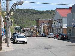
Downtown La Tuque | ||
| ||
|
Motto: Industriis et labore cresco (Industry and work to grow) | ||
 Location within Les Chenaux RCM. | ||
 La Tuque Location in central Quebec. | ||
| Coordinates: 47°26′N 72°47′W / 47.433°N 72.783°WCoordinates: 47°26′N 72°47′W / 47.433°N 72.783°W[1] | ||
| Country |
| |
| Province |
| |
| Region | Mauricie | |
| RCM | None | |
| Settled | 1850s | |
| Constituted | March 26, 2003 | |
| Government[2] | ||
| • Mayor | Normand Beaudoin | |
| • Federal riding | Saint-Maurice—Champlain | |
| • Prov. riding | Laviolette | |
| Area[2][3] | ||
| • City | 28,098.60 km2 (10,848.93 sq mi) | |
| • Land | 25,113.70 km2 (9,696.45 sq mi) | |
| • Urban[4] | 25.84 km2 (9.98 sq mi) | |
| Population (2011)[3] | ||
| • City | 11,227 | |
| • Density | 0.4/km2 (1/sq mi) | |
| • Urban[4] | 9,506 | |
| • Urban density | 367.9/km2 (953/sq mi) | |
| • Pop 2006-2011 |
| |
| • Dwellings | 7,373 | |
| Time zone | EST (UTC−5) | |
| • Summer (DST) | EDT (UTC−4) | |
| Postal code(s) | G9X | |
| Area code(s) | 819 | |
| Highways |
| |
| Website |
www latuque | |
.svg.png)
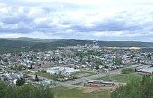
La Tuque is a city located in north-central Quebec, Canada, on the Saint-Maurice River, between Trois-Rivières and Chambord. The population was 11,227 at the Canada 2011 Census, most of which live within the urban area.
While the urban area of La Tuque is relatively small, as of 2012, its entire territory is the largest municipality in Canada. It consists of almost all the entire former regional county municipality of Le Haut-Saint-Maurice, and includes the settlements of Carignan, La Croche, Fitzpatrick, Oskelaneo, Parent, Rapide-Blanc, Rivière-aux-Rats, and Sanmaur. Enclosed by but administratively not part of the city are the three Indian Reserves of Coucoucache, Obedjiwan, and Wemotaci.
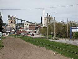
The local economy centres on pulp and paper; the city has a pulp-milling centre as well as a major hydroelectric station. As the gateway to the upper Mauricie, La Tuque's economy also offers outdoor tourism opportunities and caters to hunting and fishing trips in its large hinterland; the city is known as the Queen of Haute-Mauricie and the Classique internationale de canots de la Mauricie canoeing race begins at La Tuque.
Etymology
The name, which dates to the eighteenth century, originates from a nearby rock formation which resembles the well-known French-Canadian hat known as the tuque.
The hat-shaped mountain which gaves its name to the town of La Tuque, is located between the Saint-Maurice River (left bank) and paper mill Smurfit-Stone plant. The summit of this mountain is about 245 metres. It is located 200 metres from the river and about 400 metres upstream (northeast side) of the La Tuque hydroelectric power plant.
In 1823-24, the explorer François Verreault described the location as:
un Portage nommé Ushabatshuan (le courant trop fort pour le sauter). Les Voyageurs le nomment la Tuque, à cause d'une Montagne haute, dont le pic ressemble à une Tuque. Ce portage est d'une lieue, avec des fortes côtes à monter."a portage named Ushabatshuan ('the rapids too strong to jump'). The voyageurs call it La Tuque, due to a tall mountain whose peak resembles a "tuque." The portage is a league long, and climbs steep slopes."[1]
In Canada, a tuque ("tuque" in French) is a knitted cap, often with a tassel at the top, worn as a head covering in winter. The US equivalent is a watch, knit, or stocking cap.
History
The territory of La Tuque was originally inhabited by Atikamekw indigenous people. In the early 1850s, settlers were drawn to the area to exploit the forest resources. The La Tuque Post Office opened in 1887, but the area remained isolated from the rest of the Mauricie until the early 1900s when the National Transcontinental Railway was built, prompting industrial development and the growth of a community on the east bank of the Saint-Maurice River where there was a large set of falls.[1]
On November 15, 1909, the Village Municipality of La Tuque was incorporated, with Achille Comeau as first mayor. A few months later on April 4, 1910, the Village Municipality of La Tuque Falls was formed, with Wenceslas Plante as first mayor. Less than one year later in March 1911, both villages merged to form the Town of La Tuque, with Wenceslas Plante as first mayor.[1][5]
In the 1940s, the hydro-electric generating station on the Saint-Maurice River was built, requiring the partial destruction of the rock formation that gave the town its name.[1]
In 1972, the Municipality of Haute-Mauricie was formed out of portions from the unincorporated Carignan and Malhiot Townships, in the proximity of the Saint-Maurice Wildlife Reserve. However, its low population and constantly rising administrative costs led to the merger of Haute-Mauricie with La Tuque in August 1993.[1]
On March 26, 2003, Le Haut-Saint-Maurice Regional County Municipality was dissolved and all its municipalities and unorganized territories were amalgamated into the new City of La Tuque, thereby becoming the largest municipality with city status in land area in Quebec, and largest in Canada (38,000 km2). On January 1, 2006, the municipalities of La Bostonnais and Lac-Édouard separated and were reestablished.[1]
In May 2010, some 120 forest fires broke out around La Tuque, burning until June. Smoke from these fires reached portions of Eastern Ontario and southern Quebec, including the cities of Ottawa and Montreal, as well as the northern US states.
Climate
| Climate data for La Tuque, Quebec | |||||||||||||
|---|---|---|---|---|---|---|---|---|---|---|---|---|---|
| Month | Jan | Feb | Mar | Apr | May | Jun | Jul | Aug | Sep | Oct | Nov | Dec | Year |
| Record high °C (°F) | 12.2 (54) |
12.0 (53.6) |
21.1 (70) |
32.0 (89.6) |
35.0 (95) |
38.0 (100.4) |
37.2 (99) |
40.0 (104) |
33.3 (91.9) |
29.4 (84.9) |
21.1 (70) |
12.0 (53.6) |
40 (104) |
| Average high °C (°F) | −8.5 (16.7) |
−5.1 (22.8) |
1.3 (34.3) |
9.3 (48.7) |
18.2 (64.8) |
23.3 (73.9) |
25.3 (77.5) |
23.9 (75) |
17.9 (64.2) |
10.9 (51.6) |
2.3 (36.1) |
−4.8 (23.4) |
9.5 (49.08) |
| Daily mean °C (°F) | −14.8 (5.4) |
−12.0 (10.4) |
−5.2 (22.6) |
3.4 (38.1) |
11.1 (52) |
16.4 (61.5) |
18.8 (65.8) |
17.6 (63.7) |
12.3 (54.1) |
6.0 (42.8) |
−1.7 (28.9) |
−9.8 (14.4) |
3.51 (38.31) |
| Average low °C (°F) | −21.0 (−5.8) |
−18.8 (−1.8) |
−11.7 (10.9) |
−2.6 (27.3) |
4.0 (39.2) |
9.4 (48.9) |
12.2 (54) |
11.3 (52.3) |
6.6 (43.9) |
1.1 (34) |
−5.6 (21.9) |
−14.8 (5.4) |
−2.49 (27.52) |
| Record low °C (°F) | −44.4 (−47.9) |
−42.8 (−45) |
−40.0 (−40) |
−24.4 (−11.9) |
−9.4 (15.1) |
−2.8 (27) |
0.0 (32) |
−0.5 (31.1) |
−7.0 (19.4) |
−14.4 (6.1) |
−26.7 (−16.1) |
−42.8 (−45) |
−44.4 (−47.9) |
| Average precipitation mm (inches) | 57.8 (2.276) |
46.5 (1.831) |
54.8 (2.157) |
54.9 (2.161) |
84.4 (3.323) |
93.5 (3.681) |
129.9 (5.114) |
93.7 (3.689) |
94.9 (3.736) |
82.1 (3.232) |
73.6 (2.898) |
52.9 (2.083) |
919 (36.181) |
| Average rainfall mm (inches) | 7.3 (0.287) |
10.1 (0.398) |
28.0 (1.102) |
49.2 (1.937) |
84.3 (3.319) |
93.5 (3.681) |
129.9 (5.114) |
93.7 (3.689) |
94.9 (3.736) |
80.4 (3.165) |
52.0 (2.047) |
9.5 (0.374) |
732.8 (28.849) |
| Average snowfall cm (inches) | 50.5 (19.88) |
36.4 (14.33) |
26.8 (10.55) |
5.8 (2.28) |
0.1 (0.04) |
0 (0) |
0 (0) |
0 (0) |
0 (0) |
1.7 (0.67) |
21.6 (8.5) |
43.4 (17.09) |
186.3 (73.34) |
| Average precipitation days (≥ 0.2 mm) | 13.3 | 10.5 | 10.6 | 10.8 | 12.5 | 14.0 | 14.8 | 14.5 | 15.3 | 14.2 | 13.0 | 13.8 | 157.3 |
| Average rainy days (≥ 0.2 mm) | 1.3 | 1.3 | 4.6 | 9.8 | 13.5 | 14.1 | 15.4 | 14.9 | 16.2 | 14.5 | 8.4 | 2.1 | 116.1 |
| Average snowy days (≥ 0.2 cm) | 12.3 | 9.9 | 6.9 | 2.3 | 0.1 | 0 | 0 | 0 | 0 | 0.6 | 6.1 | 12.5 | 50.7 |
| Source: Weatherbase[6] | |||||||||||||
Demographics
Population
| Canada census – La Tuque, Quebec community profile | |||
|---|---|---|---|
| 2011 | 2006 | 2001 | |
| Population: | 11,227 (-5.0% from 2006) | 11,821 (-5.3% from 2001) | 11,298 (-6.6% from 1996) |
| Land area: | 25,113.70 km2 (9,696.45 sq mi) | 25,104.59 km2 (9,692.94 sq mi) | 579.46 km2 (223.73 sq mi) |
| Population density: | 0.4/km2 (1.0/sq mi) | 0.5/km2 (1.3/sq mi) | 19.5/km2 (51/sq mi) |
| Median age: | 48.6 (M: 47.9, F: 49.2) | 46.1 (M: 45.3, F: 46.8) | 42.3 (M: 41.4, F: 43.4) |
| Total private dwellings: | 7,373 | 6,438 | 5,319 |
| Median household income: | $45,874 | $42,312 | $38,752 |
| References: 2011[3] 2006[7] 2001[8] | |||
| Historical Census Data - La Tuque, Quebec[9] | |||||||||||||||||||||||||||||
|---|---|---|---|---|---|---|---|---|---|---|---|---|---|---|---|---|---|---|---|---|---|---|---|---|---|---|---|---|---|
|
|
| |||||||||||||||||||||||||||
(A) adjustment due to boundary change. | |||||||||||||||||||||||||||||
Language
| Canada Census Mother Tongue - La Tuque, Quebec[9] | ||||||||||||||||||
|---|---|---|---|---|---|---|---|---|---|---|---|---|---|---|---|---|---|---|
| Census | Total | French |
English |
French & English |
Other | |||||||||||||
| Year | Responses | Count | Trend | Pop % | Count | Trend | Pop % | Count | Trend | Pop % | Count | Trend | Pop % | |||||
| 2011 |
11,010 |
10,455 | |
94.96% | 180 | |
1.63% | 50 | |
0.45% | 325 | |
2.95% | |||||
| 2006 |
11,590 |
11,080 | |
95.60% | 190 | |
1.64% | 20 | |
0.17% | 300 | |
2.59% | |||||
| 2001 |
11,160 |
10,695 | |
95.83% | 180 | |
1.61% | 60 | |
0.54% | 225 | |
2.02% | |||||
| 1996 |
11,965 |
11,405 | n/a | 95.32% | 390 | n/a | 3.26% | 30 | n/a | 0.25% | 140 | n/a | 1.17% | |||||
Transportation
The main highway is Quebec Route 155 that connects La Tuque with Shawinigan to the south and the Saguenay–Lac-Saint-Jean region to the north. Numerous forest roads provide access to remote hunting and fishing camps, and the village of Parent is accessible by a 175 kilometres (109 mi) long gravel road from Mont-Saint-Michel in the Laurentides region.
The Canadian National Railway dissects La Tuque's territory. This railway, built in 1910 by the National Transcontinental Railway, connected Quebec City to the Canadian Prairies and goes through vast wilderness areas of northern Quebec and Ontario. While it was intended to ship grain from the prairies to the Port of Quebec and to open up virgin territories, it never carried much rail traffic but is still serviced by Via Rail at the La Tuque railway station and Parent railway station, with request stops at Fitzpatrick, Oskelaneo, and Clova. Other sidings along the line are Casey, Hibbard, Cann, Sanmaur, Vandry, Windigo, and Rapide-Blanc-Station.
The La Tuque Airport is located directly south of the town's centre on Route 155.
List of mayors
The Mayor is the municipality's highest elected official. La Tuque has had fifteen mayors, since its incorporation as a city.[10]
| # | Mayor | Taking Office | Leaving |
|---|---|---|---|
| 1 | Wenceslas Plante | 1911 | 1915 |
| 2 | Alphondor Roy | 1915 | 1920 |
| 3 | Donat E. Hardy | 1920 | 1921 |
| 4 | Wellie Juneau | 1921 | 1921 |
| 5 | Réal Gravel | 1921 | 1923 |
| 1 | Wenceslas Plante | 1923 | 1927 |
| 6 | François-Xavier Lamontagne | 1927 | 1935 |
| 7 | Joseph-Omer Journeault [11] | 1935 | 1944 |
| 8 | Omer Veillette | 1944 | 1947 |
| 7 | Joseph-Omer Journeault | 1947 | 1951 |
| 9 | Léo-Joffre Pilon [12] | 1951 | 1955 |
| 10 | J.-Onésime Dallaire | 1955 | 1961 |
| 11 | Lucien Filion [13] | 1961 | 1985 [14] |
| 12 | Clément Filion | 1985 | 1985 |
| 13 | André Duchesneau | 1985 | 1991 |
| 14 | Gaston Fortin [15] | 1991 | 2003 |
| 15 | Réjean Gaudreault [16] | 2003 | 2009 |
| 16 | Normand Beaudoin | 2009 |
Famous residents
- Marcel Béliveau : animator, humourist and actor (November|19|1939/May|28|2009).
- Jean-Jacqui Boutet, actor
- Mathieu Fortin: writer.
- Maude Guérin, actress
- Steven Guilbault, environmentalist
- Félix Leclerc, poet and singer (August|2|1914 / August|8|1988)
- Sylvie Roy, politician
- Dominique Trottier, TV reporter
See also

- La Tuque (urban agglomeration)
- La Tuque Airport
- La Tuque Water Aerodrome
- La Tuque railway station
- Mauricie
- Municipal reorganization in Quebec
Rivers
- Saint-Maurice River
- Vermillon River (La Tuque)
- Manouane River (La Tuque)
- Croche River (La Tuque)
- Bostonnais River
- Little Bostonnais River
- Trenche River
- Lake Ventadour (La Tuque)
Lakes
- Lake Édouard (Quebec)
- Lake Kiskissink
- Lake of La Trenche
- Lake Wayagamac
- Grand Lake Bostonnais
- Lake Ventadour (La Tuque)
Reservoirs
Zecs
- Zec de la Croche
- Zec de la Bostonnais
- Zec de la Bessonne
- Zec Borgia
- Zec Frémont
- Zec du Gros Brochet
- Zec Jeannotte, Québec
- Zec Kiskissink
- Zec Menokeosawin
- Zec Tawachiche
- Zec Wessonneau
Indian Reserves
Hamlets
References
- 1 2 3 4 5 6 7 "La Tuque (Ville)" (in French). Commission de toponymie du Québec. Retrieved 2010-03-04.
- 1 2 Ministère des Affaires municipales, des Régions et de l'Occupation du territoire - Municipalité: La Tuque - Répertoire des municipalités du Québec, retrieved 2010-03-04
- 1 2 3 "2011 Community Profiles". Canada 2011 Census. Statistics Canada. July 5, 2013. Retrieved 2014-04-27.
- 1 2 La Tuque (Population Centre), Quebec census profile, 2011
- ↑ "Ville de La Tuque - Liste des maires 1909 à 2013" (PDF).
- ↑ http://www.weatherbase.com/weather/weatherall.php3?s=107047&units=
- ↑ "2006 Community Profiles". Canada 2006 Census. Statistics Canada. March 30, 2011. Retrieved 2014-04-27.
- ↑ "2001 Community Profiles". Canada 2001 Census. Statistics Canada. February 17, 2012. Retrieved 2014-04-27.
- 1 2 Statistics Canada: 1996, 2001, 2006, 2011 census
- ↑ Liste des maires, Ville de La Tuque, 1909 à 2009
- ↑ Journeault ran as a Bloc Populaire candidate in the provincial election of 1944 in the district of Laviolette. He finished third.
- ↑ Pilon ran as a Liberal candidate in the 1952 and the 1956 provincial elections in the district of Laviolette. He was each time defeated by incumbent Romulus Ducharme.
- ↑ Lucien Filion ran as a Union Nationale candidate in the provincial election of 1970 in the district of Laviolette. He finished third.
- ↑ Lucien Filion dies in office on September 22, 1985.
- ↑ Fortin ran as a Union Nationale candidate in the provincial election of 1976 and as a Liberal candidate in the provincial election of 1994 in the district of Laviolette. Each time he lost to Jean-Pierre Jolivet.
- ↑ Gaudreault admits that he generally supports the Parti Québécois in provincial elections, even though municipal elections in La Tuque are officially on a non-partisan basis. Patrick Vaillancourt, Le maire Gaudreault approché par le PQ, L'Hebdo Mékinac des Chenaux, November 13, 2008
External links
| Wikimedia Commons has media related to La Tuque, Québec. |
| Wikivoyage has a travel guide for La Tuque. |
- (French) City of La Tuque official website
- (French) La Tuque (Tourisme Haut-Saint-Maurice)
- (French) service de publicitées...
- (French) Ville de La Tuque (Haut-Saint-Maurice)
- (French) Eau Quai Saint-Maurice (Kayaking on St. Maurice River)
- (English) Tourisme Mauricie Regional tourist office
- (English) Ski area profile in English
 |
Baie-James | Lac-Ashuapmushuan | Lac-Bouchette Lac-Moncouche |
|
| Senneterre | |
Lac-Jacques-Cartier Lac-Croche Lac-Édouard La Bostonnais | ||
| ||||
| | ||||
| Dépôt-Échouani | Lac-de-la-Bidière, Lac-Bazinet, Baie-Obaoca, Lac-Normand, Trois-Rives, Lac-Masketsi | Lac-Lapeyrère, Linton |
| Cities | |
|---|---|
| Municipalities | |
| Native reserves | |
| |