Lafayette Avenue Bridge
| Lafayette Avenue Bridge | |
|---|---|
 The East Bridge (The Drawbridge) | |
| Coordinates | 43°34′47″N 83°54′00″W / 43.5797°N 83.90°W |
| Carries |
|
| Crosses | Saginaw River |
| Locale | Bay City, Michigan |
| Official name | Lafayette Avenue Bridge |
| Maintained by | Michigan Department of Transportation |
| Characteristics | |
| Design |
Girder Bridge (West Bridge) Bascule bridge (East Bridge) |
| Total length |
310 feet (West Bridge) 436 feet (East Bridge) |
| History | |
| Opened | 1938 |
| Statistics | |
| Toll | None |
|
Bay City Bascule Bridge | |
|
Formerly listed on the U.S. National Register of Historic Places | |
 | |
| NRHP Reference # | 99001465[1] |
| Significant dates | |
| Added to NRHP | November 30, 1999 |
| Removed from NRHP | April 20, 2015[2] |
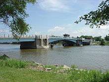
The Lafayette Avenue Bridge, formerly listed on the National Register of Historic Places as the Bay City Bascule Bridge,[3] is a set of two small bridges located in Bay City, Michigan. It carries M-13 and M-84 over the Saginaw River. It is maintained by the Michigan Department of Transportation, and is currently the oldest of Bay City's four modern drawbridges.[4] It was listed on the National Register of Historic Places on November 30, 1999,[3] but was removed from the Register in 2015.[2]
Heading east, the first bridge carries M-13/M-84 from the western shore of the river to Middle Ground Island. The second bridge, a small drawbridge carries the road from the island to the eastern shore of the river. M-13/M-84 is known as Salzburg Avenue on the west side of the river, and Lafayette Avenue on the east, which is where the bridge's name comes from.
History
The Lafayette Avenue Bridge replaced an earlier bridge built at the same location in 1876. This bridge was condemned in 1934, and a temporary pontoon swing bridge was immediately installed at the site. The City of Bay City began surveying the condition of its bridges in 1936 and developed a plan to replace the Lafayette Avenue Bridge and rehabilitate the Belinda Street and Cass Avenue Bridges. However, funding was scarce as the country was in the midst of the Great Depression, though funding would eventually come through the Public Works Administration, part of President Franklin D. Roosevelt's New Deal. The current Lafayette Avenue Bridge was completed and opened in 1938. It became the city's southernmost bridge over the Saginaw River in 1955 after the removal of the Cass Avenue Bridge.[4][5]
Gallery
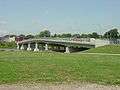 The West Bridge
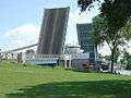 The drawbridge with a freighter passing underneath
 The drawbridge with the bascule spans partially open
See also
- List of bridges on the National Register of Historic Places in Michigan
- National Register of Historic Places listings in Bay County, Michigan
References
- ↑ National Park Service (March 13, 2009). "National Register Information System". National Register of Historic Places. National Park Service.
- 1 2 "Weekly list of actions taken on properties [on the National Register of Historic Places]: 4/20/15 through 4/24/15". National Park Service. May 1, 2015. Retrieved 2016-05-22.
- 1 2 Staff. "Bay City Bascule Bridge". State Historic Preservation Office. Michigan State Housing Development Authority. Retrieved April 16, 2013.
- 1 2 Staff (May 9, 2002). "M-13 & M-84 / E. Channel Saginaw River". Historic Bridge Listing. Michigan Department of Transportation.
- ↑ "Bay County, MI - Historical Events Timeline". Bay-Journal. Retrieved 23 July 2016.
External links
| Crossings of the Saginaw River | ||||
|---|---|---|---|---|
| ||||