Lake Abaya
| Lake Abaya | |
|---|---|
.jpg) | |
 | |
| Coordinates | 6°26′N 37°53′E / 6.433°N 37.883°ECoordinates: 6°26′N 37°53′E / 6.433°N 37.883°E |
| Primary inflows | Bilate River |
| Basin countries | Ethiopia |
| Max. length | 60 km |
| Max. width | 20 km |
| Surface area | 1162 km² |
| Average depth | 7.1 m |
| Max. depth | 13.1 m |
| Water volume | 8.2 km3 (2.0 cu mi) |
| Surface elevation | 1285 m |
| Settlements | Arba Minch |
- For the Muslim garment, see Abaya.
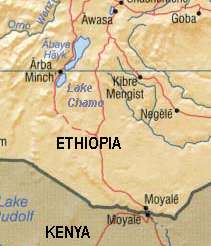
Lake Abaya (Abaya Hayk in Amharic) is a lake in the Southern Nations, Nationalities, and Peoples' Region of Ethiopia.
In 1896 Lake Abaya was renamed "Lake Margherita" after the Queen Margherita of Savoy, wife of King Humbert I of Italy by the Italian explorer Vittorio Bottego who first explored the region. The name "Lake Margherita" is still used in Italy while is now obsolete in other countries.[1]
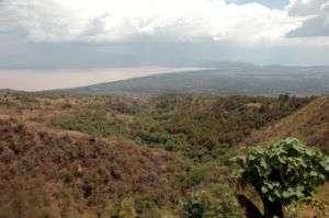
Lake Abaya is located in the Main Ethiopian Rift, east of the Guge Mountains. It is fed on its northern shore by the Bilate which rises on the southern slopes of Mount Gurage, and the Gidabo. The town of Arba Minch lies on its southwestern shore, and the southern shores are part of the Nechisar National Park. Just to the south is Lake Chamo. Lake Abaya is 60 kilometers long and 20 wide,[2] with a surface area of 1162 square kilometers.[3] It has a maximum depth of 13.1 meters and is at an elevation of 1285 meters.[3] There are a number of islands in this lake, the largest being Aruro;[4] others include Gidicho, Welege, Galmaka, and Alkali. The lake is red due to a high load of suspended sediments.[5] Lake Abaya does not always have an outflow, but in some years it overflows into Lake Chamo.
Savanna, known for its wildlife and birdlife surrounds the lake, which is also fished by local people. According to the Ethiopian Department of Fisheries and Aquaculture, 412 tonnes of fish are landed each year, which the department estimates is 69% of its sustainable amount.[6]
See also
Notes
- ↑ Mack Smith, Denis. Mussolini’s Roman Empire. New York: Viking, 1976.
- ↑ Statistical Abstract of Ethiopia for 1967/68
- 1 2 Baxter, R. M. Lake Morphology and Chemistry. in Taylor, W.D. and Tudorancea, C., eds. Ethiopian Rift Valley Lakes. Leiden: Backhuys Publishers, 2002.
- ↑ "Local History in Ethiopia" The Nordic Africa Institute website (accessed 5 November 2007)
- ↑ A. T. Grove; F. A. Street; A. S. Goudie, 1975: "Former Lake Levels and Climatic Change in the Rift Valley of Southern Ethiopia," Geographical Journal 141, 177-194
- ↑ "Information on Fisheries Management in the Federal Democratic Republic of Ethiopia" (report dated January, 2003)