Lake Great Falls
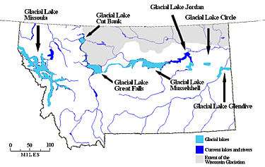
Lake Great Falls was a prehistoric proglacial lake which existed in what is now central Montana in the United States between 15,000 BCE and 11,000 BCE.[1][2][3] Centered on the modern city of Great Falls, Montana, Glacial Lake Great Falls extended as far north as Cut Bank, Montana, and as far south as Holter Lake.[4] At present-day Great Falls, the Glacial Lake Great Falls reached a depth of 600 feet (183 metres).[5]
Approximately 1.5 million years ago, the Missouri River, the Yellowstone River and Musselshell River all flowed northward into a terminal lake.[6][7] During the last glacial period, the Laurentide and Cordilleran ice sheets pushed these lakes and rivers southward.[1][6] Between 15,000 BCE and 11,000 BCE, the Laurentide ice sheet blocked the Missouri River and created Glacial Lake Great Falls.[1][2][3]
About 13,000 BCE, as the glacier retreated, Glacial Lake Great Falls emptied catastrophically in a glacial lake outburst flood.[3] The meltwater poured through the Highwood Mountains and eroded the hundred mile-long, 500-foot-deep (150 m) Shonkin Sag—one of the most famous prehistoric meltwater channels in the world.[8]
See also
References
- 1 2 3 Montagne J.L. "Quaternary System, Wisconsin Glaciation." Geologic Atlas of the Rocky Mountain Region. Denver: Rocky Mountain Association of Geologists, 1972.
- 1 2 Hill, Christopher L. and Valppu, Seppo H. "Geomorphic Relationships and Paleoenvironmental Context of Glaciers, Fluvial Deposits, and Glacial Lake Great Falls, Montana." Current Research in the Pleistocene. 14 (1997); Hill, Christopher L. "Pleistocene Lakes Along the Southwest Margin of the Laurentide Ice Sheet." Current Research in the Pleistocene. 17 (2000); Hill, Christopher L. and Feathers, James K. "Glacial Lake Great Falls and the Late-Wisconsin-Episode Laurentide Ice Margin." Current Research in the Pleistocene. 19 (2002); Reynolds, Mitchell W. and Brandt, Theodore R. Geologic Map of the Canyon Ferry Dam 30' x 60' Quadrangle, West-Central Montana: U.S. Geological Survey Scientific Investigations Map 2860, scale 1:100,000. Scientific Investigations Map 2860. Washington, D.C.: U.S. Geologic Survey, 2005.
- 1 2 3 Feathers, James K. and Hill, Christopher L. "Luminescence Dating of Glacial Lake Great Falls, Montana, U.S.A." XVI International Quaternary Association Congress. Stratigraphy and Geochronology Session. International Quaternary Association, Reno, 2003.
- ↑ Kidston, Martin J. "Prehistoric Find." Helena Independent Record. June 20, 2004.
- ↑ Alt, David and Hyndman, Donald W. Roadside Geology of Montana. Missoula, Mont.: Mountain Press Publishing, 1986. ISBN 0-87842-202-1; Stickney, Michael C. "Quaternary Geology and Faulting in the Helena Valley." In 1987 Guidebook for the Helena Area, West-Central Montana: Guidebook for the 12th Annual Field Conference. Richard B. Berg and Ray H. Breuninger, eds. Montana Bureau of Mines and Geology Special Publication 95. Helena, Mont.: Montana Bureau of Mines and Geology, 1987.
- 1 2 Clawson, Roger and Shandera, Katherine A. Billings: The City and the People. Helena, Mont.: Farcountry Press, 1998. ISBN 1-56037-037-8
- ↑ McRae, W.C. and Jewell, Judy. Moon Montana. 7th ed. Cambridge, Mass.: PublicAffairs, 2009. ISBN 1-59880-014-0
- ↑ Axline, Jon and Bradshaw, Glenda Clay. Montana's Historical Highway Markers. Rev. ed. Helena, Mont.: Montana Historical Society, 2008. ISBN 0-9759196-4-4; Bowman, Isaiah. "Forest Physiography: Physiography of the United States and Principles of Soils in Relation to Forestry." American Environmental Studies. Reprint ed. Charles Gregg, ed. New York: Arno Press, 1970. ISBN 0-405-02659-5
Coordinates: 47°30′13″N 111°17′11″W / 47.50361°N 111.28639°W