Lake Lovozero
| Lake Lovozero | |
|---|---|
 | |
| Location | Kola Peninsula, Murmansk Oblast |
| Coordinates | 67°54′N 35°12′E / 67.900°N 35.200°ECoordinates: 67°54′N 35°12′E / 67.900°N 35.200°E |
| Type | natural lake, reservoir |
| Basin countries | Russia |
| Surface area | 200 km2 (77 sq mi) |
| Average depth | 5.7 m (19 ft) |
| Max. depth | 35 m (115 ft) |
| Residence time | 10 months |
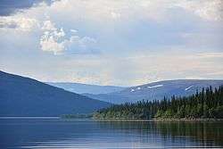
Lake Lovozero (Kildin Sami: Луяввьр, Skolt Sami: Luujäuˊrr, Russian: Ловозеро, Northern Sami: Lujávri, Finnish: Luujärvi) is located on the Kola Peninsula, in Murmansk Oblast within the Barents Sea basin and ensures runoff from the Voronya River. Area: 200 km², average depth is 5.7 metres, maximal 35 m. Annual fluctuations do not exceed 1 m, and the average period of water renewal is about 10 months. The lake has a winding coastline and many peninsulas and islands. The area surrounding the lake, e.g. the Lovozerskiye Tundras is commonly known as "Ловозёрье" in Russian (Lovozerye, Lovozyorye).
In 1970, two hydroelectric power plants were built on the Voronya River at Serebryansk, about 100 kilometers downstream from the lake. The dam at the power plant created a reservoir on the Voronya with the same waterlevel as Lake Lovozero, effectively turning the two bodies of water into one.