Lake Schwerin
| Lake Schwerin (Schweriner See) | |
|---|---|
 | |
| Location | Mecklenburg-Western Pomerania |
| Coordinates | 53°38′N 11°28′E / 53.633°N 11.467°ECoordinates: 53°38′N 11°28′E / 53.633°N 11.467°E |
| Type | eutrophic |
| Primary outflows | Wallensteingraben, Stör Canal |
| Basin countries | Germany |
| Max. length | 21 km (13 mi) |
| Max. width | 6 km (3.7 mi) |
| Surface area | 61.54 km2 (23.76 sq mi) |
| Average depth | 12.8 m (42 ft) |
| Max. depth | 52.4 m (172 ft) |
| Residence time | 10.1 years |
| Surface elevation | 37.6 m (123 ft) |
| Settlements | Schwerin, Bad Kleinen |
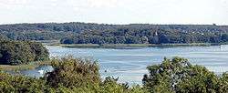
Lake Schwerin[1][2] (German: Schweriner See) is a lake in Mecklenburg-Vorpommern, northern Germany. It was named after the city Schwerin, on its southwestern shore. The smaller town Bad Kleinen is on the north shore of the lake. Its surface is approximately 61.54 square kilometres (23.76 sq mi), and its maximum depth is 52.4 metres (172 ft). The natural outflow of the lake is the (channelized) river Stör, a tributary of the Elde, and part of the Elbe watershed. The Wallensteingraben, a 16th-century canal, connects the lake with the Baltic Sea at Wismar.
Gallery
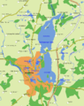 Map of Schwerin and its lakes, most dominantly the Lake Schwerin with its inner and outer lake area
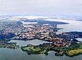 Aerial view of Schwerin on the lakes
 Schwerin Castle on its own island in the Lake Schwerin
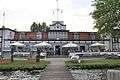 Yachting Club at Lake Schwerin
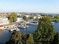 White Fleet, cruiseships at the city's lakeshore
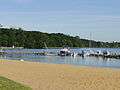 Beach in Zippendorf, a district of Schwerin
.jpg) The Beutel are of Lake Schwerin
The Beutel are of Lake Schwerin.jpg) Sunrise at the Marstall peninsula
Sunrise at the Marstall peninsula Schwerin seen from the Lake
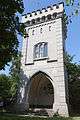 Observation tower on Kaninchenwerder, an island of Lake Schwerin
.jpg) Sunrise at Ziegelwerder island
Sunrise at Ziegelwerder island
References
- ↑ Kohl, Horst; Marcinek, Joachim and Nitz, Bernhard (1986). Geography of the German Democratic Republic, VEB Hermann Haack, Gotha, p. 49. ISBN 978-3-7301-0522-1.
- ↑ Frommer's Germany 2006 by Darwin Porter and Danforth Prince. Retrieved 1 Nov 2013.
External links
 Media related to Schweriner See at Wikimedia Commons
- Nixdorf, B.; et al. (2004), "Schweriner See" (PDF), Dokumentation von Zustand und Entwicklung der wichtigsten Seen Deutschlands (in German), Berlin: Umweltbundesamt, p. 265
This article is issued from Wikipedia - version of the 11/6/2016. The text is available under the Creative Commons Attribution/Share Alike but additional terms may apply for the media files.