Schwerin
| Schwerin | |||
|---|---|---|---|
|
Schwerin Palace - Parliament of Mecklenburg-Vorpommern | |||
| |||
 Schwerin | |||
| Coordinates: 53°38′0″N 11°25′0″E / 53.63333°N 11.41667°ECoordinates: 53°38′0″N 11°25′0″E / 53.63333°N 11.41667°E | |||
| Country | Germany | ||
| State | Mecklenburg-Vorpommern | ||
| District | Urban district | ||
| Government | |||
| • Lord Mayor | Rico Badenschier (SPD) | ||
| Area | |||
| • Total | 130.46 km2 (50.37 sq mi) | ||
| Population (2015-12-31)[1] | |||
| • Total | 96,800 | ||
| • Density | 740/km2 (1,900/sq mi) | ||
| Time zone | CET/CEST (UTC+1/+2) | ||
| Postal codes | 19053, 19055, 19057, 19059, 19061, 19063 | ||
| Dialling codes | 0385 | ||
| Vehicle registration | SN | ||
| Website | schwerin.de | ||


| County of Schwerin | ||||||||||
| Grafschaft Schwerin | ||||||||||
| State of the Holy Roman Empire | ||||||||||
| ||||||||||
|
| ||||||||||
.svg.png) County of Schwerin during the time of the Hohenstaufen Emperors (circa 1250) | ||||||||||
| Capital | Schwerin | |||||||||
| Government | Principality | |||||||||
| Historical era | Middle Ages | |||||||||
| • | Established | 1161 | ||||||||
| • | Partitioned to Schwerin and Sch-Wittenburg |
1279 | ||||||||
| • | Partitioned to create Sch-Boizenburg |
1323 | ||||||||
| • | Inherited Tecklenburg | 1328 | ||||||||
| • | Sch-Schwerin comital line extinct |
1344 | ||||||||
| • | Sch-W'burg-B'burg extinct | 1349 1358 | ||||||||
| • | Comital line extinct; sold to Mecklenburg-Schwerin |
1358 | ||||||||
| ||||||||||
| Bishopric of Schwerin | ||||||||||
| Bistum Schwerin | ||||||||||
| State of the Holy Roman Empire | ||||||||||
| ||||||||||
.svg.png) Bishopric of Schwerin during the time of the Hohenstaufen Emperors (circa 1250) | ||||||||||
| Capital | Schwerin | |||||||||
| Government | Theocracy | |||||||||
| Historical era | Middle Ages | |||||||||
| • | Established | 1062 | ||||||||
| • | Gained territory | 1165 | ||||||||
| • | Secularised to M-Schwerin | 1648 | ||||||||
| ||||||||||
Schwerin ([ʃvɛˈʁiːn] or [ʃvəˈʁiːn], Mecklenburgian Swerin, Latin Suerina) is the capital and second-largest city of the northern German state of Mecklenburg-Vorpommern. The population is 91,583 (as of December 31, 2013) and 98.000 as of July 2016.[2]
Schwerin was first mentioned in 1018 and was granted city rights in 1160, thus it is the oldest city of Mecklenburg-Vorpommern. It is known for its romantic Schwerin Palace, crowning an island in the Lake Schwerin. The city also has a largely intact old town, thanks to only minor damage in World War II.
Schwerin is located within the metropolitan region of Hamburg and close to that of Berlin, and to nearby regiopolises of Rostock and Lübeck.
History
Schwerin is surrounded by lakes. The largest of these lakes, the Schweriner See, has an area of 60 km2. In the midst of these lakes there was a settlement of the Slavic Obotrite (dated back to the 11th century). The area was called Zuarin (Polabian Zwierzyn), and the name Schwerin is derived from that designation. In 1160, Henry the Lion defeated the Obotrites and captured Schwerin. The town was subsequently expanded into a powerful regional centre. A castle was built on this site, and expanded to become a ducal palace. It is supposedly haunted by the small, impious ghost, called Petermännchen ("Peterman").
In 1358, Schwerin became a part of the Duchy of Mecklenburg, making it the seat of the duchy from then on. About 1500, the construction of the Schwerin Palace began, as a residence for the dukes. After the division of Mecklenburg (1621), Schwerin became the capital of the Duchy of Mecklenburg-Schwerin. Between 1765 and 1837, the town of Ludwigslust served as the capital, until Schwerin was reinstated.
In the mid-1800s, many residents from Schwerin moved to the United States, many to Milwaukee, Wisconsin. Today Milwaukee and Schwerin are sister cities.
After 1918, and during the German Revolution, resulting in the fall of all the German monarchies, the Grand Duke abdicated. Schwerin became capital of the Free State of Mecklenburg-Vorpommern thereafter.
At the end of World War II, on 2 May 1945, Schwerin was taken by U.S. troops. It was turned over to the British on 1 June 1945, and one month later, on 1 July 1945,[3] it was handed over to the Soviet forces, as the British and American forces pulled back from the line of contact to the predesignated occupation zones. Schwerin was then in the Soviet Occupation Zone which was to become the German Democratic Republic (GDR). Initially, it was the capital of the State of Mecklenburg which at that time included the western part of Pomerania (Vorpommern). After the states were dissolved in the GDR, in 1952, Schwerin served as the capital of the Schwerin district (Bezirk Schwerin).
After reunification in 1990, the former state of Mecklenburg-Vorpommern was recreated as one of the Bundesländer. Rostock was a serious contender for state capital but the decision went in favour of Schwerin.
Sister Cities
Transport
City buses and trams are run by NVS (Nahverkehr Schwerin).[4]
Schwerin Hauptbahnhof (central station) is connected by rail to Berlin, Hamburg and Rostock.
Main sights
- The landmark of the city is the Schwerin Palace, located on an island in the lake of the same name (Schweriner See). It was, for centuries, the residence of the Dukes of Mecklenburg and today is the seat of the Landtag (state parliament).
- Schwerin Cathedral, built in 1260–1416 in Brick Gothic style.
- The Alter Garten (Old Garden) square, surrounded by buildings such as the 18th-century Altes Palais (Old Palace), the neoclassical Staatliches Museum Schwerin (State Art Museum), built in 1877–1882, and the Staatstheater (City Theater), erected in 1886.
- The town hall (18th century)
- Schelfkirche (Saint Nicolai, originally built 1238, but rebuilt in 1713 after destruction by a storm)
- Television mast Schwerin-Zippendorf
Museums
- The Staatliches Museum Schwerin-Kunstsammlungen (State Art Museum) houses a remarkable collection of 17th-century Dutch paintings and German art from medieval and renaissance masters up to the present day. There are also a collection of Greek vases, the notable collection of Paintings of Jean-Baptiste Oudry, a collection of sculptures of Houdon, German 18th-century court paintings, and works by such modern artists as Max Liebermann, Franz Stuck, Marcel Duchamp etc. The Graphic cabinet houses rich collections of Dutch and German drawings and prints (Jan van Goyen, Dürer, Cranach, Rembrandt, Merian etc.) and a notable collection of coloured graphics from the time of the GDR.
- The State Museum of Technology (Technische Museum), housed in the former Marstall (Royal Stables). In 2012 the Technische Museum moved to the city of Wismar located 40 km north of Schwerin.
Sons and daughters of the town
18th century
- Konrad Ernst Ackermann (1712-1771), actor
- Friedrich Ludwig Schröder (1744-1816), actor, theater director and playwright
- Karl Albert von Kamptz (1769-1849), lawyer and Prussian State and Minister of Justice
19th century
- Karl Lemcke (1832-1913), art historian, songwriter, rector at the University of Stuttgart
- August Kundt (1839-1894), physicist
- Hans von Koester (1844-1928), naval officer
- Franziska Ellmenreich (1847-1931), actress
- Friedrich Klockmann (1858-1937), mineralogist
- Heinrich Friese (1860-1948), an entomologist and bee researcher
- Heinrich Cunow (1862-1938), ethnologist, writer and politician (SPD)
- Adolf Frederick, Duke of Mecklenburg-Schwerin (1873-1969), Africa traveler, colonial politician and first president of the German Olympic Committee
- Alexandrine, (1879-1952), Duchess of Mecklenburg-Schwerin
- Paul Gosch (1885-1940), painter and architect, Nazi victim
- Cecilie, Duchess of Mecklenburg-Schwerin(1886-1954), last Crown Princess of the German Empire
- Bernhard Schwentner (1891-1944), Catholic priest and resistance fighter
- Wilhelm Gustloff (1895-1936), Nazi party leader
1901-1950
- Ludwig Bölkow (1912-2003), industrialist
- Gudrun Zapf-von Hesse (born 1918), typographer and bookbinder
- Gabriele Hinzmann (born 1947), athlete
- André Brie (born 1950), politician (The Left)
1951 - 2000
- Anke Westendorf (born 1954), volleyball player
- Detlef Kübeck (born 1956), sprinter
- Rosemarie Kother (born 1956), swimmer

- Katrin Sass (born 1956), theater, film and television actress
- Heidrun Bluhm (born 1958), politician (The Left)
- Andrea Pollack (born 1961), swimmer
- Matthias Stammann (born 1968), football player
- Heike Balck (born 1970), athlete
- Sylvia Roll (born 1973), volleyball player
- Hanka Pachale (born 1976), volleyball player
- Cathrin Schlüter (born 1980), volleyball player
- Robert Müller (born 1986), football player
- Stephan Gusche (born 1990), football player
Gallery
 Aerial view of Schwerin Palace
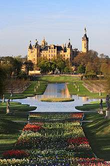 Schwerin Palace during the BUGA 2009, Germany's federal garden show
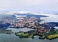 Aerial view of Schwerin
 View of Schwerin towards the center and its Brick Gothic Cathedral (Schweriner Dom)
 View of Schwerin's Schelfstadt quarter and its baroque Schelf Church, the large Lake Schwerin in the back
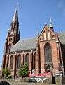 St. Paul's church
.jpg) Former power station (E-Werk)
Former power station (E-Werk)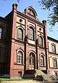 FHM, private university
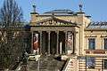 State Museum
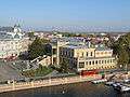 Schwerin's State Museum and Mecklenburg State Theatre
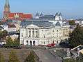
 In the Schlossgarten (royal garden of Schwerin)

Footnotes
- ↑ "Bevölkerungsstand der Kreise, Ämter und Gemeinden in Mecklenburg-Vorpommern 31.12.2015". Statistisches Amt Mecklenburg-Vorpommern (in German). July 2016.
- ↑ http://www.svz.de/lokales/zeitung-fuer-die-landeshauptstadt/eine-wachsende-grossstadt-id14346686.html
- ↑ Some evidence calls into doubt the date on which the British withdrew to the predesignated occupation zone. Local residents claim that the British forces did not relinquish control of Schwerin until later in the year, probably November, following a brief artillery exchange across lake Schwerin between the British and the Soviets. Allegedly there were no deaths.
- ↑ NVS (Nahverkehr Schwerin)
External links
| Wikivoyage has a travel guide for Schwerin. |
| Wikimedia Commons has media related to Schwerin. |
- Schwerin's official website (English)
- Tourism portal of Schwerin (English)
| Urban districts | ||
|---|---|---|
| Rural districts | ||
| Capitals of area states |
|
|---|---|
| City-states1 | |
| Capitals of former states |
|
| |
Capitals of the former East German Bezirke | ||
|---|---|---|
| Ecclesiastical |  | |
|---|---|---|
| Secular | ||
| Cities | ||
1 until 1648. 2 until 1701. 3 from 1648. 4 until 1731. 5 until 1705. 6 until 1596. 7 from 1708. 8 until 1773. 9 until 1640. 10 until 1695. 11 from 1701. 12 until 1734.
Circles est. 1500: Bavarian, Swabian, Upper Rhenish, Lower Rhenish–Westphalian, Franconian, (Lower) Saxon Circles est. 1512: Austrian, Burgundian, Upper Saxon, Electoral Rhenish · Unencircled territories | ||